
Magnitude |
:4.4 |
| Date & Time (UTC) | 2009-12-12 21:37:36.7 |
| Date & Time (Local) | 1388/9/22 01:07:36.7 |
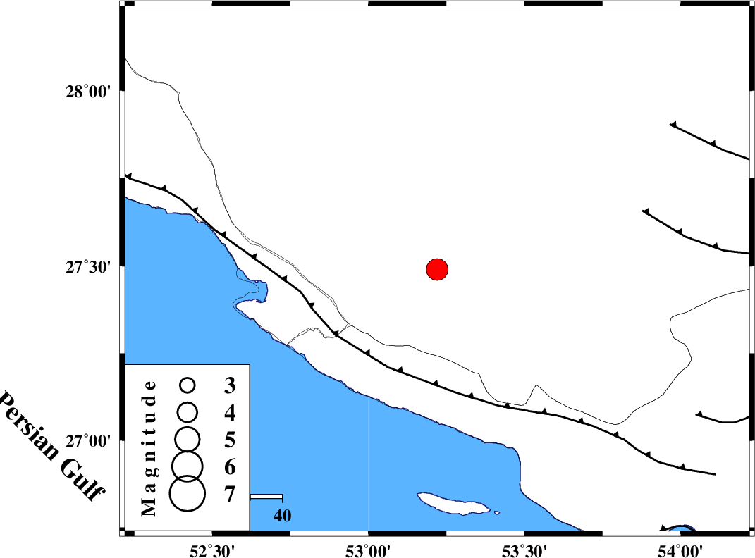
| Location | Lat:27.49 Lon: 53.22 |
| Region | Fars Province, 18 km North of Lamerd |
Nearest Cities |
|
| 18 km North of Lamerd, Fars Province | |
| 25 km North East of Khoozi, Fars Province | |
| 29 km South East of Alamarvdasht, Fars Province | |
| 30 km North West of Beyram, Fars Province | |
| 32 km West of Fedagh, Fars Province | |
| Depth | 27 km |
| Agency | |
Faults within 150 km: |
|
| MFF3 (Length: 292 km) , Distance to epicenter: 35 km | |
| LAR_F (Length: 99 km) , Distance to epicenter: 67 km | |
| QIR_F (Length: 130 km) , Distance to epicenter: 85 km | |
| Number of Phases | 5 |
| RMS | 0.1 |
| Number of Stations | 4 |
| Error in Latitude | >7.6 km |
| Error in Longitude | 10.1 km |
| Error in Depth | 8.1 km |
Download waveform in seisan format
to download seisan software Click here
to access information about IIEES stations Click here
Amplitude | ||||||||
| UID | Agency | Station | Component | Amplitude | Period | Arrival Time | Proccessing Time | Signal Clip |
| 59482 | IIEES | GHIR | N | 12423.3 | 0.45 | 2009-12-12 21:38:09 | 2010-02-08 11:55:00 | n |
| 59483 | IIEES | KRBR | E | 783.7 | 0.27 | 2009-12-12 21:39:25 | 2010-02-08 11:55:00 | n |
| 59484 | IIEES | KRBR | N | 1176 | 0.67 | 2009-12-12 21:39:25 | 2010-02-08 11:55:00 | n |
| 59485 | IIEES | NASN | N | 65.8 | 0.32 | 2009-12-12 21:39:04 | 2010-02-08 11:55:00 | n |
Phase | ||||||||||||
| Agency | Station | Component | Phase Type | Phase Quality | First Motion | Observed Arrival Time | Time Residual | Loc. Flag | Input Weight | Distance | Azimuth | |
| IIEES | GHIR | Z | Pg | E | 2009-12-12 21:37:52 | 0 | y | 91.1 | 345 | |||
| IIEES | GHIR | E | Sg | E | 2009-12-12 21:38:03 | 0 | y | 91.1 | 345 | |||
| IIEES | KRBR | Z | Pn | E | 2009-12-12 21:38:38 | 0.1 | y | 443 | 51 | |||
| IIEES | NASN | Z | Pn | E | 2009-12-12 21:38:56 | 0.1 | y | 590 | 356 | |||
| IIEES | TABS | Z | Pn | E | 2009-12-12 21:39:19 | -0.3 | y | 778 | 28 | |||