
Magnitude |
:2.7 |
| Date & Time (UTC) | 2009-12-05 04:23:44.9 |
| Date & Time (Local) | 1388/9/14 07:53:44.9 |
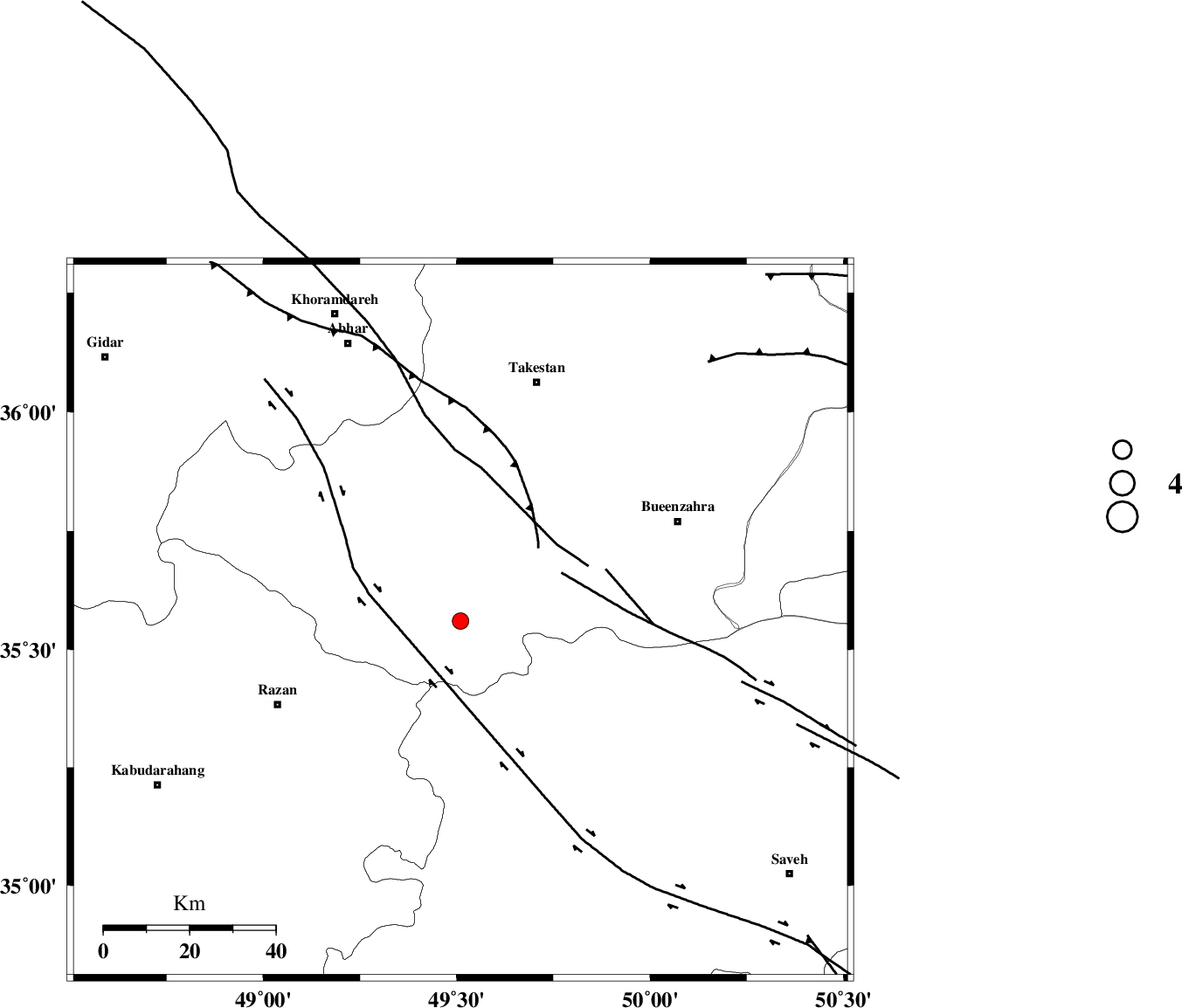
| Location | Lat:35.56 Lon: 49.51 |
| Region | Ghazvin Province, 47 km North-East of Razan |
Nearest Cities |
|
| 8 km of Kolanjin, Ghazvin Province | |
| 25 km East of Avaj, Ghazvin Province | |
| 30 km South East of Ab-e garm, Ghazvin Province | |
| 32 km South West of Danesfahan, Ghazvin Province | |
| 32 km South East of Hoseynabad, Ghazvin Province | |
| Depth | 14 km |
| Agency | |
Faults within 150 km: |
|
| KUSHK_E_NOSRAT_F (Length: 230 km) , Distance to epicenter: 6 km | |
| S_PARANDAK_F (Length: 116 km) , Distance to epicenter: 17 km | |
| IPAK_F (Length: 80 km) , Distance to epicenter: 29 km | |
| Number of Phases | 6 |
| RMS | 0.3 |
| Number of Stations | 6 |
| Error in Latitude | >3.9 km |
| Error in Longitude | 6.7 km |
| Error in Depth | 11.3 km |
Download waveform in seisan format
to download seisan software Click here
to access information about IIEES stations Click here
Amplitude | ||||||||
| UID | Agency | Station | Component | Amplitude | Period | Arrival Time | Proccessing Time | Signal Clip |
| 59416 | IIEES | CHTH | E | 142.4 | 0.25 | 2009-12-05 04:24:28 | 2010-02-08 11:55:00 | n |
| 59417 | IIEES | GHVR | E | 55.7 | 0.45 | 2009-12-05 04:24:50 | 2010-02-08 11:55:00 | n |
Phase | ||||||||||||
| Agency | Station | Component | Phase Type | Phase Quality | First Motion | Observed Arrival Time | Time Residual | Loc. Flag | Input Weight | Distance | Azimuth | |
| IIEES | ASAO | Z | Pg | E | 2009-12-05 04:24:05 | 0.3 | y | 122 | 157 | |||
| IIEES | ZNJK | Z | Pg | E | 2009-12-05 04:24:08 | -0.1 | y | 144 | 329 | |||
| IIEES | CHTH | Z | Pg | E | 2009-12-05 04:24:10 | 0.1 | y | 152 | 75 | |||
| IIEES | GHVR | Z | Pg | E | 2009-12-05 04:24:16 | -0.6 | y | 199 | 126 | |||
| IIEES | KHMZ | Z | Pg | E | 2009-12-05 04:24:18 | 0 | y | 206 | 168 | |||
| IIEES | DAMV | Z | Pn | E | 2009-12-05 04:24:20 | 0.3 | y | 223 | 87 | |||