
Magnitude |
:2.7 |
| Date & Time (UTC) | 2009-11-18 00:47:11.3 |
| Date & Time (Local) | 1388/8/27 04:17:11.3 |
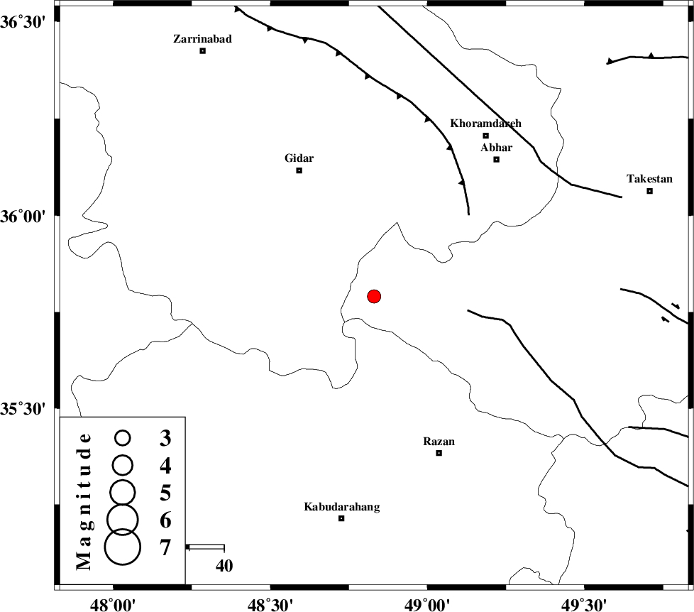
| Location | Lat:35.79 Lon: 48.83 |
| Region | Ghazvin Province, 42 km South-East of Qeydar |
Nearest Cities |
|
| 19 km North East of Kahla, Zanjan Province | |
| 30 km North of Khorandeh, Hamedan Province | |
| 32 km North East of Zarrinabad, Zanjan Province | |
| 38 km South of Kineh vars, Zanjan Province | |
| 38 km North East of Babanazar, Hamedan Province | |
| Depth | 14 km |
| Agency | |
Faults within 150 km: |
|
| KUSHK_E_NOSRAT_F (Length: 230 km) , Distance to epicenter: 27 km | |
| SOLTANIYEH_F (Length: 119 km) , Distance to epicenter: 36 km | |
| ZANJAN_F (Length: 137 km) , Distance to epicenter: 62 km | |
| Number of Phases | 5 |
| RMS | 0.2 |
| Number of Stations | 4 |
| Error in Latitude | >4.4 km |
| Error in Longitude | 15.3 km |
| Error in Depth | 9.2 km |
Download waveform in seisan format
to download seisan software Click here
to access information about IIEES stations Click here
Amplitude | ||||||||
| UID | Agency | Station | Component | Amplitude | Period | Arrival Time | Proccessing Time | Signal Clip |
| 59207 | IIEES | ASAO | E | 86.4 | 0.68 | 2009-11-18 00:48:02 | 2010-02-08 11:55:00 | n |
| 59208 | IIEES | KHMZ | N | 65.4 | 0.4 | 2009-11-18 00:48:25 | 2010-02-08 11:55:00 | n |
| 59209 | IIEES | KHMZ | E | 54.5 | 0.56 | 2009-11-18 00:48:26 | 2010-02-08 11:55:00 | n |
| 59210 | IIEES | DAMV | N | 32.1 | 0.44 | 2009-11-18 00:48:33 | 2010-02-08 11:55:00 | n |
| 59211 | IIEES | DAMV | E | 27.8 | 0.56 | 2009-11-18 00:48:37 | 2010-02-08 11:55:00 | n |
Phase | ||||||||||||
| Agency | Station | Component | Phase Type | Phase Quality | First Motion | Observed Arrival Time | Time Residual | Loc. Flag | Input Weight | Distance | Azimuth | |
| IIEES | ASAO | Z | Pg | E | 2009-11-18 00:47:40 | 0.2 | y | 176 | 141 | |||
| IIEES | CHTH | Z | Pg | E | 2009-11-18 00:47:45 | -0.2 | y | 208 | 86 | |||
| IIEES | KHMZ | Z | Pg | E | 2009-11-18 00:47:52 | -0.2 | y | 250 | 155 | |||
| IIEES | KHMZ | E | Sg | E | 2009-11-18 00:48:22 | 0 | y | 250 | 155 | |||
| IIEES | DAMV | Z | Pn | E | 2009-11-18 00:47:54 | 0.2 | y | 285 | 93 | |||