
Magnitude |
:2.5 |
| Date & Time (UTC) | 2009-11-15 23:50:41.0 |
| Date & Time (Local) | 1388/8/25 03:20:41.0 |
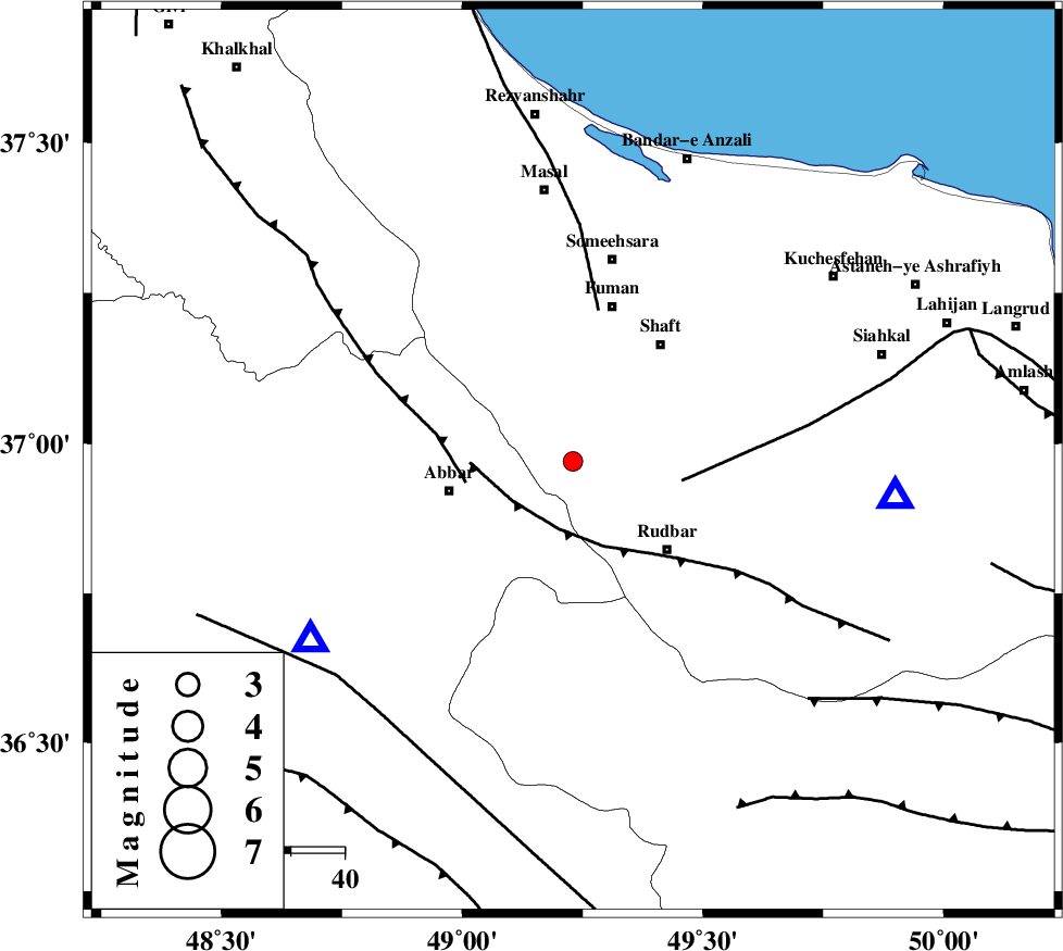
| Location | Lat:36.97 Lon: 49.23 |
| Region | Gilan Province, 24 km East of Abbar |
Nearest Cities |
|
| 9 km of Siyahmargi, Gilan Province | |
| 14 km South of Qaleh rudkhan, Gilan Province | |
| 17 km South of Rudkhan, Gilan Province | |
| 18 km South of Gorabpas, Gilan Province | |
| 21 km South of Balamakolovan, Gilan Province | |
| Depth | 14 km |
| Agency | |
Faults within 150 km: |
|
| RUDBAR_F (Length: 93 km) , Distance to epicenter: 13 km | |
| MASULEL_F (Length: 90 km) , Distance to epicenter: 20 km | |
| LAHIJAN_F (Length: 92 km) , Distance to epicenter: 20 km | |
| Number of Phases | 6 |
| RMS | 0.2 |
| Number of Stations | 5 |
| Error in Latitude | >3.5 km |
| Error in Longitude | 3.4 km |
| Error in Depth | 7.4 km |
Download waveform in seisan format
to download seisan software Click here
to access information about IIEES stations Click here
Amplitude | ||||||||
| UID | Agency | Station | Component | Amplitude | Period | Arrival Time | Proccessing Time | Signal Clip |
| 59190 | IIEES | ZNJK | E | 246 | 0.32 | 2009-11-15 23:50:59 | 2010-02-08 11:55:00 | n |
| 59191 | IIEES | DAMV | N | 21.7 | 0.44 | 2009-11-15 23:52:02 | 2010-02-08 11:55:00 | n |
| 59192 | IIEES | DAMV | E | 23.7 | 0.6 | 2009-11-15 23:52:03 | 2010-02-08 11:55:00 | n |
Phase | ||||||||||||
| Agency | Station | Component | Phase Type | Phase Quality | First Motion | Observed Arrival Time | Time Residual | Loc. Flag | Input Weight | Distance | Azimuth | |
| IIEES | ZNJK | Z | Pg | E | 2009-11-15 23:50:51 | 0.2 | y | 59.2 | 236 | |||
| IIEES | ZNJK | E | Sg | E | 2009-11-15 23:50:59 | -0.1 | y | 59.2 | 236 | |||
| IIEES | CHTH | Z | Pg | E | 2009-11-15 23:51:14 | -0.4 | y | 207 | 124 | |||
| IIEES | GRMI | Z | Pg | E | 2009-11-15 23:51:19 | -0.1 | y | 235 | 330 | |||
| IIEES | SNGE | Z | Pn | E | 2009-11-15 23:51:22 | 0 | y | 269 | 220 | |||
| IIEES | DAMV | Z | Pn | E | 2009-11-15 23:51:25 | 0.4 | y | 288 | 120 | |||