
Magnitude |
:3.2 |
| Date & Time (UTC) | 2009-10-30 12:17:08.5 |
| Date & Time (Local) | 1388/8/8 15:47:08.5 |
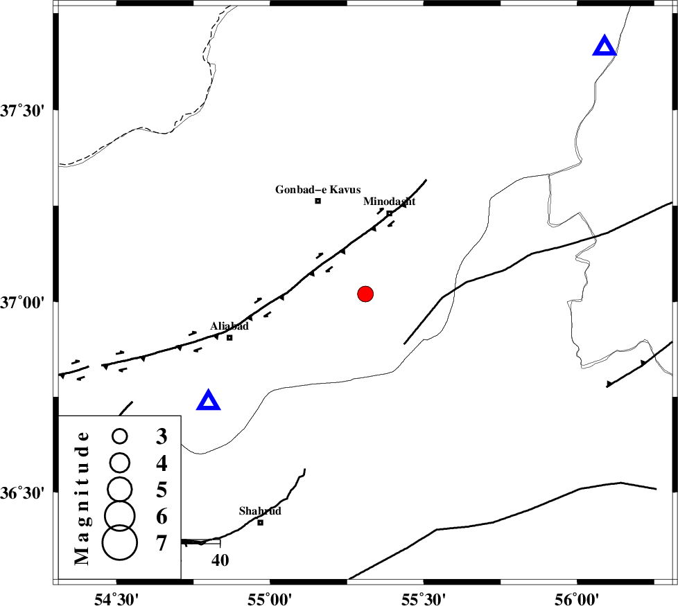
| Location | Lat:37.02 Lon: 55.31 |
| Region | Golestan Province, 14 km East of Ramian |
Nearest Cities |
|
| 10 km East of Khanduz, Golestan Province | |
| 13 km North West of Farsian, Golestan Province | |
| 14 km East of Azadshahr, Golestan Province | |
| 15 km North East of Ramian, Golestan Province | |
| 17 km West of Qale-ye qafeh, Golestan Province | |
| Depth | 14 km |
| Agency | |
Faults within 150 km: |
|
| ROBATE_QARABIL_F (Length: 168 km) , Distance to epicenter: 18 km | |
| SHAVAR_F (Length: 87 km) , Distance to epicenter: 29 km | |
| KHAZAR_F (Length: 523 km) , Distance to epicenter: 31 km | |
| Number of Phases | 5 |
| RMS | 0.4 |
| Number of Stations | 5 |
| Error in Latitude | >5.9 km |
| Error in Longitude | 8.3 km |
| Error in Depth | 0 km |
Download waveform in seisan format
to download seisan software Click here
to access information about IIEES stations Click here
Amplitude | ||||||||
| UID | Agency | Station | Component | Amplitude | Period | Arrival Time | Proccessing Time | Signal Clip |
| 59119 | IIEES | MRVT | N | 550 | 0.17 | 2009-10-30 12:17:44 | 2010-02-08 11:55:00 | n |
| 59120 | IIEES | DAMV | E | 114.9 | 0.56 | 2009-10-30 12:18:43 | 2010-02-08 11:55:00 | n |
| 59121 | IIEES | DAMV | N | 82.3 | 0.6 | 2009-10-30 12:18:47 | 2010-02-08 11:55:00 | n |
Phase | ||||||||||||
| Agency | Station | Component | Phase Type | Phase Quality | First Motion | Observed Arrival Time | Time Residual | Loc. Flag | Input Weight | Distance | Azimuth | |
| IIEES | MRVT | Z | Pg | E | 2009-10-30 12:17:24 | -0.6 | y | 99.1 | 44 | |||
| IIEES | SHRO | Z | Pg | E | 2009-10-30 12:17:30 | -0.1 | y | 129 | 150 | |||
| IIEES | BJRD | Z | Pg | E | 2009-10-30 12:17:42 | 0.7 | y | 201 | 67 | |||
| IIEES | DAMV | Z | Pn | E | 2009-10-30 12:17:58 | 0.2 | y | 337 | 244 | |||
| IIEES | TABS | Z | Pn | E | 2009-10-30 12:18:06 | -0.2 | y | 409 | 156 | |||