
Magnitude |
:3.3 |
| Date & Time (UTC) | 2009-10-29 11:32:10.9 |
| Date & Time (Local) | 1388/8/7 15:02:10.9 |
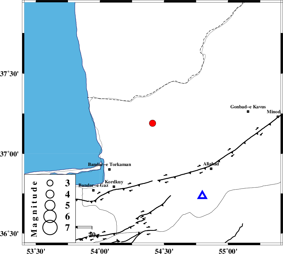
| Location | Lat:37.19 Lon: 54.41 |
| Region | Golestan Province, 20 km North of Aq Qaleh |
Nearest Cities |
|
| 20 km North of Aq Qaleh, Golestan Province | |
| 21 km North of Qanqarmeh, Golestan Province | |
| 26 km North East of Banavar, Golestan Province | |
| 29 km North West of Nodeh malek, Golestan Province | |
| 31 km North East of Gomishtappeh, Golestan Province | |
| Depth | 18 km |
| Agency | |
Faults within 150 km: |
|
| KHAZAR_F (Length: 523 km) , Distance to epicenter: 38 km | |
| N_ALBORZ_F (Length: 360 km) , Distance to epicenter: 64 km | |
| SHAVAR_F (Length: 87 km) , Distance to epicenter: 69 km | |
| Number of Phases | 4 |
| RMS | 0 |
| Number of Stations | 4 |
| Error in Latitude | >3.1 km |
| Error in Longitude | 4.1 km |
| Error in Depth | 6.5 km |
Download waveform in seisan format
to download seisan software Click here
to access information about IIEES stations Click here
Amplitude | ||||||||
| UID | Agency | Station | Component | Amplitude | Period | Arrival Time | Proccessing Time | Signal Clip |
| 59113 | IIEES | MRVT | N | 482.4 | 0.38 | 2009-10-29 11:33:00 | 2010-02-08 11:55:00 | n |
| 59114 | IIEES | DAMV | N | 123 | 0.45 | 2009-10-29 11:33:33 | 2010-02-08 11:55:00 | n |
| 59115 | IIEES | DAMV | E | 119.1 | 0.26 | 2009-10-29 11:33:35 | 2010-02-08 11:55:00 | n |
Phase | ||||||||||||
| Agency | Station | Component | Phase Type | Phase Quality | First Motion | Observed Arrival Time | Time Residual | Loc. Flag | Input Weight | Distance | Azimuth | |
| IIEES | MRVT | Z | Pg | E | 2009-10-29 11:32:37 | 0 | y | 157 | 70 | |||
| IIEES | SHRO | Z | Pg | E | 2009-10-29 11:32:43 | 0 | y | 194 | 132 | |||
| IIEES | DAMV | Z | Pn | E | 2009-10-29 11:32:53 | 0 | y | 279 | 232 | |||
| IIEES | TABS | Z | Pn | E | 2009-10-29 11:33:15 | -0.1 | y | 464 | 147 | |||