
Magnitude |
:2.6 |
| Date & Time (UTC) | 2009-10-19 22:04:45.0 |
| Date & Time (Local) | 1388/7/28 01:34:45.0 |
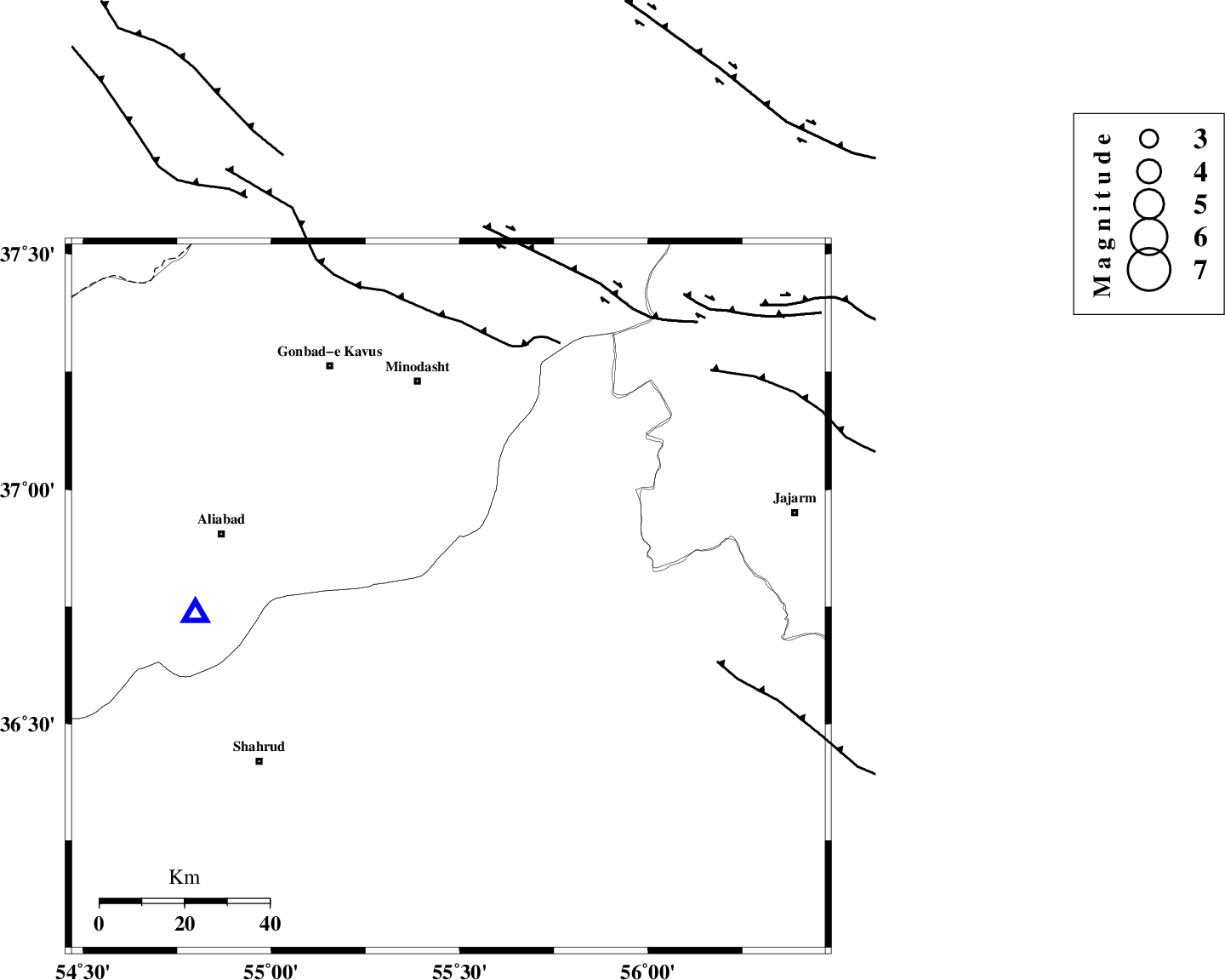
| Location | Lat:36.77 Lon: 55.47 |
| Region | Semnan Province, 52 km South of Minodasht |
Nearest Cities |
|
| 18 km North East of Kalateh khanj, Semnan Province | |
| 20 km South of Farsian, Golestan Province | |
| 29 km South West of Qaleh qafeh, Semnan Province | |
| 30 km South of Qale-ye qafeh, Golestan Province | |
| 36 km North East of Qaleh-ye nokharqan, Semnan Province | |
| Depth | 14 km |
| Agency | |
Faults within 150 km: |
|
| ROBATE_QARABIL_F (Length: 168 km) , Distance to epicenter: 13 km | |
| SHAVAR_F (Length: 87 km) , Distance to epicenter: 23 km | |
| MEYAMEY_F (Length: 141 km) , Distance to epicenter: 42 km | |
| Number of Phases | 6 |
| RMS | 0.3 |
| Number of Stations | 4 |
| Error in Latitude | >4.8 km |
| Error in Longitude | 6.1 km |
| Error in Depth | 9.1 km |
Download waveform in seisan format
to download seisan software Click here
to access information about IIEES stations Click here
Amplitude | ||||||||
| UID | Agency | Station | Component | Amplitude | Period | Arrival Time | Proccessing Time | Signal Clip |
| 59104 | IIEES | BJRD | E | 36.7 | 0.39 | 2009-10-19 22:05:52 | 2010-02-08 11:55:00 | n |
| 59105 | IIEES | DAMV | N | 17.7 | 0.6 | 2009-10-19 22:06:24 | 2010-02-08 11:55:00 | n |
| 59106 | IIEES | DAMV | E | 27.9 | 0.6 | 2009-10-19 22:06:24 | 2010-02-08 11:55:00 | n |
Phase | ||||||||||||
| Agency | Station | Component | Phase Type | Phase Quality | First Motion | Observed Arrival Time | Time Residual | Loc. Flag | Input Weight | Distance | Azimuth | |
| IIEES | SHRO | Z | Pg | E | 2009-10-19 22:05:01 | -0.4 | y | 96.9 | 150 | |||
| IIEES | BJRD | Z | Pg | E | 2009-10-19 22:05:17 | -0.3 | y | 201 | 58 | |||
| IIEES | BJRD | N | Sg | E | 2009-10-19 22:05:42 | 0.2 | y | 201 | 58 | |||
| IIEES | DAMV | Z | Pn | E | 2009-10-19 22:05:35 | 0 | y | 339 | 249 | |||
| IIEES | TABS | Z | Pn | E | 2009-10-19 22:05:40 | 0.5 | y | 377 | 156 | |||
| IIEES | TABS | E | Sn | 2009-10-19 22:06:19 | 0.1 | y | 377 | 156 | ||||