
Magnitude |
:3 |
| Date & Time (UTC) | 2009-10-14 16:11:48.6 |
| Date & Time (Local) | 1388/7/22 19:41:48.6 |
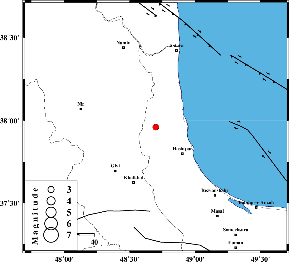
| Location | Lat:37.96 Lon: 48.7 |
| Region | Gilan Province, 25 km North-West of Hashtpar |
Nearest Cities |
|
| 18 km North West of Kish dini, Gilan Province | |
| 20 km West of Lisar, Gilan Province | |
| 22 km North West of Chelonasr, Gilan Province | |
| 24 km South East of Hir, Ardebil Province | |
| 25 km North West of Hashtpar, Gilan Province | |
| Depth | 15 km |
| Agency | |
Faults within 150 km: |
|
| SANGAVAR_F (Length: 61 km) , Distance to epicenter: 20 km | |
| TALESH_F (Length: 258 km) , Distance to epicenter: 21 km | |
| MASULEL_F (Length: 90 km) , Distance to epicenter: 48 km | |
| Number of Phases | 5 |
| RMS | 0.2 |
| Number of Stations | 4 |
| Error in Latitude | >5.7 km |
| Error in Longitude | 16.3 km |
| Error in Depth | 7.6 km |
Download waveform in seisan format
to download seisan software Click here
to access information about IIEES stations Click here
Amplitude | ||||||||
| UID | Agency | Station | Component | Amplitude | Period | Arrival Time | Proccessing Time | Signal Clip |
| 58981 | IIEES | GRMI | E | 336.9 | 0.2 | 2009-10-14 16:12:25 | 2010-02-08 11:55:00 | n |
| 58982 | IIEES | GRMI | N | 429.1 | 0.16 | 2009-10-14 16:12:26 | 2010-02-08 11:55:00 | n |
| 58983 | IIEES | ZNJK | E | 283.5 | 0.24 | 2009-10-14 16:12:31 | 2010-02-08 11:55:00 | n |
Phase | ||||||||||||
| Agency | Station | Component | Phase Type | Phase Quality | First Motion | Observed Arrival Time | Time Residual | Loc. Flag | Input Weight | Distance | Azimuth | |
| IIEES | GRMI | Z | Pg | E | 2009-10-14 16:12:08 | -0.1 | y | 118 | 324 | |||
| IIEES | GRMI | E | Sg | E | 2009-10-14 16:12:22 | 0 | y | 118 | 324 | |||
| IIEES | ZNJK | Z | Pg | E | 2009-10-14 16:12:12 | -0.4 | y | 143 | 180 | |||
| IIEES | SNGE | Z | Pn | E | 2009-10-14 16:12:38 | 0.3 | y | 340 | 201 | |||
| IIEES | ASAO | Z | Pn | E | 2009-10-14 16:12:45 | 0.2 | y | 397 | 162 | |||