
Magnitude |
:4.9 |
| Date & Time (UTC) | 2009-10-13 00:54:27.7 |
| Date & Time (Local) | 1388/7/21 04:24:27.7 |
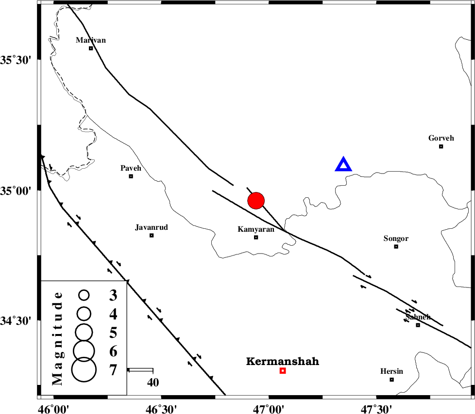
| Location | Lat:34.96 Lon: 46.94 |
| Region | Kordestan Province, 16 km North of Kamyaran |
Nearest Cities |
|
| 5 km of Yoosefabad, Kurdistan Province | |
| 6 km of Kuleh sareh, Kurdistan Province | |
| 6 km of Void, Kurdistan Province | |
| 6 km of Void, Kurdistan Province | |
| 16 km North of Kamyaran, Kurdistan Province | |
| Depth | 15 km |
| Agency | |
Faults within 150 km: |
|
| MORVARID_F (Length: 24 km) , Distance to epicenter: 7 km | |
| SARTAKHT_F (Length: 78 km) , Distance to epicenter: 10 km | |
| PIRANSHAHR_F (Length: 253 km) , Distance to epicenter: 12 km | |
| Number of Phases | 8 |
| RMS | 0.4 |
| Number of Stations | 8 |
| Error in Latitude | >6.9 km |
| Error in Longitude | 9.8 km |
| Error in Depth | 0 km |
Download waveform in seisan format
to download seisan software Click here
to access information about IIEES stations Click here
Amplitude | ||||||||
| UID | Agency | Station | Component | Amplitude | Period | Arrival Time | Proccessing Time | Signal Clip |
| 58961 | IIEES | KHMZ | E | 5294.7 | 0.64 | 2009-10-13 00:56:05 | 2010-02-08 11:55:00 | n |
| 58962 | IIEES | KHMZ | N | 3281.5 | 0.52 | 2009-10-13 00:56:07 | 2010-02-08 11:55:00 | n |
| 58963 | IIEES | SHGR | E | 2702.6 | 0.6 | 2009-10-13 00:56:21 | 2010-02-08 11:55:00 | n |
| 58964 | IIEES | SHGR | N | 3282.5 | 0.68 | 2009-10-13 00:56:22 | 2010-02-08 11:55:00 | n |
| 58965 | IIEES | GHVR | E | 2172.5 | 0.68 | 2009-10-13 00:56:44 | 2010-02-08 11:55:00 | n |
| 58966 | IIEES | GHVR | N | 1825.5 | 0.76 | 2009-10-13 00:56:49 | 2010-02-08 11:55:00 | n |
Phase | ||||||||||||
| Agency | Station | Component | Phase Type | Phase Quality | First Motion | Observed Arrival Time | Time Residual | Loc. Flag | Input Weight | Distance | Azimuth | |
| IIEES | ZNJK | Z | Pn | E | 2009-10-13 00:55:06 | 0.2 | y | 246 | 39 | |||
| IIEES | ASAO | Z | Pn | E | 2009-10-13 00:55:11 | 0.9 | y | 286 | 98 | |||
| IIEES | KHMZ | Z | Pn | E | 2009-10-13 00:55:13 | -0.4 | y | 309 | 115 | |||
| IIEES | SHGR | Z | Pn | E | 2009-10-13 00:55:20 | 0.2 | y | 361 | 151 | |||
| IIEES | GHVR | Z | Pn | E | 2009-10-13 00:55:24 | -0.2 | y | 398 | 97 | |||
| IIEES | GRMI | Z | Pn | E | 2009-10-13 00:55:29 | -0.2 | y | 435 | 11 | |||
| IIEES | DAMV | Z | Pn | E | 2009-10-13 00:55:32 | -0.3 | y | 463 | 79 | |||
| IIEES | NASN | Z | Pn | E | 2009-10-13 00:55:48 | -0.5 | y | 593 | 112 | |||