
Magnitude |
:2.9 |
| Date & Time (UTC) | 2009-10-10 12:18:06.2 |
| Date & Time (Local) | 1388/7/18 15:48:06.2 |
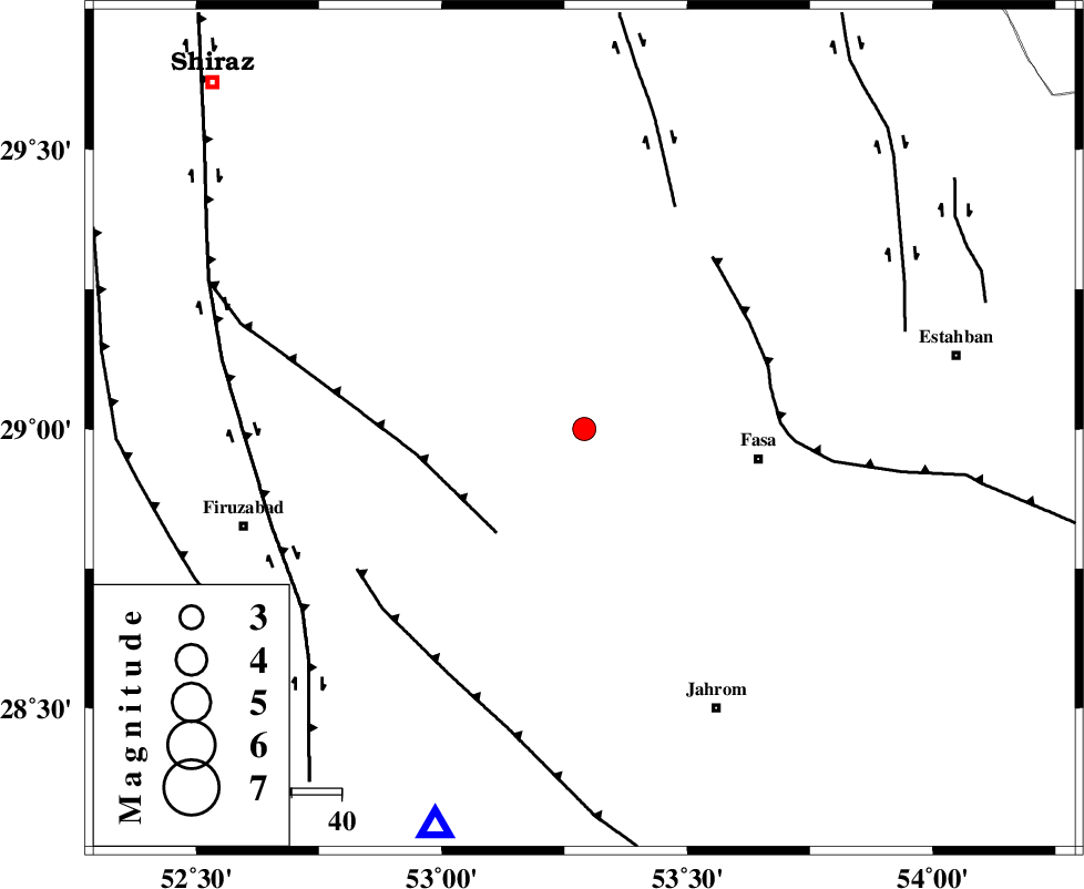
| Location | Lat:29 Lon: 53.29 |
| Region | Fars Province, 35 km West of Fasa |
Nearest Cities |
|
| 6 km of Khavaran, Fars Province | |
| 7 km North of Babanar, Fars Province | |
| 9 km North of Golberenji, Fars Province | |
| 20 km North of Tadvan, Fars Province | |
| 32 km South of Sarvestan, Fars Province | |
| Depth | 37 km |
| Agency | |
Faults within 150 km: |
|
| SARVESTAN_F (Length: 94 km) , Distance to epicenter: 14 km | |
| BAKHTEGAN_F (Length: 94 km) , Distance to epicenter: 31 km | |
| SABZ_PUSHAN_F_Z2 (Length: 24 km) , Distance to epicenter: 44 km | |
| Number of Phases | 4 |
| RMS | 0 |
| Number of Stations | 4 |
| Error in Latitude | >4.3 km |
| Error in Longitude | 6.6 km |
| Error in Depth | 9.9 km |
Download waveform in seisan format
to download seisan software Click here
to access information about IIEES stations Click here
Amplitude | ||||||||
| UID | Agency | Station | Component | Amplitude | Period | Arrival Time | Proccessing Time | Signal Clip |
| 58931 | IIEES | GHIR | E | 380.2 | 0.44 | 2009-10-10 12:18:35 | 2010-02-08 11:55:00 | n |
| 58932 | IIEES | KRBR | E | 25.9 | 0.88 | 2009-10-10 12:19:47 | 2010-02-08 11:55:00 | n |
| 58933 | IIEES | KRBR | N | 31 | 0.46 | 2009-10-10 12:19:47 | 2010-02-08 11:55:00 | n |
Phase | ||||||||||||
| Agency | Station | Component | Phase Type | Phase Quality | First Motion | Observed Arrival Time | Time Residual | Loc. Flag | Input Weight | Distance | Azimuth | |
| IIEES | GHIR | Z | Pg | E | 2009-10-10 12:18:21 | 0 | y | 85 | 201 | |||
| IIEES | BNDS | Z | Pn | E | 2009-10-10 12:18:53 | 0 | y | 334 | 121 | |||
| IIEES | KRBR | Z | PN5 | E | 2009-10-10 12:18:55 | 0 | y | 354 | 71 | |||
| IIEES | NASN | Z | Pn | E | 2009-10-10 12:19:04 | 0 | y | 423 | 354 | |||