
Magnitude |
:3.4 |
| Date & Time (UTC) | 2009-09-11 20:52:59.7 |
| Date & Time (Local) | 1388/6/21 01:22:59.7 |
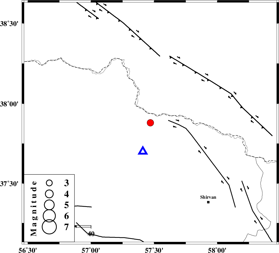
| Location | Lat:37.88 Lon: 57.47 |
| Region | Khorasan(north) Province, 47 km North-East of Bojnurd |
Nearest Cities |
|
| 2 km of Gifan olia, Khorasan(north) Province | |
| 29 km North West of Yangi ghale-ye bala, Khorasan(north) Province | |
| 31 km East of Raz, Khorasan(north) Province | |
| 39 km North West of Tukur, Khorasan(north) Province | |
| 40 km North of Hesar-egarmkhanh, Khorasan(north) Province | |
| Depth | 14 km |
| Agency | |
Faults within 150 km: |
|
| BAGHAN_GERMAB_F (Length: 79 km) , Distance to epicenter: 13 km | |
| MAIN_KOPEHDAGH_F2 (Length: 131 km) , Distance to epicenter: 47 km | |
| MAIN_KOPEHDAGH_F3 (Length: 96 km) , Distance to epicenter: 48 km | |
| Number of Phases | 5 |
| RMS | 0.1 |
| Number of Stations | 5 |
| Error in Latitude | >10.1 km |
| Error in Longitude | 7.8 km |
| Error in Depth | 3.8 km |
Download waveform in seisan format
to download seisan software Click here
to access information about IIEES stations Click here
Amplitude | ||||||||
| UID | Agency | Station | Component | Amplitude | Period | Arrival Time | Proccessing Time | Signal Clip |
| 58691 | IIEES | MRVT | N | 1730.4 | 0.56 | 2009-09-11 20:53:40 | 2009-10-25 09:10:00 | n |
| 58692 | IIEES | MRVT | E | 1408.5 | 0.34 | 2009-09-11 20:53:40 | 2009-10-25 09:10:00 | n |
| 58693 | IIEES | SHRO | N | 64.2 | 0.83 | 2009-09-11 20:54:08 | 2009-10-25 09:10:00 | n |
Phase | ||||||||||||
| Agency | Station | Component | Phase Type | Phase Quality | First Motion | Observed Arrival Time | Time Residual | Loc. Flag | Input Weight | Distance | Azimuth | |
| IIEES | BJRD | Z | Pg | E | 2009-09-11 20:53:04 | -0.1 | y | 20.9 | 196 | |||
| IIEES | MRVT | Z | Pg | E | 2009-09-11 20:53:20 | 0 | y | 124 | 259 | |||
| IIEES | SHRO | Z | Pn | E | 2009-09-11 20:53:37 | 0 | y | 245 | 213 | |||
| IIEES | TABS | Z | Pn | E | 2009-09-11 20:54:05 | 0.3 | y | 471 | 184 | |||
| IIEES | SHRT | Z | Pn | E | 2009-09-11 20:54:13 | -0.1 | y | 534 | 151 | |||