
Magnitude |
:2.9 |
| Date & Time (UTC) | 2009-09-17 13:40:04.4 |
| Date & Time (Local) | 1388/6/26 18:10:04.4 |
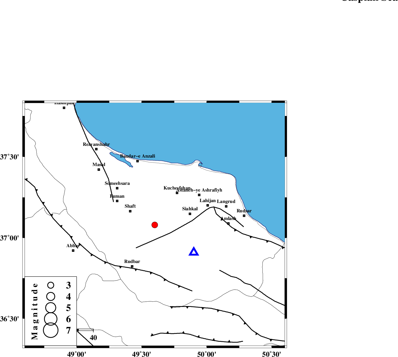
| Location | Lat:37.08 Lon: 49.6 |
| Region | Gilan Province, 22 km South of Rasht |
Nearest Cities |
|
| 3 km of Jirdeh, Gilan Province | |
| 3 km North of Eskolak, Gilan Province | |
| 6 km North of Saravan, Gilan Province | |
| 8 km North of Shahr-e bijar, Gilan Province | |
| 10 km West of Eslamabad, Gilan Province | |
| Depth | 14 km |
| Agency | |
Faults within 150 km: |
|
| LAHIJAN_F (Length: 92 km) , Distance to epicenter: 12 km | |
| TALESH_F (Length: 258 km) , Distance to epicenter: 32 km | |
| RUDBAR_F (Length: 93 km) , Distance to epicenter: 33 km | |
| Number of Phases | 6 |
| RMS | 0.3 |
| Number of Stations | 5 |
| Error in Latitude | >13.5 km |
| Error in Longitude | 18 km |
| Error in Depth | 12.5 km |
Download waveform in seisan format
to download seisan software Click here
to access information about IIEES stations Click here
Amplitude | ||||||||
| UID | Agency | Station | Component | Amplitude | Period | Arrival Time | Proccessing Time | Signal Clip |
| 58576 | IIEES | CHTH | E | 94.7 | 0.36 | 2009-09-17 13:41:00 | 2009-10-25 09:10:00 | n |
| 58577 | IIEES | GRMI | N | 69.7 | 0.4 | 2009-09-17 13:41:19 | 2009-10-25 09:10:00 | n |
| 58578 | IIEES | GRMI | E | 76.5 | 0.56 | 2009-09-17 13:41:19 | 2009-10-25 09:10:00 | n |
| 58579 | IIEES | ASAO | N | 38.2 | 0.36 | 2009-09-17 13:41:28 | 2009-10-25 09:10:00 | n |
| 58580 | IIEES | GHVR | N | 43.7 | 0.56 | 2009-09-17 13:41:41 | 2009-10-25 09:10:00 | n |
| 58581 | IIEES | GHVR | E | 71.8 | 0.6 | 2009-09-17 13:41:46 | 2009-10-25 09:10:00 | n |
Phase | ||||||||||||
| Agency | Station | Component | Phase Type | Phase Quality | First Motion | Observed Arrival Time | Time Residual | Loc. Flag | Input Weight | Distance | Azimuth | |
| IIEES | THKV | Z | Pg | E | 2009-09-17 13:40:33 | 0.5 | y | 173 | 138 | |||
| IIEES | CHTH | Z | Pn | E | 2009-09-17 13:40:36 | 0.2 | y | 189 | 133 | |||
| IIEES | CHTH | E | Sg | E | 2009-09-17 13:40:58 | -0.4 | y | 189 | 133 | |||
| IIEES | GRMI | Z | Pg | E | 2009-09-17 13:40:44 | -0.2 | y | 243 | 323 | |||
| IIEES | ASAO | Z | Pn | E | 2009-09-17 13:40:47 | -0.2 | y | 284 | 172 | |||
| IIEES | GHVR | Z | Pn | E | 2009-09-17 13:40:52 | 0.2 | y | 325 | 152 | |||