
Magnitude |
:2.6 |
| Date & Time (UTC) | 2009-09-11 08:07:55.3 |
| Date & Time (Local) | 1388/6/20 12:37:55.3 |
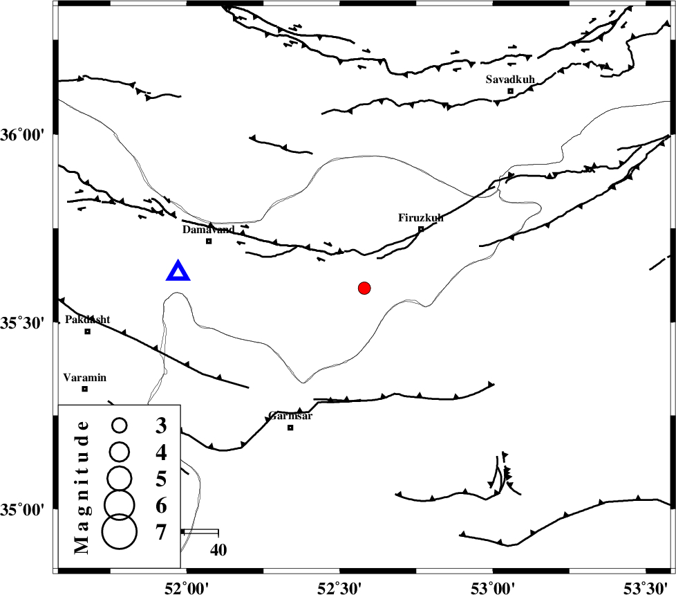
| Location | Lat:35.59 Lon: 52.58 |
| Region | Tehran Province, 24 km South-West of Firuzkuh |
Nearest Cities |
|
| 3 km North of Atashan, Tehran Province | |
| 24 km South West of Firuzkuh, Tehran Province | |
| 24 km South of Arjomand, Tehran Province | |
| 25 km East of Sarbandan, Tehran Province | |
| 25 km South West of Shahrabad, Tehran Province | |
| Depth | 14 km |
| Agency | |
Faults within 150 km: |
|
| MOSHA_F (Length: 234 km) , Distance to epicenter: 12 km | |
| GARMSAR_F (Length: 77 km) , Distance to epicenter: 33 km | |
| ATARI_F (Length: 185 km) , Distance to epicenter: 36 km | |
| Number of Phases | 7 |
| RMS | 0.2 |
| Number of Stations | 6 |
| Error in Latitude | >5.3 km |
| Error in Longitude | 7 km |
| Error in Depth | 6.4 km |
Download waveform in seisan format
to download seisan software Click here
to access information about IIEES stations Click here
Amplitude | ||||||||
| UID | Agency | Station | Component | Amplitude | Period | Arrival Time | Proccessing Time | Signal Clip |
| 58540 | IIEES | THKV | E | 95.2 | 0.15 | 2009-09-11 08:08:45 | 2009-10-25 09:10:00 | n |
| 58541 | IIEES | THKV | N | 82.8 | 0.11 | 2009-09-11 08:08:45 | 2009-10-25 09:10:00 | n |
| 58542 | IIEES | GHVR | N | 77.6 | 0.49 | 2009-09-11 08:08:48 | 2009-10-25 09:10:00 | n |
| 58543 | IIEES | GHVR | E | 108 | 0.37 | 2009-09-11 08:08:48 | 2009-10-25 09:10:00 | n |
| 58544 | IIEES | ASAO | E | 26.2 | 0.67 | 2009-09-11 08:09:10 | 2009-10-25 09:10:00 | n |
Phase | ||||||||||||
| Agency | Station | Component | Phase Type | Phase Quality | First Motion | Observed Arrival Time | Time Residual | Loc. Flag | Input Weight | Distance | Azimuth | |
| IIEES | DAMV | Z | Pg | E | 2009-09-11 08:08:05 | -0.3 | y | 55.3 | 275 | |||
| IIEES | DAMV | E | Sg | E | 2009-09-11 08:08:12 | 0 | y | 55.3 | 275 | |||
| IIEES | CHTH | Z | Pg | E | 2009-09-11 08:08:18 | 0 | y | 136 | 285 | |||
| IIEES | THKV | Z | Pg | E | 2009-09-11 08:08:21 | 0.2 | y | 158 | 284 | |||
| IIEES | GHVR | Z | Pg | E | 2009-09-11 08:08:23 | 0 | y | 173 | 225 | |||
| IIEES | ASAO | Z | Pn | E | 2009-09-11 08:08:35 | -0.1 | y | 260 | 244 | |||
| IIEES | KHMZ | Z | Pn | E | 2009-09-11 08:08:42 | 0.2 | y | 315 | 230 | |||