
Magnitude |
:3.1 |
| Date & Time (UTC) | 2009-09-07 18:53:17.6 |
| Date & Time (Local) | 1388/6/16 23:23:17.6 |
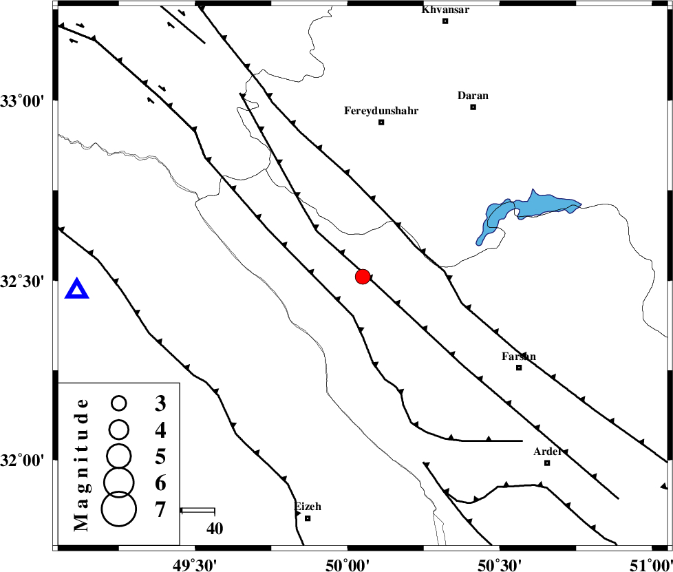
| Location | Lat:32.51 Lon: 50.05 |
| Region | Chaharmahal Bakhtiari Province, 8 km Chelgard |
Nearest Cities |
|
| 8 km North of Chelgard, Chaharmahal Bakhtiari Province | |
| 23 km West of Kukanak, Esfahan Province | |
| 27 km South East of Durak, Chaharmahal Bakhtiari Province | |
| 30 km South West of Ghale? sorkh, Esfahan Province | |
| 37 km West of Organ, Esfahan Province | |
| Depth | 18 km |
| Agency | |
Faults within 150 km: |
|
| ARDAL_F (Length: 170 km) , Distance to epicenter: 4 km | |
| ZARDKUH_F (Length: 139 km) , Distance to epicenter: 12 km | |
| MAIN_ZAGROS_R_F (Length: 1106 km) , Distance to epicenter: 19 km | |
| Number of Phases | 5 |
| RMS | 0 |
| Number of Stations | 5 |
| Error in Latitude | >7.7 km |
| Error in Longitude | 7.2 km |
| Error in Depth | 4.7 km |
Download waveform in seisan format
to download seisan software Click here
to access information about IIEES stations Click here
Amplitude | ||||||||
| UID | Agency | Station | Component | Amplitude | Period | Arrival Time | Proccessing Time | Signal Clip |
| 58509 | IIEES | KHMZ | N | 339 | 0.43 | 2009-09-07 18:54:04 | 2009-10-25 09:10:00 | n |
| 58510 | IIEES | ASAO | E | 131.4 | 0.98 | 2009-09-07 18:54:29 | 2009-10-25 09:10:00 | n |
| 58511 | IIEES | ASAO | N | 120.4 | 1.1 | 2009-09-07 18:54:36 | 2009-10-25 09:10:00 | n |
| 58512 | IIEES | GHVR | N | 126.5 | 0.98 | 2009-09-07 18:54:43 | 2009-10-25 09:10:00 | n |
| 58513 | IIEES | DAMV | E | 36.7 | 1.21 | 2009-09-07 18:55:21 | 2009-10-25 09:10:00 | n |
| 58514 | IIEES | DAMV | N | 26.5 | 0.65 | 2009-09-07 18:55:22 | 2009-10-25 09:10:00 | n |
Phase | ||||||||||||
| Agency | Station | Component | Phase Type | Phase Quality | First Motion | Observed Arrival Time | Time Residual | Loc. Flag | Input Weight | Distance | Azimuth | |
| IIEES | KHMZ | Z | Pg | E | 2009-09-07 18:53:40 | 0 | y | 137 | 357 | |||
| IIEES | ASAO | Z | PN5 | E | 2009-09-07 18:53:53 | 0 | y | 226 | 360 | |||
| IIEES | GHVR | Z | Pg | E | 2009-09-07 18:53:57 | 0 | y | 246 | 27 | |||
| IIEES | NASN | Z | Pn | E | 2009-09-07 18:53:57 | 0 | y | 261 | 82 | |||
| IIEES | DAMV | Z | Pn | E | 2009-09-07 18:54:13 | -0.1 | y | 389 | 27 | |||