
Magnitude |
:3.5 |
| Date & Time (UTC) | 2009-08-07 07:27:34.0 |
| Date & Time (Local) | 1388/5/16 11:57:34.0 |
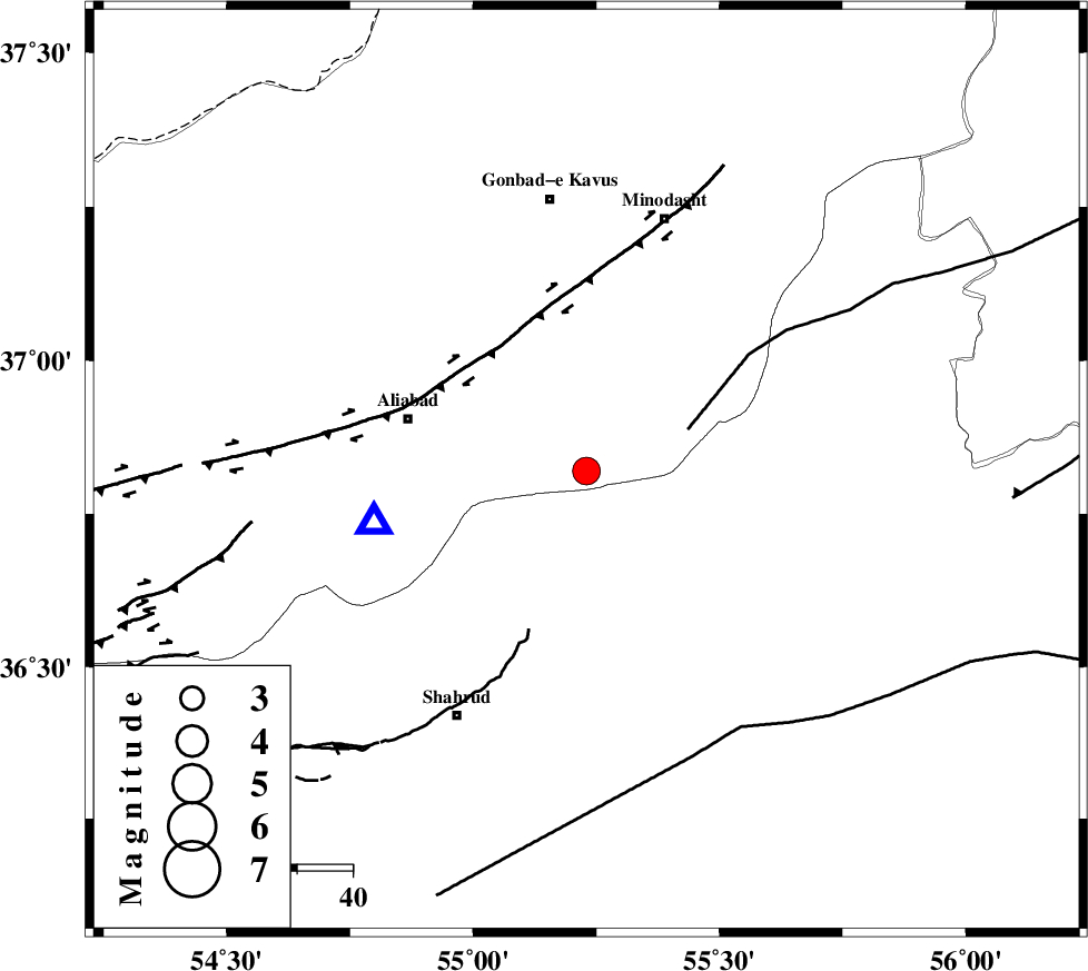
| Location | Lat:36.82 Lon: 55.23 |
| Region | Golestan Province, 22 km South of Ramian |
Nearest Cities |
|
| 18 km North of Kalateh khanj, Semnan Province | |
| 23 km South West of Farsian, Golestan Province | |
| 23 km South of Ramian, Golestan Province | |
| 23 km North East of Qaleh-ye nokharqan, Semnan Province | |
| 27 km South of Khanduz, Golestan Province | |
| Depth | 14 km |
| Agency | |
Faults within 150 km: |
|
| SHAVAR_F (Length: 87 km) , Distance to epicenter: 5 km | |
| ROBATE_QARABIL_F (Length: 168 km) , Distance to epicenter: 20 km | |
| KHAZAR_F (Length: 523 km) , Distance to epicenter: 31 km | |
| Number of Phases | 6 |
| RMS | 0.4 |
| Number of Stations | 5 |
| Error in Latitude | >7.3 km |
| Error in Longitude | 6.4 km |
| Error in Depth | 13.8 km |
Download waveform in seisan format
to download seisan software Click here
to access information about IIEES stations Click here
Amplitude | ||||||||
| UID | Agency | Station | Component | Amplitude | Period | Arrival Time | Proccessing Time | Signal Clip |
| 58414 | IIEES | MRVT | E | 847.7 | 0.31 | 2009-08-07 07:28:16 | 2009-10-27 01:19:00 | n |
| 58415 | IIEES | BJRD | N | 311.5 | 0.99 | 2009-08-07 07:28:41 | 2009-10-27 01:19:00 | n |
| 58416 | IIEES | GHVR | N | 82.3 | 0.88 | 2009-08-07 07:29:56 | 2009-10-27 01:19:00 | n |
| 58417 | IIEES | GHVR | E | 83 | 0.49 | 2009-08-07 07:29:59 | 2009-10-27 01:19:00 | n |
Phase | ||||||||||||
| Agency | Station | Component | Phase Type | Phase Quality | First Motion | Observed Arrival Time | Time Residual | Loc. Flag | Input Weight | Distance | Azimuth | |
| IIEES | SHRO | Z | Pg | E | 2009-08-07 07:27:53 | -0.2 | y | 114 | 142 | |||
| IIEES | MRVT | Z | Pg | E | 2009-08-07 07:27:53 | -0.6 | y | 120 | 39 | |||
| IIEES | BJRD | Z | Pg | E | 2009-08-07 07:28:10 | 0.6 | y | 216 | 63 | |||
| IIEES | DAMV | Z | Pn | E | 2009-08-07 07:28:22 | 0.5 | y | 321 | 247 | |||
| IIEES | DAMV | N | Sg | E | 2009-08-07 07:29:04 | -0.1 | y | 321 | 247 | |||
| IIEES | GHVR | Z | Pn | E | 2009-08-07 07:28:36 | -0.2 | y | 445 | 235 | |||