
Magnitude |
:3.3 |
| Date & Time (UTC) | 2009-08-16 16:56:50.6 |
| Date & Time (Local) | 1388/5/25 21:26:50.6 |
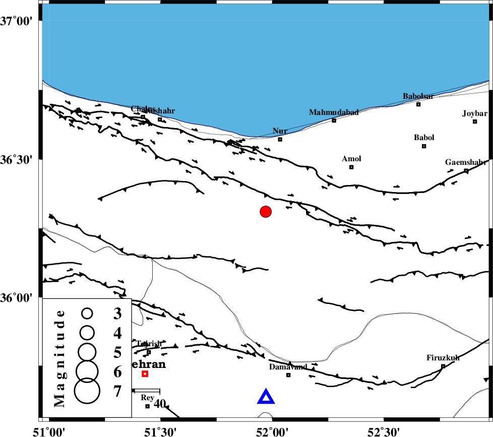
| Location | Lat:36.31 Lon: 51.97 |
| Region | Mazandaran Province, 30 km South of Nur |
Nearest Cities |
|
| 15 km North of Pil, Mazandaran Province | |
| 19 km North East of Baladeh, Mazandaran Province | |
| 23 km South West of Chamestan, Mazandaran Province | |
| 24 km East of Kujur, Mazandaran Province | |
| 26 km South East of Narenj bon, Mazandaran Province | |
| Depth | 14 km |
| Agency | |
Faults within 150 km: |
|
| N_ALBORZ_F (Length: 360 km) , Distance to epicenter: 9 km | |
| KANDOVAN_F (Length: 90 km) , Distance to epicenter: 21 km | |
| KHAZAR_F (Length: 523 km) , Distance to epicenter: 22 km | |
| Number of Phases | 8 |
| RMS | 0.1 |
| Number of Stations | 7 |
| Error in Latitude | >3.1 km |
| Error in Longitude | 3.4 km |
| Error in Depth | 4.1 km |
Download waveform in seisan format
to download seisan software Click here
to access information about IIEES stations Click here
Amplitude | ||||||||
| UID | Agency | Station | Component | Amplitude | Period | Arrival Time | Proccessing Time | Signal Clip |
| 58288 | IIEES | ASAO | N | 145.1 | 0.4 | 2009-08-16 16:58:09 | 2009-10-27 01:20:00 | n |
| 58289 | IIEES | ZNJK | N | 91.7 | 0.4 | 2009-08-16 16:58:16 | 2009-10-27 01:20:00 | n |
| 58290 | IIEES | KHMZ | N | 71 | 0.52 | 2009-08-16 16:58:30 | 2009-10-27 01:20:00 | n |
| 58291 | IIEES | KHMZ | E | 103.8 | 0.72 | 2009-08-16 16:58:32 | 2009-10-27 01:20:00 | n |
Phase | ||||||||||||
| Agency | Station | Component | Phase Type | Phase Quality | First Motion | Observed Arrival Time | Time Residual | Loc. Flag | Input Weight | Distance | Azimuth | |
| IIEES | DAMV | Z | Pg | E | 2009-08-16 16:57:03 | -0.2 | y | 75.2 | 180 | |||
| IIEES | CHTH | Z | Pg | E | 2009-08-16 16:57:05 | -0.1 | y | 87.7 | 240 | |||
| IIEES | THKV | Z | Pg | E | 2009-08-16 16:57:08 | -0.1 | y | 107 | 246 | |||
| IIEES | ASAO | Z | Pn | E | 2009-08-16 16:57:31 | 0 | y | 263 | 223 | |||
| IIEES | ASAO | N | Sg | E | 2009-08-16 16:58:05 | 0.1 | y | 263 | 223 | |||
| IIEES | ZNJK | Z | Pn | E | 2009-08-16 16:57:35 | 0.1 | y | 297 | 279 | |||
| IIEES | KHMZ | Z | Pn | E | 2009-08-16 16:57:40 | 0.1 | y | 338 | 213 | |||
| IIEES | NASN | Z | Pn | E | 2009-08-16 16:57:48 | 0.1 | y | 397 | 169 | |||