
Magnitude |
:2.6 |
| Date & Time (UTC) | 2010-03-20 07:58:46.1 |
| Date & Time (Local) | 1388/12/29 11:28:46.1 |
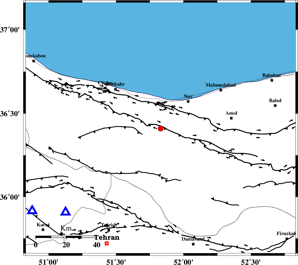
| Location | Lat:36.41 Lon: 51.83 |
| Region | Mazandaran Province, 26 km South-West of Nur |
Nearest Cities |
|
| 10 km North East of Kujur, Mazandaran Province | |
| 14 km South of Narenj bon, Mazandaran Province | |
| 21 km North East of Pul, Mazandaran Province | |
| 23 km South East of Andarud, Mazandaran Province | |
| 24 km North of Baladeh, Mazandaran Province | |
| Depth | 18 km |
| Agency | |
Faults within 150 km: |
|
| N_ALBORZ_F (Length: 360 km) , Distance to epicenter: 2 km | |
| KOJOOR (Length: 75 km) , Distance to epicenter: 13 km | |
| KHAZAR_F (Length: 523 km) , Distance to epicenter: 14 km | |
| Number of Phases | 6 |
| RMS | 0.2 |
| Number of Stations | 4 |
| Error in Latitude | >6.3 km |
| Error in Longitude | 4.5 km |
| Error in Depth | 6.5 km |
Download waveform in seisan format
to download seisan software Click here
to access information about IIEES stations Click here
Amplitude | ||||||||
| UID | Agency | Station | Component | Amplitude | Period | Arrival Time | Proccessing Time | Signal Clip |
| 57370 | IIEES | DAMV | E | 307.1 | 0.3 | 2010-03-20 07:59:12 | 2010-03-20 08:13:00 | n |
| 57371 | IIEES | GHVR | E | 29.8 | 0.45 | 2010-03-20 07:59:56 | 2010-03-20 08:13:00 | n |
Phase | ||||||||||||
| Agency | Station | Component | Phase Type | Phase Quality | First Motion | Observed Arrival Time | Time Residual | Loc. Flag | Input Weight | Distance | Azimuth | |
| IIEES | CHTH | Z | Pg | E | 2010-03-20 07:59:00 | 0.2 | y | 83.9 | 229 | |||
| IIEES | CHTH | E | Sg | E | 2010-03-20 07:59:11 | -0.1 | y | 83.9 | 229 | |||
| IIEES | DAMV | Z | Pg | E | 2010-03-20 07:59:01 | -0.2 | y | 87.1 | 171 | |||
| IIEES | DAMV | N | Sg | E | 2010-03-20 07:59:12 | 0.2 | y | 87.1 | 171 | |||
| IIEES | GHVR | Z | Pn | E | 2010-03-20 07:59:20 | -0.3 | y | 220 | 194 | |||
| IIEES | ASAO | Z | Pn | E | 2010-03-20 07:59:26 | 0.3 | y | 263 | 219 | |||