
Magnitude |
:2.5 |
| Date & Time (UTC) | 2010-02-25 19:35:55.6 |
| Date & Time (Local) | 1388/12/6 23:05:55.6 |
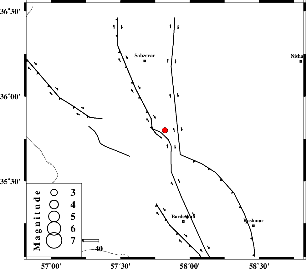
| Location | Lat:35.8 Lon: 57.82 |
| Region | Khorasan(center) Province, 47 km South-East of Sabzevar |
Nearest Cities |
|
| 4 km of Tondak, Khorasan(center) Province | |
| 18 km South of Sheshtamad, Khorasan(center) Province | |
| 19 km North East of Bejdan, Khorasan(center) Province | |
| 33 km North West of Ghaleh meidan, Khorasan(center) Province | |
| 43 km South West of Shamkan, Khorasan(center) Province | |
| Depth | 15 km |
| Agency | |
Faults within 150 km: |
|
| BALHAR_F (Length: 117 km) , Distance to epicenter: 24 km | |
| BIJVARD_F (Length: 83 km) , Distance to epicenter: 42 km | |
| SABZEVAR_F (Length: 81 km) , Distance to epicenter: 49 km | |
| Number of Phases | 6 |
| RMS | 0.1 |
| Number of Stations | 4 |
| Error in Latitude | >1.9 km |
| Error in Longitude | 3.3 km |
| Error in Depth | 6.4 km |
Download waveform in seisan format
to download seisan software Click here
to access information about IIEES stations Click here
Amplitude | ||||||||
| UID | Agency | Station | Component | Amplitude | Period | Arrival Time | Proccessing Time | Signal Clip |
| 56310 | IIEES | TABS | N | 30.7 | 0.6 | 2010-02-25 19:37:13 | 2010-02-25 07:48:00 | n |
| 56311 | IIEES | SHRT | N | 11 | 0.44 | 2010-02-25 19:37:41 | 2010-02-25 07:48:00 | n |
| 56312 | IIEES | SHRT | E | 17 | 0.56 | 2010-02-25 19:37:43 | 2010-02-25 07:48:00 | n |
Phase | ||||||||||||
| Agency | Station | Component | Phase Type | Phase Quality | First Motion | Observed Arrival Time | Time Residual | Loc. Flag | Input Weight | Distance | Azimuth | |
| IIEES | SHRD | Z | Pn | E | 2010-02-25 19:36:23 | 0 | y | 165 | 278 | |||
| IIEES | SHRD | Z | Sg | E | 2010-02-25 19:36:42 | 0.1 | y | 165 | 278 | |||
| IIEES | BJRD | N | Pn | E | 2010-02-25 19:36:29 | -0.1 | y | 214 | 350 | |||
| IIEES | TABS | Z | Pn | E | 2010-02-25 19:36:33 | -0.1 | y | 247 | 195 | |||
| IIEES | TABS | E | Sg | E | 2010-02-25 19:37:05 | -0.1 | y | 247 | 195 | |||
| IIEES | SHRT | Z | Pn | E | 2010-02-25 19:36:44 | 0.2 | y | 329 | 136 | |||