
Magnitude |
:3.4 |
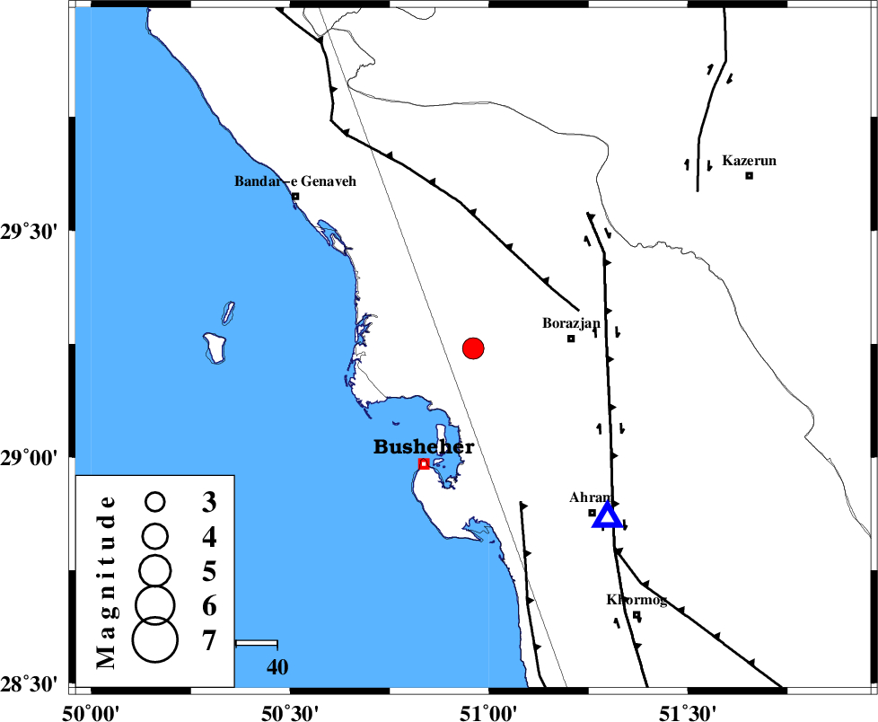
| Date & Time (UTC) | 2010-02-25 15:41:50.0 |
| Date & Time (Local) | 1388/12/6 19:11:50.0 |
| Location | Lat:29.24 Lon: 50.96 |
| Region | Bushehr Province, 24 km West of Borazjan |
Nearest Cities |
|
| 5 km of Kareband, Bushehr Province | |
| 6 km of Shabankareh, Bushehr Province | |
| 12 km West of Ziyarat, Bushehr Province | |
| 22 km South West of Saedabad, Bushehr Province | |
| 24 km West of Borazjan, Bushehr Province | |
| Depth | 15 km |
| Agency | |
Faults within 150 km: |
|
| ZFF3 (Length: 125 km) , Distance to epicenter: 24 km | |
| BORAZJAN_F (Length: 168 km) , Distance to epicenter: 33 km | |
| ZFF2 (Length: 84 km) , Distance to epicenter: 39 km | |
| Number of Phases | 5 |
| RMS | 0.1 |
| Number of Stations | 3 |
| Error in Latitude | >4.9 km |
| Error in Longitude | 6.5 km |
| Error in Depth | 7.4 km |
Download waveform in seisan format
to download seisan software Click here
to access information about IIEES stations Click here
Amplitude | ||||||||
| UID | Agency | Station | Component | Amplitude | Period | Arrival Time | Proccessing Time | Signal Clip |
| 56270 | IIEES | GHIR | E | 311.5 | 0.48 | 2010-02-25 15:43:00 | 2010-02-25 04:11:00 | n |
| 56271 | IIEES | GHIR | N | 275.4 | 0.52 | 2010-02-25 15:43:02 | 2010-02-25 04:11:00 | n |
Phase | ||||||||||||
| Agency | Station | Component | Phase Type | Phase Quality | First Motion | Observed Arrival Time | Time Residual | Loc. Flag | Input Weight | Distance | Azimuth | |
| IIEES | GHIR | E | Pn | E | 2010-02-25 15:42:25 | 0 | y | 224 | 118 | |||
| IIEES | GHIR | E | Sg | E | 2010-02-25 15:42:53 | 0 | y | 224 | 118 | |||
| IIEES | ASAO | Z | Pn | E | 2010-02-25 15:43:11 | -0.2 | y | 596 | 352 | |||
| IIEES | ASAO | Z | Sn | 2010-02-25 15:44:11 | 0.1 | y | 596 | 352 | ||||
| IIEES | SNGE | Z | Pn | E | 2010-02-25 15:43:29 | 0.2 | y | 734 | 333 | |||