
Magnitude |
:3.1 |
| Date & Time (UTC) | 2010-02-21 16:00:07.9 |
| Date & Time (Local) | 1388/12/2 19:30:07.9 |
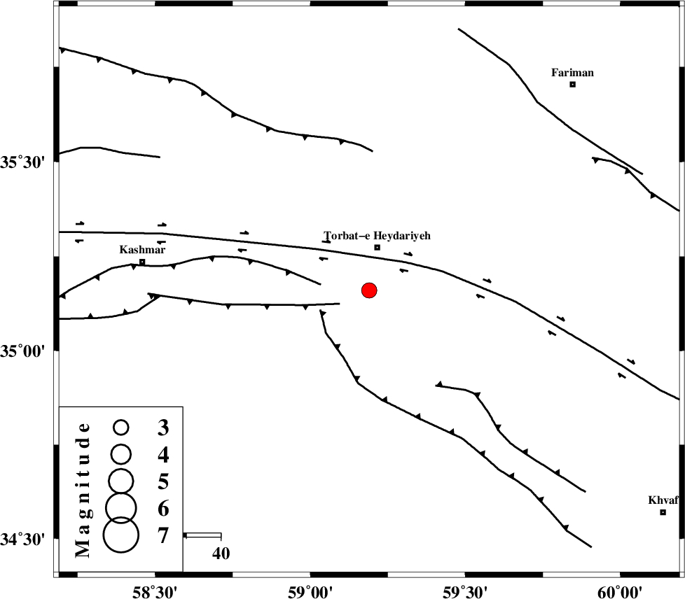
| Location | Lat:35.16 Lon: 59.19 |
| Region | Khorasan(center) Province, 13 km South of Torbat-e heydariyeh |
Nearest Cities |
|
| 5 km of Booriabad, Khorasan(center) Province | |
| 13 km South of Torbat-e heydariyeh, Khorasan(center) Province | |
| 14 km East of Shadmehr, Khorasan(center) Province | |
| 16 km South of Manzar, Khorasan(center) Province | |
| 24 km South West of Karizak-e nagahani, Khorasan(center) Province | |
| Depth | 15 km |
| Agency | |
Faults within 150 km: |
|
| DUGHABAD_F (Length: 62 km) , Distance to epicenter: 9 km | |
| DORUNEH_F (Length: 713 km) , Distance to epicenter: 13 km | |
| KASHMAR_F (Length: 91 km) , Distance to epicenter: 14 km | |
| Number of Phases | 5 |
| RMS | 0 |
| Number of Stations | 3 |
| Error in Latitude | >2.2 km |
| Error in Longitude | 1.5 km |
| Error in Depth | 5.3 km |
Download waveform in seisan format
to download seisan software Click here
to access information about IIEES stations Click here
Amplitude | ||||||||
| UID | Agency | Station | Component | Amplitude | Period | Arrival Time | Proccessing Time | Signal Clip |
| 55970 | IIEES | SHRT | N | 201.4 | 0.72 | 2010-02-21 16:01:13 | 2010-02-21 07:02:00 | n |
| 55971 | IIEES | SHRT | E | 254.8 | 0.64 | 2010-02-21 16:01:15 | 2010-02-21 07:02:00 | n |
| 55972 | IIEES | TABS | E | 97 | 0.32 | 2010-02-21 16:01:24 | 2010-02-21 07:02:00 | n |
Phase | ||||||||||||
| Agency | Station | Component | Phase Type | Phase Quality | First Motion | Observed Arrival Time | Time Residual | Loc. Flag | Input Weight | Distance | Azimuth | |
| IIEES | SHRT | Z | Pg | E | 2010-02-21 16:00:40 | 0 | y | 196 | 149 | |||
| IIEES | SHRT | E | Sg | E | 2010-02-21 16:01:03 | 0 | y | 196 | 149 | |||
| IIEES | TABS | Z | Pn | E | 2010-02-21 16:00:47 | 0 | y | 253 | 229 | |||
| IIEES | TABS | N | Sg | E | 2010-02-21 16:01:19 | 0 | y | 253 | 229 | |||
| IIEES | BJRD | Z | P | E | 2010-02-21 16:00:55 | 0 | y | 324 | 331 | |||