
Magnitude |
:2.8 |
| Date & Time (UTC) | 2010-02-18 15:21:13.2 |
| Date & Time (Local) | 1388/11/29 18:51:13.2 |
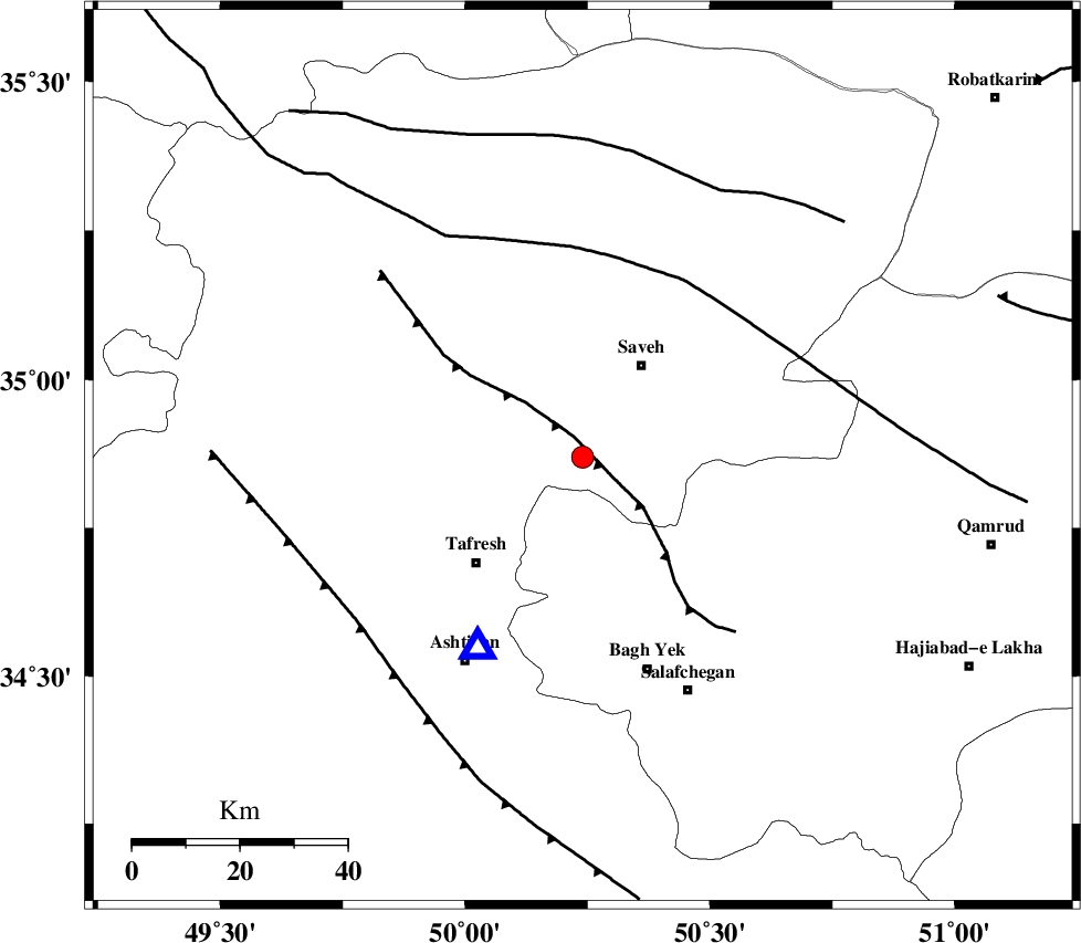
| Location | Lat:34.87 Lon: 50.24 |
| Region | 20 km South-West of Saveh, Markazi Province |
Nearest Cities |
|
| 10 km of Yalabad, Markazi Province | |
| 13 km West of Qareh chay, Markazi Province | |
| 16 km North East of Khanak, Markazi Province | |
| 20 km South West of Saveh, Markazi Province | |
| 28 km South East of Qeytaniyeh, Markazi Province | |
| Depth | 14 km |
| Agency | |
Faults within 150 km: |
|
| INDES_F (Length: 98 km) , Distance to epicenter: 4 km | |
| KUSHK_E_NOSRAT_F (Length: 230 km) , Distance to epicenter: 37 km | |
| TAFRESH_F (Length: 117 km) , Distance to epicenter: 52 km | |
| Number of Phases | 5 |
| RMS | 0.1 |
| Number of Stations | 5 |
| Error in Latitude | >1.6 km |
| Error in Longitude | 2.3 km |
| Error in Depth | 3.5 km |
Download waveform in seisan format
to download seisan software Click here
to access information about IIEES stations Click here
Amplitude | ||||||||
| UID | Agency | Station | Component | Amplitude | Period | Arrival Time | Proccessing Time | Signal Clip |
| 55610 | IIEES | GHVR | N | 216.4 | 0.6 | 2010-02-18 15:21:54 | 2010-02-18 03:46:00 | n |
| 55611 | IIEES | GHVR | E | 369 | 0.8 | 2010-02-18 15:22:01 | 2010-02-18 03:46:00 | n |
| 55612 | IIEES | KHMZ | E | 248 | 0.28 | 2010-02-18 15:21:52 | 2010-02-18 03:46:00 | n |
| 55613 | IIEES | KHMZ | N | 261.1 | 0.44 | 2010-02-18 15:21:53 | 2010-02-18 03:46:00 | n |
| 55614 | IIEES | ZNJK | N | 40.8 | 0.56 | 2010-02-18 15:22:26 | 2010-02-18 03:46:00 | n |
| 55615 | IIEES | ZNJK | E | 42.4 | 0.44 | 2010-02-18 15:22:27 | 2010-02-18 03:46:00 | n |
Phase | ||||||||||||
| Agency | Station | Component | Phase Type | Phase Quality | First Motion | Observed Arrival Time | Time Residual | Loc. Flag | Input Weight | Distance | Azimuth | |
| IIEES | ASAO | Z | Pg | E | 2010-02-18 15:21:20 | 0 | y | 40.7 | 210 | |||
| IIEES | GHVR | Z | Pg | E | 2010-02-18 15:21:30 | -0.1 | y | 101 | 115 | |||
| IIEES | ZNJK | Z | Pn | E | 2010-02-18 15:21:51 | 0 | y | 245 | 325 | |||
| IIEES | ZNJK | N | Sg | E | 2010-02-18 15:22:22 | 0 | y | 245 | 325 | |||
| IIEES | NASN | Z | Pn | E | 2010-02-18 15:22:02 | 0.1 | y | 330 | 133 | |||