
Magnitude |
:2.7 |
| Date & Time (UTC) | 2010-02-06 18:00:18.4 |
| Date & Time (Local) | 1388/11/17 21:30:18.4 |
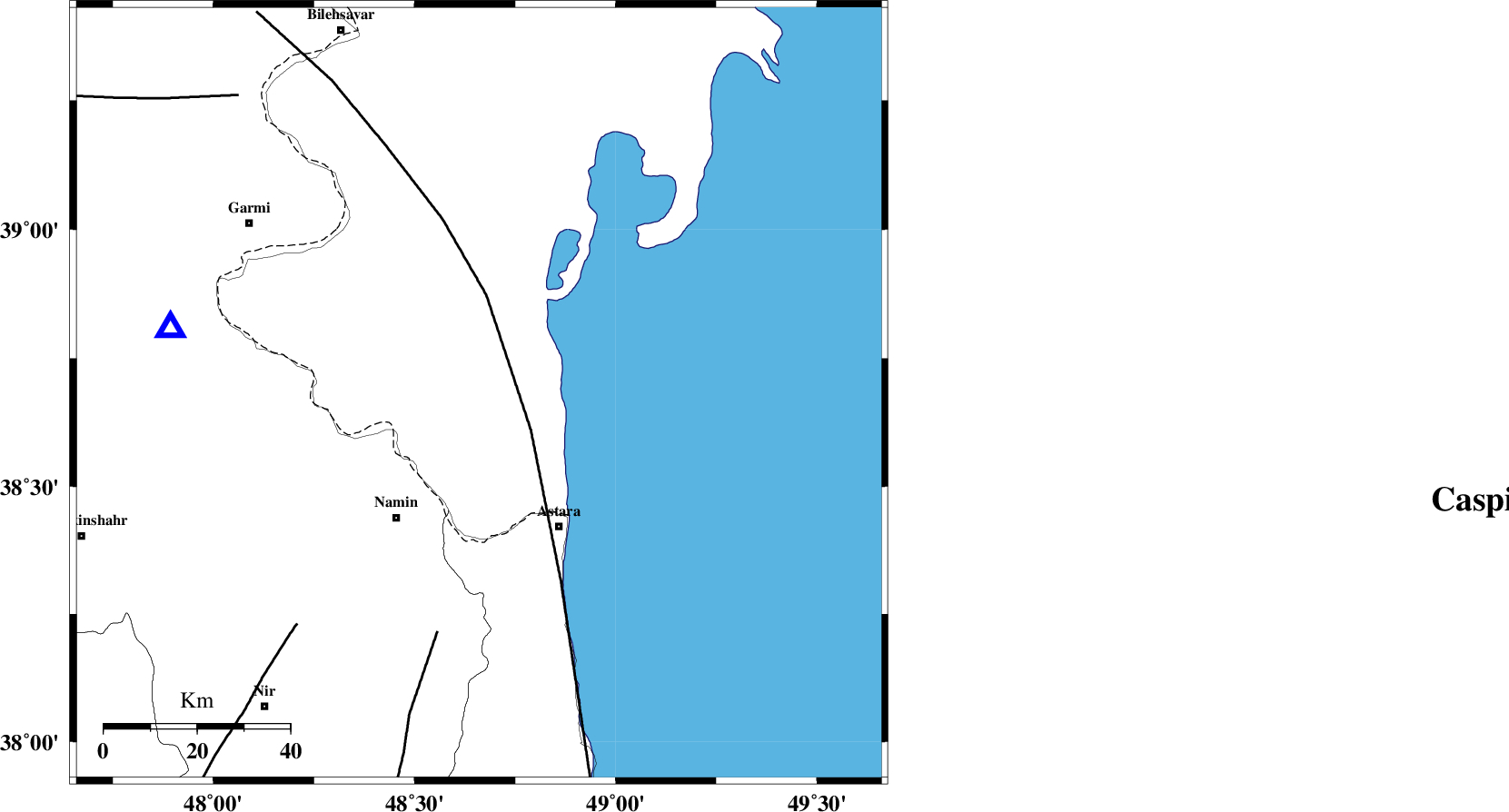
| Location | Lat:38.68 Lon: 48.66 |
| Region | 32 km North-East of Namin, Ardebil Province |
Nearest Cities |
|
| 27 km North East of Anbaran, Ardebil Province | |
| 30 km North East of Lurun, Ardebil Province | |
| 32 km North East of Khaneh zeinian, Ardebil Province | |
| 32 km North East of Namin, Ardebil Province | |
| 33 km North of Kiladeh, Gilan Province | |
| Depth | 14 km |
| Agency | |
Faults within 150 km: |
|
| TALESH_F (Length: 258 km) , Distance to epicenter: 14 km | |
| SANGAVAR_F (Length: 61 km) , Distance to epicenter: 52 km | |
| BOZQUSH (Length: 70 km) , Distance to epicenter: 63 km | |
| Number of Phases | 4 |
| RMS | 0.1 |
| Number of Stations | 5 |
| Error in Latitude | >3.7 km |
| Error in Longitude | 8.1 km |
| Error in Depth | 10.7 km |
Download waveform in seisan format
to download seisan software Click here
to access information about IIEES stations Click here
Amplitude | ||||||||
| UID | Agency | Station | Component | Amplitude | Period | Arrival Time | Proccessing Time | Signal Clip |
| 55074 | IIEES | ZNJK | E | 31.9 | 0.44 | 2010-02-06 18:01:25 | 2010-02-06 06:27:00 | n |
| 55075 | IIEES | ZNJK | N | 39.5 | 0.28 | 2010-02-06 18:01:26 | 2010-02-06 06:27:00 | n |
| 55076 | IIEES | MAKU | N | 11.1 | 0.56 | 2010-02-06 18:01:59 | 2010-02-06 06:27:00 | n |
| 55077 | IIEES | CHTH | N | 10.1 | 0.32 | 2010-02-06 18:01:56 | 2010-02-06 06:27:00 | n |
| 55078 | IIEES | MRVT | N | 8.4 | 0.28 | 2010-02-06 18:02:54 | 2010-02-06 06:27:00 | n |
| 55079 | IIEES | MRVT | E | 9.9 | 0.2 | 2010-02-06 18:02:56 | 2010-02-06 06:27:00 | n |
Phase | ||||||||||||
| Agency | Station | Component | Phase Type | Phase Quality | First Motion | Observed Arrival Time | Time Residual | Loc. Flag | Input Weight | Distance | Azimuth | |
| IIEES | GRMI | Z | Pg | E | 2010-02-06 18:00:30 | -0.1 | y | 68.3 | 283 | |||
| IIEES | ZNJK | E | Pn | E | 2010-02-06 18:00:54 | 0.2 | y | 223 | 179 | |||
| IIEES | ZNJK | N | Sg | E | 2010-02-06 18:01:21 | -0.1 | y | 223 | 179 | |||
| IIEES | MRVT | Z | Pn | E | 2010-02-06 18:01:48 | -0.1 | y | 660 | 98 | |||