
Magnitude |
:3.4 |
| Date & Time (UTC) | 2010-01-30 13:50:04.2 |
| Date & Time (Local) | 1388/11/10 17:20:04.2 |
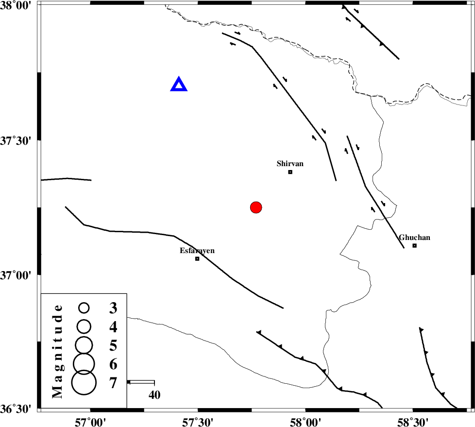
| Location | Lat:37.25 Lon: 57.77 |
| Region | 20 km South-West of Shirvan, Khorasan(north) Province |
Nearest Cities |
|
| 8 km of Zavarom, Khorasan(north) Province | |
| 12 km North West of Geliyan, Khorasan(north) Province | |
| 20 km South West of Shirvan, Khorasan(north) Province | |
| 24 km South West of Ziyarat, Khorasan(north) Province | |
| 25 km North West of Maviyan, Khorasan(center) Province | |
| Depth | 14 km |
| Agency | |
Faults within 150 km: |
|
| ESFARAYEN_F (Length: 111 km) , Distance to epicenter: 31 km | |
| BAGHAN_GERMAB_F (Length: 79 km) , Distance to epicenter: 35 km | |
| GHUCHAN_F (Length: 50 km) , Distance to epicenter: 46 km | |
| Number of Phases | 4 |
| RMS | 0.1 |
| Number of Stations | 3 |
| Error in Latitude | >2.4 km |
| Error in Longitude | 16.2 km |
| Error in Depth | 19.1 km |
Download waveform in seisan format
to download seisan software Click here
to access information about IIEES stations Click here
Amplitude | ||||||||
| UID | Agency | Station | Component | Amplitude | Period | Arrival Time | Proccessing Time | Signal Clip |
| 54650 | IIEES | BJRD | E | 1691.8 | 0.25 | 2010-01-30 13:50:24 | 2010-01-30 02:05:00 | n |
| 54651 | IIEES | MRVT | N | 619.7 | 0.23 | 2010-01-30 13:50:54 | 2010-01-30 02:05:00 | n |
| 54652 | IIEES | MRVT | E | 710.4 | 0.34 | 2010-01-30 13:50:55 | 2010-01-30 02:05:00 | n |
Phase | ||||||||||||
| Agency | Station | Component | Phase Type | Phase Quality | First Motion | Observed Arrival Time | Time Residual | Loc. Flag | Input Weight | Distance | Azimuth | |
| IIEES | BJRD | Z | Pg | E | 2010-01-30 13:50:14 | 0.1 | y | 59 | 328 | |||
| IIEES | BJRD | N | Sg | E | 2010-01-30 13:50:22 | -0.1 | y | 59 | 328 | |||
| IIEES | MRVT | Z | P | E | 2010-01-30 13:50:29 | 0.2 | y | 155 | 287 | |||
| IIEES | SHRD | Z | Pg | E | 2010-01-30 13:50:38 | -0.1 | y | 209 | 229 | |||