
Magnitude |
:3 |
| Date & Time (UTC) | 2010-01-08 02:28:18.5 |
| Date & Time (Local) | 1388/10/18 05:58:18.5 |
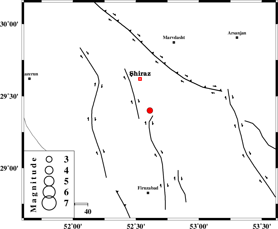
| Location | Lat:29.4 Lon: 52.61 |
| Region | 25 km South of Shiraz, Fars Province |
Nearest Cities |
|
| 14 km South of Soltanabad, Fars Province | |
| 17 km North of Tasuj, Fars Province | |
| 21 km North West of Maharlu, Fars Province | |
| 24 km North West of Akbarabad, Fars Province | |
| 25 km South of Shiraz, Fars Province | |
| Depth | 46 km |
| Agency | |
Faults within 150 km: |
|
| SABZ_PUSHAN_F_Z1 (Length: 69 km) , Distance to epicenter: 5 km | |
| SABZ_PUSHAN_F_Z3 (Length: 37 km) , Distance to epicenter: 10 km | |
| HZF3 (Length: 197 km) , Distance to epicenter: 36 km | |
| Number of Phases | 6 |
| RMS | 0.4 |
| Number of Stations | 3 |
| Error in Latitude | >3.8 km |
| Error in Longitude | 8.7 km |
| Error in Depth | 8.9 km |
Download waveform in seisan format
to download seisan software Click here
to access information about IIEES stations Click here
Amplitude | ||||||||
| UID | Agency | Station | Component | Amplitude | Period | Arrival Time | Proccessing Time | Signal Clip |
| 53663 | IIEES | GHIR | N | 207.5 | 0.52 | 2010-01-08 02:29:07 | 2010-01-08 02:42:00 | n |
| 53664 | IIEES | GHIR | E | 199.9 | 0.52 | 2010-01-08 02:29:08 | 2010-01-08 02:42:00 | n |
| 53665 | IIEES | KRBR | N | 40.8 | 0.64 | 2010-01-08 02:30:15 | 2010-01-08 02:42:00 | n |
| 53666 | IIEES | KRBR | E | 49.9 | 0.68 | 2010-01-08 02:30:20 | 2010-01-08 02:42:00 | n |
Phase | ||||||||||||
| Agency | Station | Component | Phase Type | Phase Quality | First Motion | Observed Arrival Time | Time Residual | Loc. Flag | Input Weight | Distance | Azimuth | |
| IIEES | GHIR | Z | Pn | E | 2010-01-08 02:28:37 | -0.8 | y | 129 | 163 | |||
| IIEES | GHIR | N | Sg | E | 2010-01-08 02:28:57 | 0.6 | y | 129 | 163 | |||
| IIEES | NASN | Z | Pn | E | 2010-01-08 02:29:10 | 0.2 | y | 377 | 3 | |||
| IIEES | NASN | E | Sg | E | 2010-01-08 02:30:02 | 0.1 | y | 377 | 3 | |||
| IIEES | KRBR | Z | Pn | E | 2010-01-08 02:29:13 | 0 | y | 407 | 80 | |||
| IIEES | KRBR | E | Sg | E | 2010-01-08 02:30:09 | -0.1 | y | 407 | 80 | |||