
Magnitude |
:3.3 |
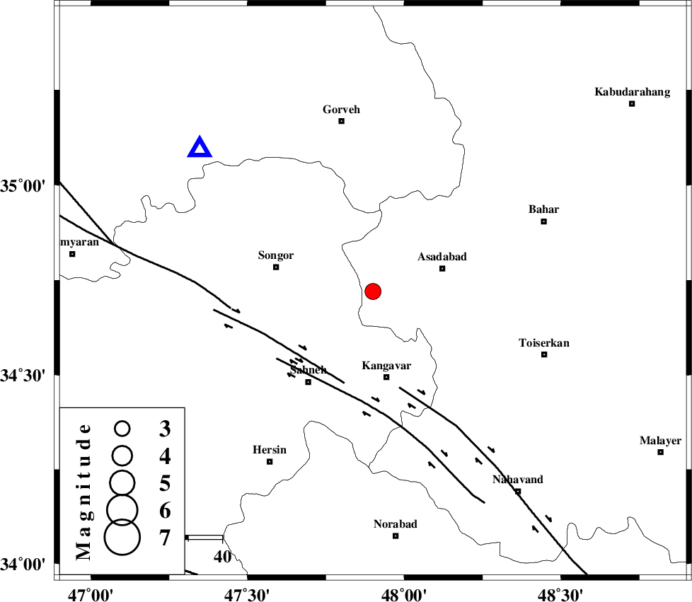
| Date & Time (UTC) | 2009-04-24 14:08:52.3 |
| Date & Time (Local) | 1388/2/4 18:38:52.3 |
| Location | Lat:34.72 Lon: 47.9 |
| Region | 21 km West of Asad Abad, Hamedan Province |
Nearest Cities |
|
| 5 km of Ajin, Hamedan Province | |
| 9 km North of Musaabad, Hamedan Province | |
| 12 km West of Yoosefabad, Hamedan Province | |
| 13 km North East of Farsinaj, Kermanshah Province | |
| 15 km North West of Jannatabad, Hamedan Province | |
| Depth | 37 km |
| Agency | |
Faults within 150 km: |
|
| DINEHVAR_F (Length: 46 km) , Distance to epicenter: 28 km | |
| NAHAVAND_F (Length: 102 km) , Distance to epicenter: 29 km | |
| SAHANEH_F (Length: 77 km) , Distance to epicenter: 32 km | |
| Number of Phases | 9 |
| RMS | 0.3 |
| Number of Stations | 8 |
| Error in Latitude | >3.5 km |
| Error in Longitude | 10.4 km |
| Error in Depth | 8.1 km |
Download waveform in seisan format
to download seisan software Click here
to access information about IIEES stations Click here
Amplitude | ||||||||
| UID | Agency | Station | Component | Amplitude | Period | Arrival Time | Proccessing Time | Signal Clip |
| 52531 | IIEES | KHMZ | E | 271.6 | 0.07 | 2009-04-24 14:09:59 | 2009-07-13 01:52:00 | n |
| 52532 | IIEES | KHMZ | N | 216.1 | 1 | 2009-04-24 14:10:09 | 2009-07-13 01:52:00 | n |
| 52533 | IIEES | GHVR | N | 111.8 | 0.53 | 2009-04-24 14:10:31 | 2009-07-13 01:52:00 | n |
Phase | ||||||||||||
| Agency | Station | Component | Phase Type | Phase Quality | First Motion | Observed Arrival Time | Time Residual | Loc. Flag | Input Weight | Distance | Azimuth | |
| IIEES | ASAO | Z | Pg | E | 2009-04-24 14:09:24 | 0 | y | 196 | 95 | |||
| IIEES | KHMZ | Z | PN5 | E | 2009-04-24 14:09:24 | -0.4 | y | 219 | 119 | |||
| IIEES | ZNJK | Z | PN5 | E | 2009-04-24 14:09:26 | -0.2 | y | 228 | 18 | |||
| IIEES | SHGR | Z | Pn | E | 2009-04-24 14:09:35 | 0.2 | y | 301 | 164 | |||
| IIEES | SHGR | N | Sg | E | 2009-04-24 14:10:14 | 0 | y | 301 | 164 | |||
| IIEES | THKV | Z | Pn | E | 2009-04-24 14:09:36 | 0.5 | y | 302 | 63 | |||
| IIEES | GHVR | Z | Pn | E | 2009-04-24 14:09:36 | 0.3 | y | 308 | 94 | |||
| IIEES | CHTH | Z | Pn | E | 2009-04-24 14:09:37 | -0.2 | y | 322 | 65 | |||
| IIEES | NASN | Z | Pn | E | 2009-04-24 14:10:00 | -0.3 | y | 502 | 114 | |||