
Magnitude |
:3.9 |
| Date & Time (UTC) | 2009-03-24 15:45:10.0 |
| Date & Time (Local) | 1388/1/4 20:15:10.0 |
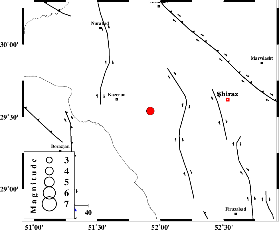
| Location | Lat:29.54 Lon: 51.92 |
| Region | 26 km East of Kazerun, Fars Province |
Nearest Cities |
|
| 7 km of Kalani, Fars Province | |
| 24 km North West of Richi, Fars Province | |
| 25 km North of Dadin-e olia, Fars Province | |
| 25 km East of Mehranjan, Fars Province | |
| 27 km East of Kazerun, Fars Province | |
| Depth | 46 km |
| Agency | |
Faults within 150 km: |
|
| KAREBASS_F (Length: 98 km) , Distance to epicenter: 27 km | |
| KAZERUN_F (Length: 96 km) , Distance to epicenter: 39 km | |
| SABZ_PUSHAN_F_Z3 (Length: 37 km) , Distance to epicenter: 50 km | |
| Number of Phases | 7 |
| RMS | 0.3 |
| Number of Stations | 5 |
| Error in Latitude | >3.1 km |
| Error in Longitude | 9.4 km |
| Error in Depth | 5.7 km |
Download waveform in seisan format
to download seisan software Click here
to access information about IIEES stations Click here
Amplitude | ||||||||
| UID | Agency | Station | Component | Amplitude | Period | Arrival Time | Proccessing Time | Signal Clip |
| 52265 | IIEES | GHIR | N | 1294.7 | 0.6 | 2009-03-24 15:46:05 | 2009-06-27 08:52:00 | n |
| 52266 | IIEES | GHIR | E | 2032.8 | 0.43 | 2009-03-24 15:46:06 | 2009-06-27 08:52:00 | n |
| 52267 | IIEES | KRBR | E | 124.5 | 0.35 | 2009-03-24 15:47:33 | 2009-06-27 08:52:00 | n |
| 52268 | IIEES | KRBR | N | 128.3 | 0.88 | 2009-03-24 15:47:36 | 2009-06-27 08:52:00 | n |
| 52269 | IIEES | BNDS | E | 73.6 | 0.73 | 2009-03-24 15:47:25 | 2009-06-27 08:52:00 | n |
Phase | ||||||||||||
| Agency | Station | Component | Phase Type | Phase Quality | First Motion | Observed Arrival Time | Time Residual | Loc. Flag | Input Weight | Distance | Azimuth | |
| IIEES | GHIR | Z | Pg | E | 2009-03-24 15:45:38 | -0.3 | y | 174 | 143 | |||
| IIEES | GHIR | N | Sg | E | 2009-03-24 15:46:00 | 0.3 | y | 174 | 143 | |||
| IIEES | NASN | Z | Pn | E | 2009-03-24 15:46:00 | -0.3 | y | 371 | 13 | |||
| IIEES | NASN | E | Sg | E | 2009-03-24 15:46:52 | 0.1 | y | 371 | 13 | |||
| IIEES | KRBR | Z | Pn | E | 2009-03-24 15:46:13 | 0.1 | y | 471 | 83 | |||
| IIEES | BNDS | Z | Pn | E | 2009-03-24 15:46:13 | -0.2 | y | 480 | 119 | |||
| IIEES | KHMZ | Z | Pn | E | 2009-03-24 15:46:17 | 0.4 | y | 501 | 339 | |||