
Magnitude |
:3.5 |
| Date & Time (UTC) | 2009-03-22 18:11:06.2 |
| Date & Time (Local) | 1388/1/2 22:41:06.2 |
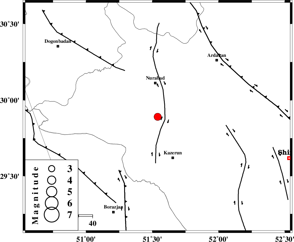
| Location | Lat:29.89 Lon: 51.54 |
| Region | 24 km South of Nurabad, Fars Province |
Nearest Cities |
|
| 13 km North of Seyyed hasan, Fars Province | |
| 19 km North West of Nodan, Fars Province | |
| 22 km South of Gachgaran, Fars Province | |
| 24 km North of Deris, Fars Province | |
| 25 km South of Nurabad, Fars Province | |
| Depth | 15 km |
| Agency | |
Faults within 150 km: |
|
| KAZERUN_F (Length: 96 km) , Distance to epicenter: 6 km | |
| MISHAN_F (Length: 76 km) , Distance to epicenter: 41 km | |
| BORAZJAN_F (Length: 168 km) , Distance to epicenter: 48 km | |
| Number of Phases | 7 |
| RMS | 0.3 |
| Number of Stations | 7 |
| Error in Latitude | >5.5 km |
| Error in Longitude | 10.6 km |
| Error in Depth | 0 km |
Download waveform in seisan format
to download seisan software Click here
to access information about IIEES stations Click here
Amplitude | ||||||||
| UID | Agency | Station | Component | Amplitude | Period | Arrival Time | Proccessing Time | Signal Clip |
| 52245 | IIEES | GHIR | N | 452.1 | 0.52 | 2009-03-22 18:12:28 | 2009-06-27 08:52:00 | n |
| 52246 | IIEES | GHIR | E | 391.1 | 0.48 | 2009-03-22 18:12:29 | 2009-06-27 08:52:00 | n |
| 52247 | IIEES | KRBR | N | 38.2 | 0.6 | 2009-03-22 18:13:34 | 2009-06-27 08:52:00 | n |
| 52248 | IIEES | KRBR | E | 46.2 | 0.76 | 2009-03-22 18:13:44 | 2009-06-27 08:52:00 | n |
Phase | ||||||||||||
| Agency | Station | Component | Phase Type | Phase Quality | First Motion | Observed Arrival Time | Time Residual | Loc. Flag | Input Weight | Distance | Azimuth | |
| IIEES | GHIR | Z | Pg | E | 2009-03-22 18:11:43 | -0.1 | y | 227 | 141 | |||
| IIEES | NASN | Z | Pn | E | 2009-03-22 18:11:56 | -0.4 | y | 344 | 20 | |||
| IIEES | KRBR | Z | Pn | E | 2009-03-22 18:12:17 | 0.5 | y | 504 | 88 | |||
| IIEES | GHVR | Z | Pn | E | 2009-03-22 18:12:17 | 0.5 | y | 510 | 357 | |||
| IIEES | BNDS | Z | Pn | E | 2009-03-22 18:12:19 | -0.2 | y | 530 | 120 | |||
| IIEES | DAMV | Z | Pn | E | 2009-03-22 18:12:32 | -0.4 | y | 638 | 3 | |||
| IIEES | SNGE | Z | Pn | E | 2009-03-22 18:12:40 | 0.2 | y | 699 | 327 | |||