
Magnitude |
:3.4 |
| Date & Time (UTC) | 2009-03-19 13:48:35.3 |
| Date & Time (Local) | 1387/12/29 17:18:35.3 |
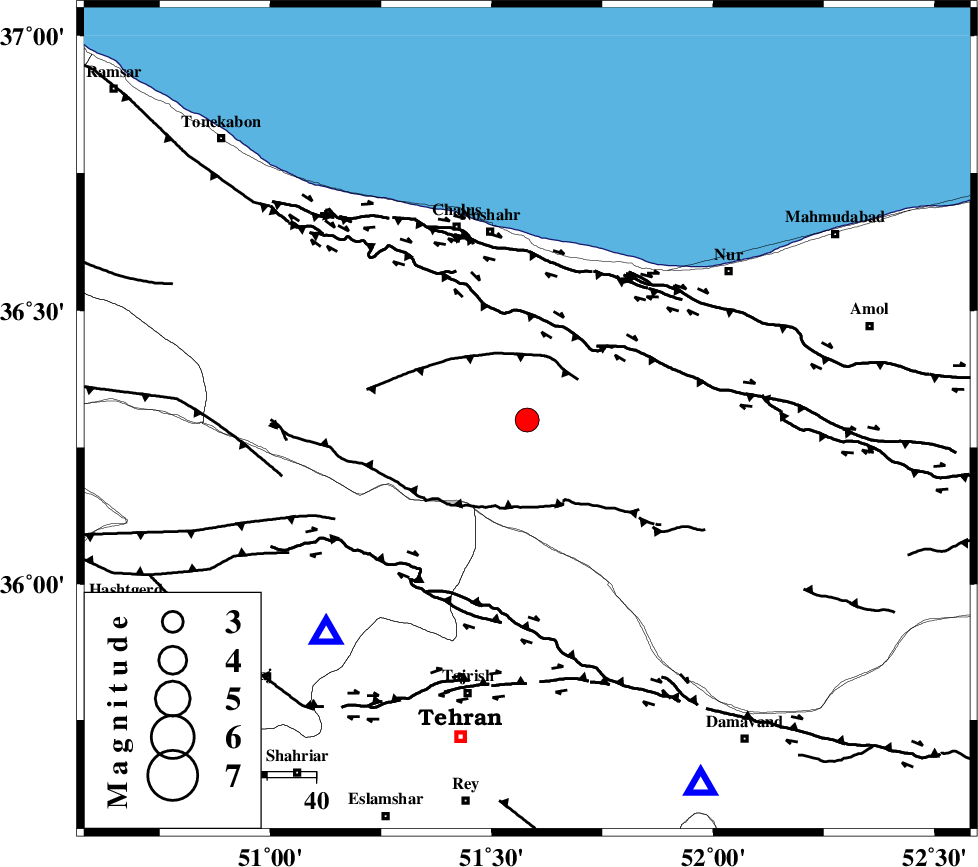
| Location | Lat:36.3 Lon: 51.58 |
| Region | 38 km South of Nowshahr, Mazandaran Province |
Nearest Cities |
|
| 7 km North of Void, Mazandaran Province | |
| 11 km South of Pul, Mazandaran Province | |
| 15 km West of Kujur, Mazandaran Province | |
| 23 km North West of Baladeh, Mazandaran Province | |
| 25 km North East of Pol-e zanguleh, Mazandaran Province | |
| Depth | 14 km |
| Agency | |
Faults within 150 km: |
|
| KOJOOR (Length: 75 km) , Distance to epicenter: 13 km | |
| KANDOVAN_F (Length: 90 km) , Distance to epicenter: 18 km | |
| N_ALBORZ_F (Length: 360 km) , Distance to epicenter: 19 km | |
| Number of Phases | 7 |
| RMS | 0.3 |
| Number of Stations | 6 |
| Error in Latitude | >6.5 km |
| Error in Longitude | 8.4 km |
| Error in Depth | 9.4 km |
Download waveform in seisan format
to download seisan software Click here
to access information about IIEES stations Click here
Amplitude | ||||||||
| UID | Agency | Station | Component | Amplitude | Period | Arrival Time | Proccessing Time | Signal Clip |
| 52212 | IIEES | GHVR | E | 330.6 | 0.44 | 2009-03-19 13:49:36 | 2009-06-27 08:52:00 | n |
| 52213 | IIEES | GHVR | N | 360.6 | 0.56 | 2009-03-19 13:49:43 | 2009-06-27 08:52:00 | n |
| 52214 | IIEES | ZNJK | E | 171.6 | 0.56 | 2009-03-19 13:49:50 | 2009-06-27 08:52:00 | n |
| 52215 | IIEES | ZNJK | N | 229.2 | 0.48 | 2009-03-19 13:49:50 | 2009-06-27 08:52:00 | n |
Phase | ||||||||||||
| Agency | Station | Component | Phase Type | Phase Quality | First Motion | Observed Arrival Time | Time Residual | Loc. Flag | Input Weight | Distance | Azimuth | |
| IIEES | CHTH | Z | Pg | E | 2009-03-19 13:48:45 | -0.2 | y | 59.9 | 223 | |||
| IIEES | THKV | Z | Pg | E | 2009-03-19 13:48:48 | -0.1 | y | 76.3 | 236 | |||
| IIEES | DAMV | Z | Pg | E | 2009-03-19 13:48:49 | -0.3 | y | 82.4 | 155 | |||
| IIEES | GHVR | Z | Pn | E | 2009-03-19 13:49:08 | 0.2 | y | 204 | 189 | |||
| IIEES | GHVR | E | Sg | E | 2009-03-19 13:49:33 | -0.1 | y | 204 | 189 | |||
| IIEES | ZNJK | Z | Pn | E | 2009-03-19 13:49:15 | -0.1 | y | 263 | 280 | |||
| IIEES | KHMZ | Z | Pn | E | 2009-03-19 13:49:23 | 0.7 | y | 320 | 208 | |||