
Magnitude |
:2.8 |
| Date & Time (UTC) | 2009-01-16 15:53:18.6 |
| Date & Time (Local) | 1387/10/27 19:23:18.6 |
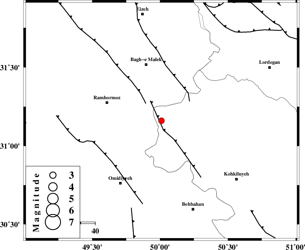
| Location | Lat:31.16 Lon: 50.01 |
| Region | 40 km South-East of Ramhormoz, Khoozestan Province |
Nearest Cities |
|
| 22 km South East of Dalan, Khoozestan Province | |
| 23 km South of Seidun, Khoozestan Province | |
| 30 km South West of Esfandan, Kohkiluieh va boyerahmad Province | |
| 32 km North East of Soltanabad, Khoozestan Province | |
| 35 km North East of Jayzan, Khoozestan Province | |
| Depth | 17 km |
| Agency | |
Faults within 150 km: |
|
| MFF4 (Length: 62 km) , Distance to epicenter: 7 km | |
| DEZFUL_EMBAYMENT (Length: 228 km) , Distance to epicenter: 16 km | |
| MFF2 (Length: 205 km) , Distance to epicenter: 24 km | |
| Number of Phases | 4 |
| RMS | 0 |
| Number of Stations | 3 |
| Error in Latitude | >6.5 km |
| Error in Longitude | 2.8 km |
| Error in Depth | 0 km |
Download waveform in seisan format
to download seisan software Click here
to access information about IIEES stations Click here
Amplitude | ||||||||
| UID | Agency | Station | Component | Amplitude | Period | Arrival Time | Proccessing Time | Signal Clip |
| 51717 | IIEES | SHGR | E | 118.1 | 0.11 | 2009-01-16 15:54:04 | 2009-06-27 08:52:00 | n |
| 51718 | IIEES | SHGR | N | 216 | 0.11 | 2009-01-16 15:54:05 | 2009-06-27 08:52:00 | n |
| 51719 | IIEES | ASAO | N | 14.3 | 0.94 | 2009-01-16 15:55:22 | 2009-06-27 08:52:00 | n |
Phase | ||||||||||||
| Agency | Station | Component | Phase Type | Phase Quality | First Motion | Observed Arrival Time | Time Residual | Loc. Flag | Input Weight | Distance | Azimuth | |
| IIEES | SHGR | Z | Pg | E | 2009-01-16 15:53:44 | 0 | y | 156 | 313 | |||
| IIEES | SHGR | N | Sg | E | 2009-01-16 15:54:03 | 0 | y | 156 | 313 | |||
| IIEES | NASN | Z | Pn | E | 2009-01-16 15:54:06 | 0 | y | 321 | 55 | |||
| IIEES | ASAO | Z | Pn | E | 2009-01-16 15:54:12 | 0 | y | 376 | 0 | |||