
Magnitude |
:3.2 |
| Date & Time (UTC) | 2009-01-13 03:45:01.6 |
| Date & Time (Local) | 1387/10/24 07:15:01.6 |
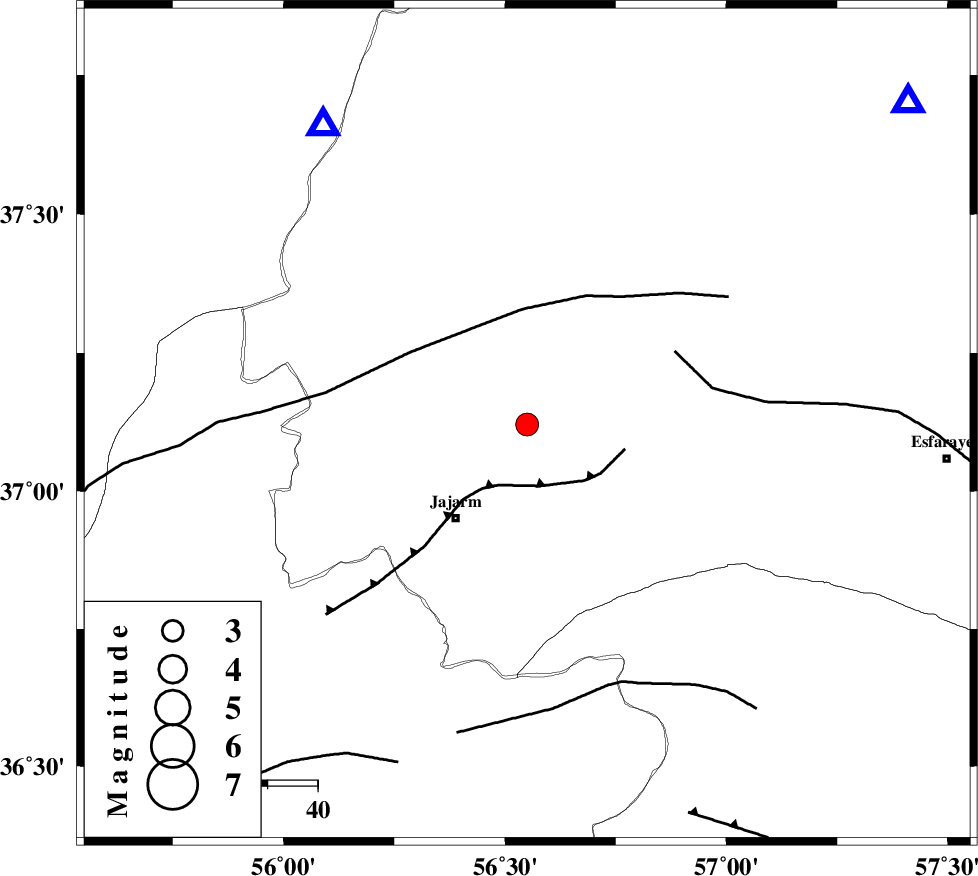
| Location | Lat:37.12 Lon: 56.55 |
| Region | 23 km North-East of Jajarm, Khorasan(north) Province |
Nearest Cities |
|
| 24 km North East of Jajarm, Khorasan(north) Province | |
| 27 km North East of Garmeh, Khorasan(north) Province | |
| 36 km South West of Shogan, Khorasan(north) Province | |
| 43 km North West of Farashiyan, Khorasan(center) Province | |
| 57 km North West of Cheharborj, Khorasan(north) Province | |
| Depth | 18 km |
| Agency | |
Faults within 150 km: |
|
| JAJARAM_F (Length: 77 km) , Distance to epicenter: 13 km | |
| ROBATE_QARABIL_F (Length: 168 km) , Distance to epicenter: 23 km | |
| ESFARAYEN_F (Length: 111 km) , Distance to epicenter: 33 km | |
| Number of Phases | 5 |
| RMS | 0.3 |
| Number of Stations | 4 |
| Error in Latitude | >6.4 km |
| Error in Longitude | 4.4 km |
| Error in Depth | 8.4 km |
Download waveform in seisan format
to download seisan software Click here
to access information about IIEES stations Click here
Amplitude | ||||||||
| UID | Agency | Station | Component | Amplitude | Period | Arrival Time | Proccessing Time | Signal Clip |
| 51696 | IIEES | BJRD | E | 551.1 | 0.16 | 2009-01-13 03:45:30 | 2009-06-27 08:52:00 | n |
| 51697 | IIEES | DAMV | N | 51 | 0.64 | 2009-01-13 03:47:24 | 2009-06-27 08:52:00 | n |
Phase | ||||||||||||
| Agency | Station | Component | Phase Type | Phase Quality | First Motion | Observed Arrival Time | Time Residual | Loc. Flag | Input Weight | Distance | Azimuth | |
| IIEES | BJRD | Z | Pg | E | 2009-01-13 03:45:18 | 0.1 | y | 99.8 | 50 | |||
| IIEES | TABS | Z | Pn | E | 2009-01-13 03:45:57 | 0 | y | 389 | 172 | |||
| IIEES | DAMV | Z | Pn | E | 2009-01-13 03:46:04 | 0 | y | 442 | 249 | |||
| IIEES | DAMV | N | Sg | E | 2009-01-13 03:47:05 | 0.3 | y | 442 | 249 | |||
| IIEES | ZNJK | Z | Pn | E | 2009-01-13 03:46:35 | -0.6 | y | 702 | 268 | |||