
Magnitude |
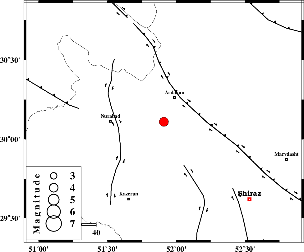
:4.2 |
| Date & Time (UTC) | 2008-11-26 07:02:28.3 |
| Date & Time (Local) | 1387/9/6 10:32:28.3 |
| Location | Lat:30.11 Lon: 51.91 |
| Region | 18 km South of Ardakan, Fars Province |
Nearest Cities |
|
| 16 km South West of Bahrghan, Fars Province | |
| 18 km South of Ardakan, Fars Province | |
| 36 km North East of Gachgaran, Fars Province | |
| 37 km East of Nurabad, Fars Province | |
| 37 km South of Kamhar, Fars Province | |
| Depth | 15 km |
| Agency | |
Faults within 150 km: |
|
| HZF3 (Length: 197 km) , Distance to epicenter: 20 km | |
| KAZERUN_F (Length: 96 km) , Distance to epicenter: 32 km | |
| KAREBASS_F (Length: 98 km) , Distance to epicenter: 34 km | |
| Number of Phases | 7 |
| RMS | 0.3 |
| Number of Stations | 7 |
| Error in Latitude | >8.3 km |
| Error in Longitude | 2.8 km |
| Error in Depth | 0 km |
Download waveform in seisan format
to download seisan software Click here
to access information about IIEES stations Click here
Amplitude | ||||||||
| UID | Agency | Station | Component | Amplitude | Period | Arrival Time | Proccessing Time | Signal Clip |
| 51247 | IIEES | SHGR | N | 903.1 | 0.62 | 2008-11-26 07:04:32 | 2009-05-17 10:07:00 | n |
| 51248 | IIEES | KRBR | N | 193.5 | 0.63 | 2008-11-26 07:04:58 | 2009-05-17 10:07:00 | n |
Phase | ||||||||||||
| Agency | Station | Component | Phase Type | Phase Quality | First Motion | Observed Arrival Time | Time Residual | Loc. Flag | Input Weight | Distance | Azimuth | |
| IIEES | NASN | Z | Pn | E | 2008-11-26 07:03:14 | 0 | y | 311 | 16 | |||
| IIEES | SHGR | Z | Pn | E | 2008-11-26 07:03:22 | 0.1 | y | 370 | 308 | |||
| IIEES | KRBR | Z | Pn | E | 2008-11-26 07:03:34 | -0.2 | y | 468 | 90 | |||
| IIEES | ASAO | Z | Pn | E | 2008-11-26 07:03:41 | 0.2 | y | 524 | 341 | |||
| IIEES | DAMV | Z | Pn | E | 2008-11-26 07:03:51 | -0.7 | y | 613 | 1 | |||
| IIEES | TABS | Z | Pn | E | 2008-11-26 07:03:54 | 0.5 | y | 630 | 50 | |||
| IIEES | CHTH | Z | Pn | E | 2008-11-26 07:03:56 | 0.1 | y | 648 | 354 | |||