
Magnitude |
:3.1 |
| Date & Time (UTC) | 2008-11-02 19:32:10.8 |
| Date & Time (Local) | 1387/8/12 23:02:10.8 |
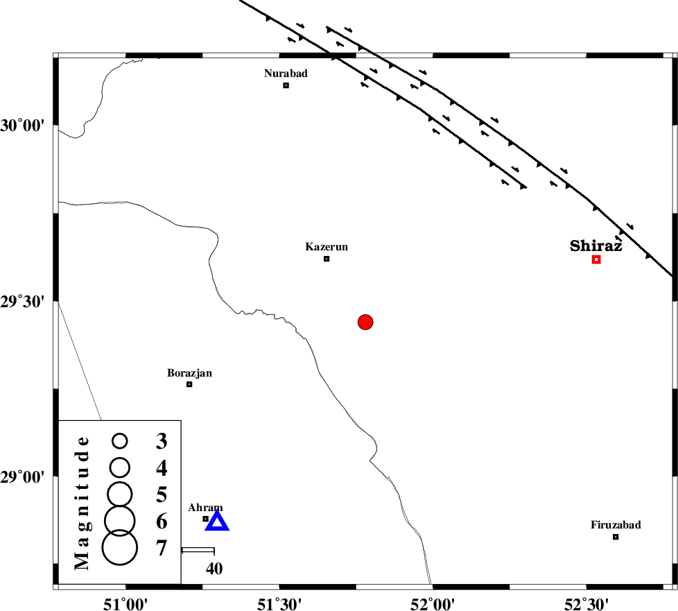
| Location | Lat:29.44 Lon: 51.78 |
| Region | 23 km South-East of Kazerun, Fars Province |
Nearest Cities |
|
| 16 km North of Dadin-e olia, Fars Province | |
| 17 km South East of Mehranjan, Fars Province | |
| 19 km South of Kalani, Fars Province | |
| 24 km North West of Baladeh, Fars Province | |
| 24 km South East of Kazerun, Fars Province | |
| Depth | 13 km |
| Agency | |
Faults within 150 km: |
|
| KAZERUN_F (Length: 96 km) , Distance to epicenter: 30 km | |
| KAREBASS_F (Length: 98 km) , Distance to epicenter: 36 km | |
| BORAZJAN_F (Length: 168 km) , Distance to epicenter: 47 km | |
| Number of Phases | 7 |
| RMS | 0.2 |
| Number of Stations | 6 |
| Error in Latitude | >5.7 km |
| Error in Longitude | 7.2 km |
| Error in Depth | 12.5 km |
Download waveform in seisan format
to download seisan software Click here
to access information about IIEES stations Click here
Amplitude | ||||||||
| UID | Agency | Station | Component | Amplitude | Period | Arrival Time | Proccessing Time | Signal Clip |
| 51090 | IIEES | BNDS | E | 16.7 | 0.58 | 2008-11-02 19:34:12 | 2009-05-17 10:07:00 | n |
| 51091 | IIEES | ASAO | N | 9.5 | 0.48 | 2008-11-02 19:34:38 | 2009-05-17 10:07:00 | n |
Phase | ||||||||||||
| Agency | Station | Component | Phase Type | Phase Quality | First Motion | Observed Arrival Time | Time Residual | Loc. Flag | Input Weight | Distance | Azimuth | |
| IIEES | NASN | Z | Pn | E | 2008-11-02 19:33:06 | 0 | y | 385 | 14 | |||
| IIEES | NASN | N | Sn | 2008-11-02 19:33:47 | 0 | y | 385 | 14 | ||||
| IIEES | BNDS | Z | Pn | E | 2008-11-02 19:33:19 | -0.1 | y | 486 | 117 | |||
| IIEES | GHVR | Z | Pn | E | 2008-11-02 19:33:28 | -0.2 | y | 561 | 355 | |||
| IIEES | ASAO | Z | Pn | E | 2008-11-02 19:33:31 | -0.2 | y | 590 | 344 | |||
| IIEES | TABS | Z | Pn | E | 2008-11-02 19:33:44 | 0.3 | y | 688 | 46 | |||
| IIEES | SNGE | Z | Pn | E | 2008-11-02 19:33:52 | 0.4 | y | 753 | 327 | |||