
Magnitude |
:3.7 |
| Date & Time (UTC) | 2008-10-23 12:00:22.1 |
| Date & Time (Local) | 1387/8/2 15:30:22.1 |
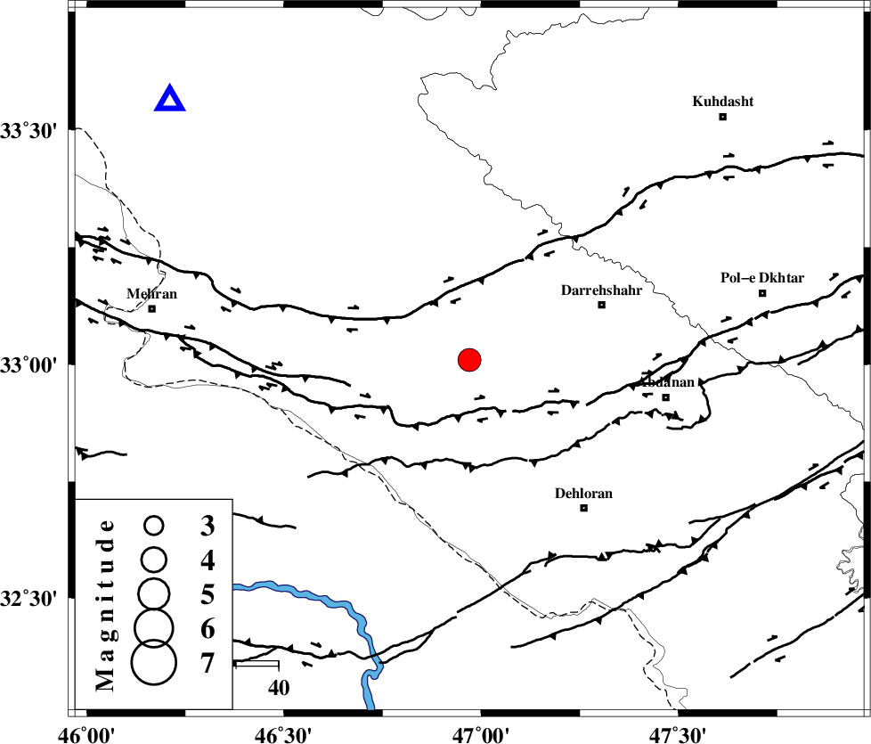
| Location | Lat:33.01 Lon: 46.97 |
| Region | 34 km South-West of Darreh Shahr, Ilam Province |
Nearest Cities |
|
| 21 km North of Bishehzar, Ilam Province | |
| 25 km South of Meymeh, Ilam Province | |
| 29 km South of Badreh, Ilam Province | |
| 34 km South West of Darreh Shahr, Ilam Province | |
| 38 km South West of Dashtabad-e olia, Ilam Province | |
| Depth | 14 km |
| Agency | |
Faults within 150 km: |
|
| MFF6 (Length: 144 km) , Distance to epicenter: 18 km | |
| BALARUD_F_Z1 (Length: 87 km) , Distance to epicenter: 32 km | |
| MFF7 (Length: 99 km) , Distance to epicenter: 48 km | |
| Number of Phases | 6 |
| RMS | 0.4 |
| Number of Stations | 4 |
| Error in Latitude | >9.4 km |
| Error in Longitude | 21.6 km |
| Error in Depth | 13 km |
Download waveform in seisan format
to download seisan software Click here
to access information about IIEES stations Click here
Amplitude | ||||||||
| UID | Agency | Station | Component | Amplitude | Period | Arrival Time | Proccessing Time | Signal Clip |
| 50887 | IIEES | SHGR | E | 613.6 | 0.36 | 2008-10-23 12:01:24 | 2009-05-17 10:07:00 | n |
| 50888 | IIEES | SHGR | N | 707 | 0.64 | 2008-10-23 12:01:38 | 2009-05-17 10:07:00 | n |
| 50889 | IIEES | SNGE | E | 414.8 | 0.58 | 2008-10-23 12:01:34 | 2009-05-17 10:07:00 | n |
| 50890 | IIEES | GHVR | N | 117.1 | 0.35 | 2008-10-23 12:02:15 | 2009-05-17 10:07:00 | n |
| 50891 | IIEES | THKV | N | 66.2 | 0.64 | 2008-10-23 12:02:24 | 2009-05-17 10:07:00 | n |
| 50892 | IIEES | THKV | E | 97.6 | 0.48 | 2008-10-23 12:02:24 | 2009-05-17 10:07:00 | n |
Phase | ||||||||||||
| Agency | Station | Component | Phase Type | Phase Quality | First Motion | Observed Arrival Time | Time Residual | Loc. Flag | Input Weight | Distance | Azimuth | |
| IIEES | SHGR | Z | Pg | E | 2008-10-23 12:00:55 | 0.3 | y | 199 | 120 | |||
| IIEES | SHGR | E | Sg | E | 2008-10-23 12:01:18 | -0.4 | y | 199 | 120 | |||
| IIEES | SNGE | Z | Pg | E | 2008-10-23 12:00:59 | -0.5 | y | 234 | 9 | |||
| IIEES | SNGE | E | Sg | E | 2008-10-23 12:01:28 | 0.1 | y | 234 | 9 | |||
| IIEES | GHVR | Z | Pn | E | 2008-10-23 12:01:23 | 0.6 | y | 429 | 66 | |||
| IIEES | THKV | Z | Pn | E | 2008-10-23 12:01:30 | 0.2 | y | 483 | 47 | |||