
Magnitude |
:3.6 |
| Date & Time (UTC) | 2008-10-21 02:03:38.1 |
| Date & Time (Local) | 1387/7/30 05:33:38.1 |
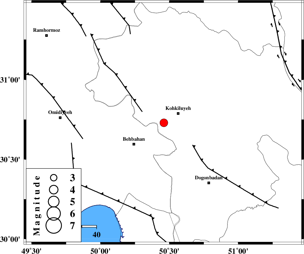
| Location | Lat:30.73 Lon: 50.46 |
| Region | 12 km West of Dehdasht, Kohkiluieh va boyerahmad Province |
Nearest Cities |
|
| 12 km West of Dehdasht, Kohkiluieh va boyerahmad Province | |
| 19 km North East of Mansuriyeh, Khoozestan Province | |
| 26 km North East of Behbahan, Khoozestan Province | |
| 27 km North East of Dodange-ye bozorg, Khoozestan Province | |
| 28 km South of Lendeh, Kohkiluieh va boyerahmad Province | |
| Depth | 17 km |
| Agency | |
Faults within 150 km: |
|
| MFF4 (Length: 62 km) , Distance to epicenter: 17 km | |
| MISHAN_F (Length: 76 km) , Distance to epicenter: 25 km | |
| AGHAJARI_F (Length: 88 km) , Distance to epicenter: 57 km | |
| Number of Phases | 5 |
| RMS | 0 |
| Number of Stations | 4 |
| Error in Latitude | >12.1 km |
| Error in Longitude | 2.8 km |
| Error in Depth | 12.6 km |
Download waveform in seisan format
to download seisan software Click here
to access information about IIEES stations Click here
Amplitude | ||||||||
| UID | Agency | Station | Component | Amplitude | Period | Arrival Time | Proccessing Time | Signal Clip |
| 50835 | IIEES | SHGR | N | 729 | 0.25 | 2008-10-21 02:05:11 | 2009-05-17 10:07:00 | n |
| 50836 | IIEES | SHGR | E | 655.2 | 0.63 | 2008-10-21 02:05:13 | 2009-05-17 10:07:00 | n |
| 50837 | IIEES | NASN | N | 82.5 | 0.58 | 2008-10-21 02:05:16 | 2009-05-17 10:07:00 | n |
Phase | ||||||||||||
| Agency | Station | Component | Phase Type | Phase Quality | First Motion | Observed Arrival Time | Time Residual | Loc. Flag | Input Weight | Distance | Azimuth | |
| IIEES | SHGR | Z | Pn | E | 2008-10-21 02:04:12 | 0 | y | 219 | 315 | |||
| IIEES | NASN | Z | Pn | E | 2008-10-21 02:04:25 | 0 | y | 320 | 44 | |||
| IIEES | NASN | E | Sg | E | 2008-10-21 02:05:08 | 0 | y | 320 | 44 | |||
| IIEES | GHVR | Z | Pn | E | 2008-10-21 02:04:38 | 0 | y | 423 | 10 | |||
| IIEES | SNGE | Z | Pn | E | 2008-10-21 02:04:55 | 0 | y | 565 | 330 | |||