
Magnitude |
:2.9 |
| Date & Time (UTC) | 2008-10-12 18:11:38.0 |
| Date & Time (Local) | 1387/7/21 21:41:38.0 |
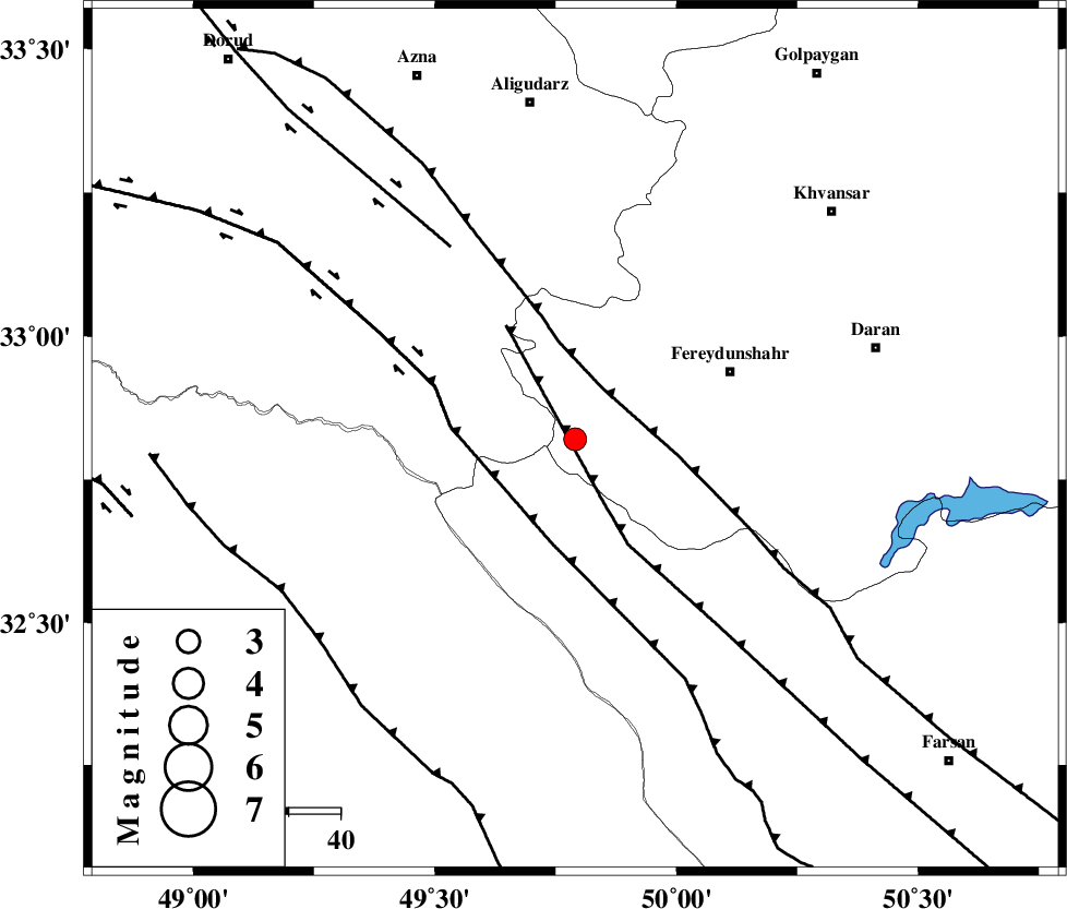
| Location | Lat:32.82 Lon: 49.79 |
| Region | 33 km South-West of Fereydunshahr, Esfahan Province |
Nearest Cities |
|
| 7 km of Masir, Esfahan Province | |
| 16 km North of Durak, Chaharmahal Bakhtiari Province | |
| 26 km West of Sibak, Esfahan Province | |
| 30 km South of Farsesh, Lorestan Province | |
| 31 km East of Parchal, Lorestan Province | |
| Depth | 15 km |
| Agency | |
Faults within 150 km: |
|
| MAIN_ZAGROS_R_F (Length: 1106 km) , Distance to epicenter: 11 km | |
| ARDAL_F (Length: 170 km) , Distance to epicenter: 13 km | |
| ZARDKUH_F (Length: 139 km) , Distance to epicenter: 21 km | |
| Number of Phases | 7 |
| RMS | 0.1 |
| Number of Stations | 6 |
| Error in Latitude | >1.8 km |
| Error in Longitude | 2.1 km |
| Error in Depth | 2.9 km |
Download waveform in seisan format
to download seisan software Click here
to access information about IIEES stations Click here
Amplitude | ||||||||
| UID | Agency | Station | Component | Amplitude | Period | Arrival Time | Proccessing Time | Signal Clip |
| 50765 | IIEES | SHGR | N | 500.8 | 0.6 | 2008-10-12 18:12:19 | 2009-05-17 10:07:00 | n |
| 50766 | IIEES | SHGR | E | 248.2 | 0.6 | 2008-10-12 18:12:21 | 2009-05-17 10:07:00 | n |
| 50767 | IIEES | GHVR | E | 70.4 | 0.76 | 2008-10-12 18:12:46 | 2009-05-17 10:07:00 | n |
| 50768 | IIEES | GHVR | N | 74.6 | 0.48 | 2008-10-12 18:12:46 | 2009-05-17 10:07:00 | n |
Phase | ||||||||||||
| Agency | Station | Component | Phase Type | Phase Quality | First Motion | Observed Arrival Time | Time Residual | Loc. Flag | Input Weight | Distance | Azimuth | |
| IIEES | SHGR | Z | Pg | E | 2008-10-12 18:11:58 | 0 | y | 122 | 230 | |||
| IIEES | GHVR | Z | Pn | E | 2008-10-12 18:12:14 | 0 | y | 229 | 36 | |||
| IIEES | GHVR | N | Sg | E | 2008-10-12 18:12:42 | 0 | y | 229 | 36 | |||
| IIEES | NASN | Z | Pn | E | 2008-10-12 18:12:21 | -0.1 | y | 283 | 90 | |||
| IIEES | SNGE | Z | Pn | E | 2008-10-12 18:12:27 | -0.1 | y | 338 | 319 | |||
| IIEES | CHTH | Z | Pn | E | 2008-10-12 18:12:31 | 0.1 | y | 364 | 19 | |||
| IIEES | DAMV | Z | Pn | E | 2008-10-12 18:12:31 | 0 | y | 371 | 32 | |||