
Magnitude |
:2.5 |
| Date & Time (UTC) | 2008-10-05 01:37:36.8 |
| Date & Time (Local) | 1387/7/14 05:07:36.8 |
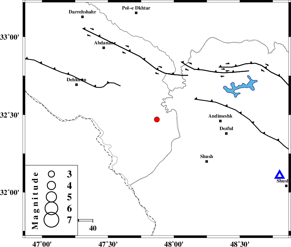
| Location | Lat:32.47 Lon: 47.87 |
| Region | 45 km West of Andimeshk, Khoozestan Province |
Nearest Cities |
|
| 42 km South West of Hoseinieh, Khoozestan Province | |
| 45 km North West of Andimeshk, Khoozestan Province | |
| 47 km North West of Shush, Khoozestan Province | |
| 47 km South West of Bidruyeh, Khoozestan Province | |
| 49 km East of Musian, Ilam Province | |
| Depth | 14 km |
| Agency | |
Faults within 150 km: |
|
| DEZFUL_EMBAYMENT (Length: 228 km) , Distance to epicenter: 30 km | |
| BALARUD_F_Z1 (Length: 87 km) , Distance to epicenter: 33 km | |
| MFF6 (Length: 144 km) , Distance to epicenter: 35 km | |
| Number of Phases | 5 |
| RMS | 0.1 |
| Number of Stations | 3 |
| Error in Latitude | >4.7 km |
| Error in Longitude | 5.8 km |
| Error in Depth | 8.6 km |
Download waveform in seisan format
to download seisan software Click here
to access information about IIEES stations Click here
Amplitude | ||||||||
| UID | Agency | Station | Component | Amplitude | Period | Arrival Time | Proccessing Time | Signal Clip |
| 50694 | IIEES | SNGE | E | 20.3 | 0.52 | 2008-10-05 01:39:04 | 2009-05-17 10:07:00 | n |
| 50695 | IIEES | ASAO | E | 17.1 | 0.48 | 2008-10-05 01:39:03 | 2009-05-17 10:07:00 | n |
| 50696 | IIEES | GHVR | E | 11.8 | 0.4 | 2008-10-05 01:39:17 | 2009-05-17 10:07:00 | n |
Phase | ||||||||||||
| Agency | Station | Component | Phase Type | Phase Quality | First Motion | Observed Arrival Time | Time Residual | Loc. Flag | Input Weight | Distance | Azimuth | |
| IIEES | SNGE | Z | P | E | 2008-10-05 01:38:21 | 0.1 | y | 295 | 351 | |||
| IIEES | SNGE | E | Sg | E | 2008-10-05 01:38:59 | 0 | y | 295 | 351 | |||
| IIEES | ASAO | Z | Pn | E | 2008-10-05 01:38:22 | -0.2 | y | 305 | 40 | |||
| IIEES | GHVR | Z | Pn | E | 2008-10-05 01:38:32 | 0.1 | y | 385 | 54 | |||
| IIEES | GHVR | E | Sn | 2008-10-05 01:39:12 | 0 | y | 385 | 54 | ||||