
Magnitude |
:3.8 |
| Date & Time (UTC) | 2008-09-20 12:35:13.1 |
| Date & Time (Local) | 1387/6/30 17:05:13.1 |
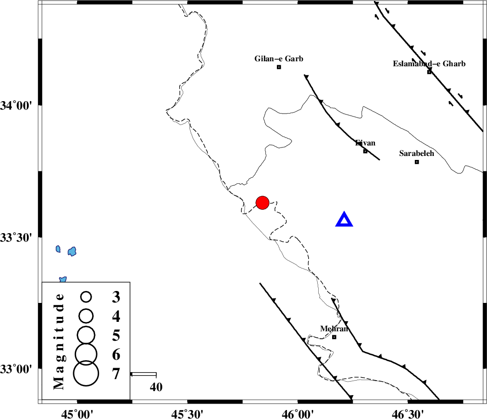
| Location | Lat:33.63 Lon: 45.84 |
| Region | 48 km South-West of Eyvan, Ilam Province |
Nearest Cities |
|
| 33 km South East of Sumar, Kermanshah Province | |
| 37 km North West of Salehabad, Ilam Province | |
| 40 km West of Chavar, Ilam Province | |
| 45 km South West of Teran, Ilam Province | |
| 46 km South West of Zarneh, Ilam Province | |
| Depth | 18 km |
| Agency | |
Faults within 150 km: |
|
| MFF7 (Length: 99 km) , Distance to epicenter: 11 km | |
| ZFF4 (Length: 128 km) , Distance to epicenter: 13 km | |
| MFF6 (Length: 144 km) , Distance to epicenter: 64 km | |
| Number of Phases | 6 |
| RMS | 0.1 |
| Number of Stations | 5 |
| Error in Latitude | >4.9 km |
| Error in Longitude | 3.6 km |
| Error in Depth | 0 km |
Download waveform in seisan format
to download seisan software Click here
to access information about IIEES stations Click here
Amplitude | ||||||||
| UID | Agency | Station | Component | Amplitude | Period | Arrival Time | Proccessing Time | Signal Clip |
| 50496 | IIEES | SNGE | E | 1027.3 | 0.8 | 2008-09-20 12:36:19 | 2009-05-05 01:27:00 | n |
| 50497 | IIEES | ASAO | N | 102.4 | 1.17 | 2008-09-20 12:37:12 | 2009-05-05 01:27:00 | n |
| 50498 | IIEES | GHVR | N | 93.5 | 1.14 | 2008-09-20 12:37:20 | 2009-05-05 01:27:00 | n |
| 50499 | IIEES | GHVR | E | 78.8 | 0.68 | 2008-09-20 12:37:42 | 2009-05-05 01:27:00 | n |
Phase | ||||||||||||
| Agency | Station | Component | Phase Type | Phase Quality | First Motion | Observed Arrival Time | Time Residual | Loc. Flag | Input Weight | Distance | Azimuth | |
| IIEES | SNGE | Z | Pg | E | 2008-09-20 12:35:48 | 0 | y | 213 | 40 | |||
| IIEES | ASAO | Z | Pn | E | 2008-09-20 12:36:10 | 0 | y | 399 | 74 | |||
| IIEES | GHVR | Z | Pn | E | 2008-09-20 12:36:23 | 0 | y | 508 | 78 | |||
| IIEES | GHVR | E | Sg | E | 2008-09-20 12:37:34 | 0 | y | 508 | 78 | |||
| IIEES | CHTH | Z | Pn | E | 2008-09-20 12:36:28 | -0.2 | y | 546 | 61 | |||
| IIEES | DAMV | Z | Pn | E | 2008-09-20 12:36:35 | 0.2 | y | 604 | 67 | |||