
Magnitude |
:3 |
| Date & Time (UTC) | 2008-09-17 07:23:33.1 |
| Date & Time (Local) | 1387/6/27 11:53:33.1 |
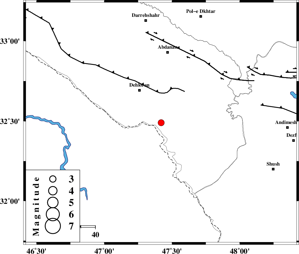
| Location | Lat:32.49 Lon: 47.42 |
| Region | 27 km South-East of Dehloran, Ilam Province |
Nearest Cities |
|
| 8 km of Musian, Ilam Province | |
| 27 km South East of Dehloran, Ilam Province | |
| 47 km South West of Sarabbagh, Ilam Province | |
| 49 km South of Abdanan, Ilam Province | |
| 56 km South East of Bishehzar, Ilam Province | |
| Depth | 14 km |
| Agency | |
Faults within 150 km: |
|
| MFF6 (Length: 144 km) , Distance to epicenter: 21 km | |
| BALARUD_F_Z1 (Length: 87 km) , Distance to epicenter: 52 km | |
| DEZFUL_EMBAYMENT (Length: 228 km) , Distance to epicenter: 70 km | |
| Number of Phases | 5 |
| RMS | 0.1 |
| Number of Stations | 4 |
| Error in Latitude | >2.5 km |
| Error in Longitude | 6 km |
| Error in Depth | 7.2 km |
Download waveform in seisan format
to download seisan software Click here
to access information about IIEES stations Click here
Amplitude | ||||||||
| UID | Agency | Station | Component | Amplitude | Period | Arrival Time | Proccessing Time | Signal Clip |
| 50408 | IIEES | ASAO | N | 37.4 | 0.62 | 2008-09-17 07:25:15 | 2009-05-05 01:27:00 | n |
| 50409 | IIEES | GHVR | E | 31 | 0.61 | 2008-09-17 07:25:41 | 2009-05-05 01:27:00 | n |
| 50410 | IIEES | GHVR | N | 30.1 | 0.7 | 2008-09-17 07:25:47 | 2009-05-05 01:27:00 | n |
Phase | ||||||||||||
| Agency | Station | Component | Phase Type | Phase Quality | First Motion | Observed Arrival Time | Time Residual | Loc. Flag | Input Weight | Distance | Azimuth | |
| IIEES | SHGR | Z | Pg | E | 2008-09-17 07:23:55 | -0.1 | y | 137 | 108 | |||
| IIEES | SNGE | Z | Pn | E | 2008-09-17 07:24:16 | 0 | y | 289 | 359 | |||
| IIEES | ASAO | Z | Pn | E | 2008-09-17 07:24:22 | -0.1 | y | 333 | 46 | |||
| IIEES | ASAO | E | Sg | E | 2008-09-17 07:25:06 | 0 | y | 333 | 46 | |||
| IIEES | GHVR | Z | Pn | E | 2008-09-17 07:24:32 | 0.2 | y | 418 | 57 | |||