
Magnitude |
:2.7 |
| Date & Time (UTC) | 2008-09-13 02:00:58.5 |
| Date & Time (Local) | 1387/6/23 06:30:58.5 |
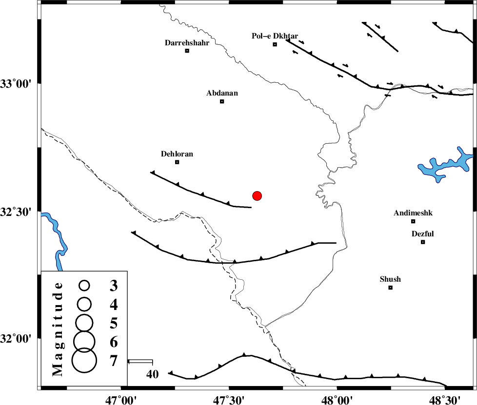
| Location | Lat:32.56 Lon: 47.63 |
| Region | 37 km South-East of Dehloran, Ilam Province |
Nearest Cities |
|
| 25 km North East of Musian, Ilam Province | |
| 38 km South East of Dehloran, Ilam Province | |
| 38 km South of Sarabbagh, Ilam Province | |
| 44 km South East of Abdanan, Ilam Province | |
| 59 km South West of Hoseinieh, Khoozestan Province | |
| Depth | 14 km |
| Agency | |
Faults within 150 km: |
|
| MFF6 (Length: 144 km) , Distance to epicenter: 14 km | |
| BALARUD_F_Z1 (Length: 87 km) , Distance to epicenter: 34 km | |
| DEZFUL_EMBAYMENT (Length: 228 km) , Distance to epicenter: 49 km | |
| Number of Phases | 5 |
| RMS | 0.2 |
| Number of Stations | 4 |
| Error in Latitude | >3.1 km |
| Error in Longitude | 5.3 km |
| Error in Depth | 7.3 km |
Download waveform in seisan format
to download seisan software Click here
to access information about IIEES stations Click here
Amplitude | ||||||||
| UID | Agency | Station | Component | Amplitude | Period | Arrival Time | Proccessing Time | Signal Clip |
| 50338 | IIEES | SHGR | E | 356.8 | 0.32 | 2008-09-13 02:01:39 | 2009-05-05 01:27:00 | n |
| 50339 | IIEES | SHGR | N | 438.1 | 0.4 | 2008-09-13 02:01:39 | 2009-05-05 01:27:00 | n |
| 50340 | IIEES | SNGE | E | 20.8 | 0.44 | 2008-09-13 02:02:29 | 2009-05-05 01:27:00 | n |
| 50341 | IIEES | ASAO | N | 14.5 | 0.48 | 2008-09-13 02:02:32 | 2009-05-05 01:27:00 | n |
| 50342 | IIEES | ASAO | E | 18.3 | 0.52 | 2008-09-13 02:02:41 | 2009-05-05 01:27:00 | n |
Phase | ||||||||||||
| Agency | Station | Component | Phase Type | Phase Quality | First Motion | Observed Arrival Time | Time Residual | Loc. Flag | Input Weight | Distance | Azimuth | |
| IIEES | SHGR | Z | Pg | E | 2008-09-13 02:01:18 | -0.2 | y | 121 | 114 | |||
| IIEES | SNGE | Z | Pn | E | 2008-09-13 02:01:41 | 0 | y | 282 | 355 | |||
| IIEES | SNGE | E | Sg | E | 2008-09-13 02:02:17 | -0.1 | y | 282 | 355 | |||
| IIEES | ASAO | N | Sg | E | 2008-09-13 02:02:26 | 0 | y | 313 | 45 | |||
| IIEES | GHVR | Z | Pn | E | 2008-09-13 02:01:55 | 0.3 | y | 398 | 57 | |||