
Magnitude |
:3.6 |
| Date & Time (UTC) | 2008-09-10 16:25:35.5 |
| Date & Time (Local) | 1387/6/20 20:55:35.5 |
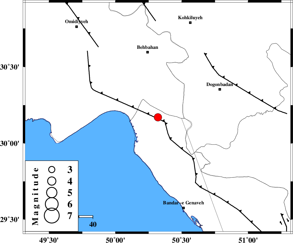
| Location | Lat:30.17 Lon: 50.32 |
| Region | 47 km South of Behbahan, Khoozestan Province |
Nearest Cities |
|
| 12 km North of Siyahmakan-e bozorg, Bushehr Province | |
| 13 km North East of Ameri, Bushehr Province | |
| 19 km South of Sardasht, Khoozestan Province | |
| 33 km South East of Darunak, Khoozestan Province | |
| 37 km North of Emamhasan, Bushehr Province | |
| Depth | 15 km |
| Agency | |
Faults within 150 km: |
|
| RAG_E_SEFID_F (Length: 84 km) , Distance to epicenter: 6 km | |
| ZFF3 (Length: 125 km) , Distance to epicenter: 6 km | |
| MISHAN_F (Length: 76 km) , Distance to epicenter: 54 km | |
| Number of Phases | 5 |
| RMS | 0.2 |
| Number of Stations | 5 |
| Error in Latitude | >7.8 km |
| Error in Longitude | 2.3 km |
| Error in Depth | 0 km |
Download waveform in seisan format
to download seisan software Click here
to access information about IIEES stations Click here
Amplitude | ||||||||
| UID | Agency | Station | Component | Amplitude | Period | Arrival Time | Proccessing Time | Signal Clip |
| 50292 | IIEES | ASAO | E | 56.3 | 0.64 | 2008-09-10 16:28:08 | 2009-05-05 01:27:00 | n |
| 50293 | IIEES | GHVR | N | 55.9 | 0.72 | 2008-09-10 16:28:07 | 2009-05-05 01:27:00 | n |
Phase | ||||||||||||
| Agency | Station | Component | Phase Type | Phase Quality | First Motion | Observed Arrival Time | Time Residual | Loc. Flag | Input Weight | Distance | Azimuth | |
| IIEES | NASN | Z | Pn | E | 2008-09-10 16:26:29 | -0.2 | y | 375 | 38 | |||
| IIEES | GHVR | Z | Pn | E | 2008-09-10 16:26:43 | 0.2 | y | 486 | 10 | |||
| IIEES | ASAO | Z | Pn | E | 2008-09-10 16:26:43 | 0.1 | y | 486 | 357 | |||
| IIEES | SNGE | Z | Pn | E | 2008-09-10 16:26:59 | -0.2 | y | 613 | 334 | |||
| IIEES | KRBR | Z | Pn | E | 2008-09-10 16:27:00 | 0.1 | y | 621 | 90 | |||