
Magnitude |
:3.3 |
| Date & Time (UTC) | 2008-09-04 08:42:48.4 |
| Date & Time (Local) | 1387/6/14 13:12:48.4 |
| Location | Lat:32.58 Lon: 47.45 |
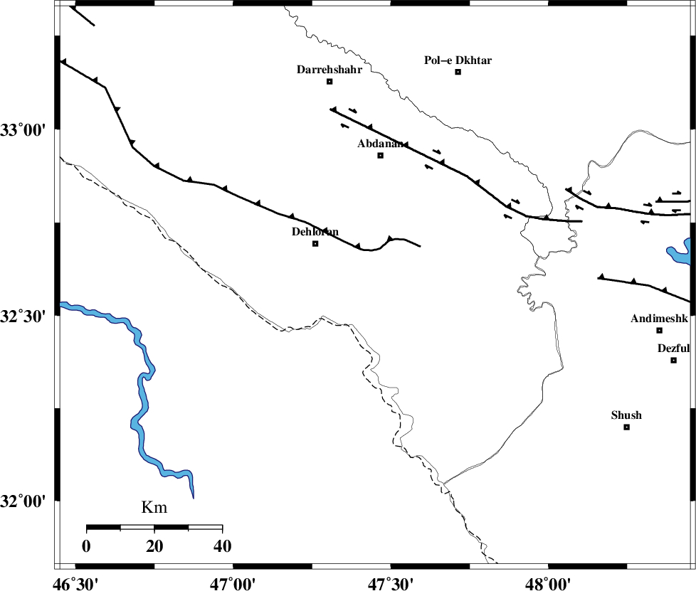
| Region | 21 km South-East of Dehloran, Ilam Province |
Nearest Cities |
|
| 9 km North of Musian, Ilam Province | |
| 22 km South East of Dehloran, Ilam Province | |
| 37 km South West of Sarabbagh, Ilam Province | |
| 39 km South of Abdanan, Ilam Province | |
| 52 km South East of Bishehzar, Ilam Province | |
| Depth | 14 km |
| Agency | |
Faults within 150 km: |
|
| MFF6 (Length: 144 km) , Distance to epicenter: 11 km | |
| BALARUD_F_Z1 (Length: 87 km) , Distance to epicenter: 43 km | |
| BALARUD_F_Z3 (Length: 53 km) , Distance to epicenter: 63 km | |
| Number of Phases | 8 |
| RMS | 0.1 |
| Number of Stations | 7 |
| Error in Latitude | >3.7 km |
| Error in Longitude | 7.4 km |
| Error in Depth | 3.7 km |
Download waveform in seisan format
to download seisan software Click here
to access information about IIEES stations Click here
Amplitude | ||||||||
| UID | Agency | Station | Component | Amplitude | Period | Arrival Time | Proccessing Time | Signal Clip |
| 50129 | IIEES | SHGR | N | 640.8 | 0.85 | 2008-09-04 08:43:33 | 2009-05-05 01:27:00 | n |
| 50130 | IIEES | SNGE | E | 176.8 | 0.69 | 2008-09-04 08:44:17 | 2009-05-05 01:27:00 | n |
| 50131 | IIEES | ASAO | E | 107.6 | 0.53 | 2008-09-04 08:44:29 | 2009-05-05 01:27:00 | n |
| 50132 | IIEES | ASAO | N | 99.8 | 0.61 | 2008-09-04 08:44:30 | 2009-05-05 01:27:00 | n |
| 50133 | IIEES | GHVR | E | 41.9 | 0.65 | 2008-09-04 08:44:36 | 2009-05-05 01:27:00 | n |
| 50134 | IIEES | GHVR | N | 37.3 | 0.68 | 2008-09-04 08:44:46 | 2009-05-05 01:27:00 | n |
Phase | ||||||||||||
| Agency | Station | Component | Phase Type | Phase Quality | First Motion | Observed Arrival Time | Time Residual | Loc. Flag | Input Weight | Distance | Azimuth | |
| IIEES | SHGR | Z | Pg | E | 2008-09-04 08:43:11 | -0.2 | y | 138 | 112 | |||
| IIEES | SNGE | Z | Pn | E | 2008-09-04 08:43:30 | 0 | y | 279 | 358 | |||
| IIEES | SNGE | E | Sg | E | 2008-09-04 08:44:07 | -0.1 | y | 279 | 358 | |||
| IIEES | ASAO | Z | Pn | E | 2008-09-04 08:43:36 | 0.2 | y | 324 | 47 | |||
| IIEES | GHVR | Z | Pn | E | 2008-09-04 08:43:47 | 0.1 | y | 411 | 58 | |||
| IIEES | ZNJK | Z | Pn | E | 2008-09-04 08:43:54 | 0 | y | 468 | 14 | |||
| IIEES | CHTH | Z | Pn | E | 2008-09-04 08:43:58 | 0 | y | 501 | 42 | |||
| IIEES | DAMV | Z | Pn | E | 2008-09-04 08:44:03 | 0.1 | y | 537 | 50 | |||