
Magnitude |
:3.2 |
| Date & Time (UTC) | 2008-05-26 06:21:22.5 |
| Date & Time (Local) | 1387/3/6 10:51:22.5 |
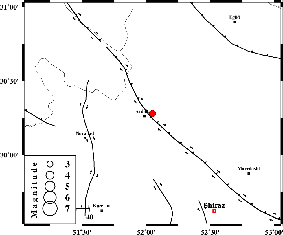
| Location | Lat:30.28 Lon: 52.05 |
| Region | 6 km Ardakan, Fars Province |
Nearest Cities |
|
| 6 km North of Ardakan, Fars Province | |
| 7 km North of Bahrghan, Fars Province | |
| 25 km South East of Kamhar, Fars Province | |
| 36 km South West of Bekan, Fars Province | |
| 37 km North West of Dorudzan, Fars Province | |
| Depth | 15 km |
| Agency | |
Faults within 150 km: |
|
| HZF3 (Length: 197 km) , Distance to epicenter: 3 km | |
| KAREBASS_F (Length: 98 km) , Distance to epicenter: 49 km | |
| KAZERUN_F (Length: 96 km) , Distance to epicenter: 51 km | |
| Number of Phases | 5 |
| RMS | 0.1 |
| Number of Stations | 5 |
| Error in Latitude | >2.4 km |
| Error in Longitude | 1.4 km |
| Error in Depth | 0 km |
Download waveform in seisan format
to download seisan software Click here
to access information about IIEES stations Click here
Amplitude | ||||||||
| UID | Agency | Station | Component | Amplitude | Period | Arrival Time | Proccessing Time | Signal Clip |
| 49211 | IIEES | GHIR | E | 200.2 | 0.6 | 2008-05-26 06:22:41 | 2009-01-18 12:56:00 | n |
| 49212 | IIEES | GHIR | N | 206.2 | 0.4 | 2008-05-26 06:22:43 | 2009-01-18 12:56:00 | n |
| 49213 | IIEES | ASAO | N | 17.6 | 0.76 | 2008-05-26 06:23:59 | 2009-01-18 12:56:00 | n |
| 49214 | IIEES | BNDS | N | 19.4 | 0.38 | 2008-05-26 06:23:34 | 2009-01-18 12:56:00 | n |
Phase | ||||||||||||
| Agency | Station | Component | Phase Type | Phase Quality | First Motion | Observed Arrival Time | Time Residual | Loc. Flag | Input Weight | Distance | Azimuth | |
| IIEES | GHIR | Z | Pn | E | 2008-05-26 06:21:59 | 0 | y | 239 | 157 | |||
| IIEES | KRBR | Z | Pn | E | 2008-05-26 06:22:26 | 0 | y | 455 | 93 | |||
| IIEES | ASAO | Z | Pn | E | 2008-05-26 06:22:33 | 0 | y | 510 | 339 | |||
| IIEES | BNDS | Z | Pn | E | 2008-05-26 06:22:33 | -0.1 | y | 513 | 127 | |||
| IIEES | SNGE | Z | Pn | E | 2008-05-26 06:22:56 | -0.1 | y | 692 | 322 | |||