
Magnitude |
:3 |
| Date & Time (UTC) | 2008-05-02 21:29:19.1 |
| Date & Time (Local) | 1387/2/14 01:59:19.1 |
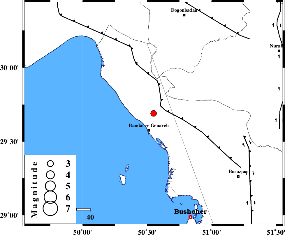
| Location | Lat:29.69 Lon: 50.55 |
| Region | 13 km North of Bandar-e genaveh, Bushehr Province |
Nearest Cities |
|
| 8 km North of Mohammad salehi, Bushehr Province | |
| 13 km North of Bandar-e genaveh, Bushehr Province | |
| 24 km North of Bandarehrig, Bushehr Province | |
| 27 km North West of Chehar rustaee, Bushehr Province | |
| 33 km South East of Emamhasan, Bushehr Province | |
| Depth | 15 km |
| Agency | |
Faults within 150 km: |
|
| ZFF3 (Length: 125 km) , Distance to epicenter: 8 km | |
| RAG_E_SEFID_F (Length: 84 km) , Distance to epicenter: 53 km | |
| BORAZJAN_F (Length: 168 km) , Distance to epicenter: 69 km | |
| Number of Phases | 5 |
| RMS | 0.4 |
| Number of Stations | 5 |
| Error in Latitude | >8.9 km |
| Error in Longitude | 4.5 km |
| Error in Depth | 0 km |
Download waveform in seisan format
to download seisan software Click here
to access information about IIEES stations Click here
Amplitude | ||||||||
| UID | Agency | Station | Component | Amplitude | Period | Arrival Time | Proccessing Time | Signal Clip |
| 49037 | IIEES | GHIR | N | 124.1 | 0.52 | 2008-05-02 21:30:51 | 2009-01-18 12:56:00 | n |
| 49038 | IIEES | GHIR | E | 100.4 | 0.64 | 2008-05-02 21:30:56 | 2009-01-18 12:56:00 | n |
| 49039 | IIEES | ASAO | N | 6.2 | 0.48 | 2008-05-02 21:31:40 | 2009-01-18 12:56:00 | n |
| 49040 | IIEES | ASAO | E | 5.2 | 0.48 | 2008-05-02 21:31:46 | 2009-01-18 12:56:00 | n |
Phase | ||||||||||||
| Agency | Station | Component | Phase Type | Phase Quality | First Motion | Observed Arrival Time | Time Residual | Loc. Flag | Input Weight | Distance | Azimuth | |
| IIEES | GHIR | Z | Pn | E | 2008-05-02 21:30:02 | 0.2 | y | 284 | 123 | |||
| IIEES | NASN | Z | Pn | E | 2008-05-02 21:30:17 | 0.3 | y | 406 | 31 | |||
| IIEES | ASAO | Z | Pn | E | 2008-05-02 21:30:34 | 0.2 | y | 541 | 355 | |||
| IIEES | KRBR | Z | Pn | E | 2008-05-02 21:30:40 | -0.6 | y | 601 | 85 | |||
| IIEES | SNGE | Z | Pn | E | 2008-05-02 21:30:49 | -0.4 | y | 671 | 334 | |||