
Magnitude |
:2.9 |
| Date & Time (UTC) | 2008-04-29 06:10:43.8 |
| Date & Time (Local) | 1387/2/10 10:40:43.8 |
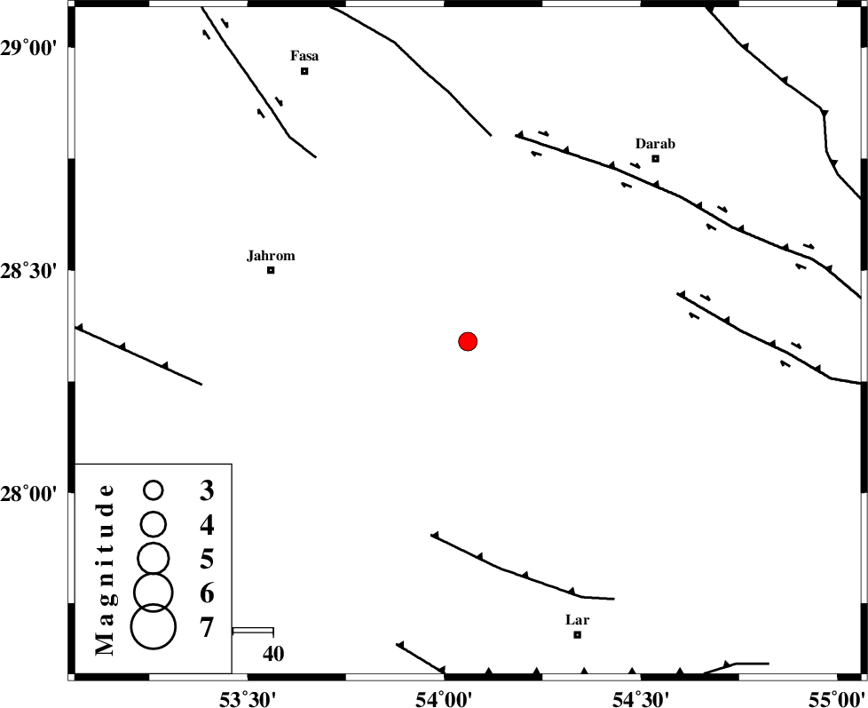
| Location | Lat:28.34 Lon: 54.06 |
| Region | 52 km South-East of Jahrom, Fars Province |
Nearest Cities |
|
| 16 km West of Dabiran, Fars Province | |
| 25 km North East of Juyam, Fars Province | |
| 28 km North West of Shahr-e pir, Fars Province | |
| 35 km West of Hajiabad, Fars Province | |
| 35 km South East of Khorramabad, Fars Province | |
| Depth | 41 km |
| Agency | |
Faults within 150 km: |
|
| BERIZ_F (Length: 49 km) , Distance to epicenter: 49 km | |
| BAKHTEGAN_F (Length: 94 km) , Distance to epicenter: 52 km | |
| HZF1 (Length: 102 km) , Distance to epicenter: 53 km | |
| Number of Phases | 5 |
| RMS | 0.4 |
| Number of Stations | 4 |
| Error in Latitude | >8 km |
| Error in Longitude | 5.8 km |
| Error in Depth | 9.8 km |
Download waveform in seisan format
to download seisan software Click here
to access information about IIEES stations Click here
Amplitude | ||||||||
| UID | Agency | Station | Component | Amplitude | Period | Arrival Time | Proccessing Time | Signal Clip |
| 49017 | IIEES | GHIR | E | 386.1 | 0.33 | 2008-04-29 06:11:24 | 2009-01-18 12:56:00 | n |
| 49018 | IIEES | GHIR | N | 303.7 | 0.44 | 2008-04-29 06:11:34 | 2009-01-18 12:56:00 | n |
| 49019 | IIEES | BNDS | N | 55.6 | 0.57 | 2008-04-29 06:12:18 | 2009-01-18 12:56:00 | n |
| 49020 | IIEES | KRBR | N | 39.8 | 0.58 | 2008-04-29 06:12:15 | 2009-01-18 12:56:00 | n |
| 49021 | IIEES | KRBR | E | 39.2 | 0.48 | 2008-04-29 06:12:25 | 2009-01-18 12:56:00 | n |
Phase | ||||||||||||
| Agency | Station | Component | Phase Type | Phase Quality | First Motion | Observed Arrival Time | Time Residual | Loc. Flag | Input Weight | Distance | Azimuth | |
| IIEES | GHIR | Z | Pg | E | 2008-04-29 06:11:02 | 0.1 | y | 105 | 267 | |||
| IIEES | BNDS | Z | Pn | E | 2008-04-29 06:11:17 | -0.2 | y | 232 | 116 | |||
| IIEES | KRBR | Z | Pn | E | 2008-04-29 06:11:29 | 0.6 | y | 320 | 55 | |||
| IIEES | KRBR | N | Sg | E | 2008-04-29 06:12:11 | -0.1 | y | 320 | 55 | |||
| IIEES | NASN | Z | PN5 | E | 2008-04-29 06:11:52 | -0.4 | y | 509 | 347 | |||