
Magnitude |
:3.7 |
| Date & Time (UTC) | 2007-12-18 01:02:21.2 |
| Date & Time (Local) | 1386/9/27 04:32:21.2 |
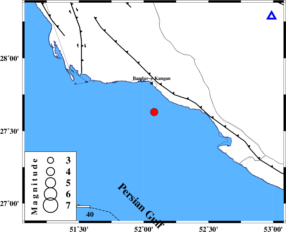
| Location | Lat:27.63 Lon: 52.08 |
| Region | Persian Gulf, 21 km South of Bandar-e kangan |
Nearest Cities |
|
| 22 km South of Bandar-e kangan, Bushehr Province | |
| 26 km West of Bandar-e taheri, Bushehr Province | |
| 32 km South West of Jam, Bushehr Province | |
| 46 km South of Riz, Bushehr Province | |
| 55 km North West of Bandar-e asaluyeh, Bushehr Province | |
| Depth | 24 km |
| Agency | |
Faults within 150 km: |
|
| MFF3 (Length: 292 km) , Distance to epicenter: 20 km | |
| BORAZJAN_F (Length: 168 km) , Distance to epicenter: 63 km | |
| MFF5 (Length: 74 km) , Distance to epicenter: 82 km | |
| Number of Phases | 8 |
| RMS | 0.2 |
| Number of Stations | 6 |
| Error in Latitude | >4.2 km |
| Error in Longitude | 3.1 km |
| Error in Depth | 3.8 km |
Download waveform in seisan format
to download seisan software Click here
to access information about IIEES stations Click here
Amplitude | ||||||||
| UID | Agency | Station | Component | Amplitude | Period | Arrival Time | Proccessing Time | Signal Clip |
| 40568 | IIEES | GHIR | E | 2775.8 | 0.64 | 2007-12-18 01:02:57 | 2008-04-12 10:47:00 | n |
| 40569 | IIEES | GHIR | N | 2021.9 | 0.44 | 2007-12-18 01:02:58 | 2008-04-12 10:47:00 | n |
| 40570 | IIEES | KRBR | E | 52.1 | 0.64 | 2007-12-18 01:04:32 | 2008-04-12 10:47:00 | n |
| 40571 | IIEES | KRBR | N | 60 | 0.64 | 2007-12-18 01:04:35 | 2008-04-12 10:47:00 | n |
Phase | ||||||||||||
| Agency | Station | Component | Phase Type | Phase Quality | First Motion | Observed Arrival Time | Time Residual | Loc. Flag | Input Weight | Distance | Azimuth | |
| IIEES | GHIR | Z | Pg | E | 2007-12-18 01:02:40 | 0.1 | y | 115 | 51 | |||
| IIEES | GHIR | N | Sg | E | 2007-12-18 01:02:54 | 0 | y | 115 | 51 | |||
| IIEES | BNDS | Z | Pn | E | 2007-12-18 01:03:18 | 0 | y | 405 | 93 | |||
| IIEES | KRBR | Z | Pn | E | 2007-12-18 01:03:33 | 0 | y | 526 | 59 | |||
| IIEES | KRBR | E | Sn | 2007-12-18 01:04:26 | 0.1 | y | 526 | 59 | ||||
| IIEES | NASN | Z | Pn | E | 2007-12-18 01:03:39 | -0.3 | y | 577 | 7 | |||
| IIEES | ASAO | Z | Pn | E | 2007-12-18 01:04:06 | 0.4 | y | 791 | 346 | |||
| IIEES | SNGE | Z | Pn | E | 2007-12-18 01:04:24 | -0.2 | y | 941 | 333 | |||