
Magnitude |
:2.7 |
| Date & Time (UTC) | 2007-10-13 00:19:18.3 |
| Date & Time (Local) | 1386/7/21 03:49:18.3 |
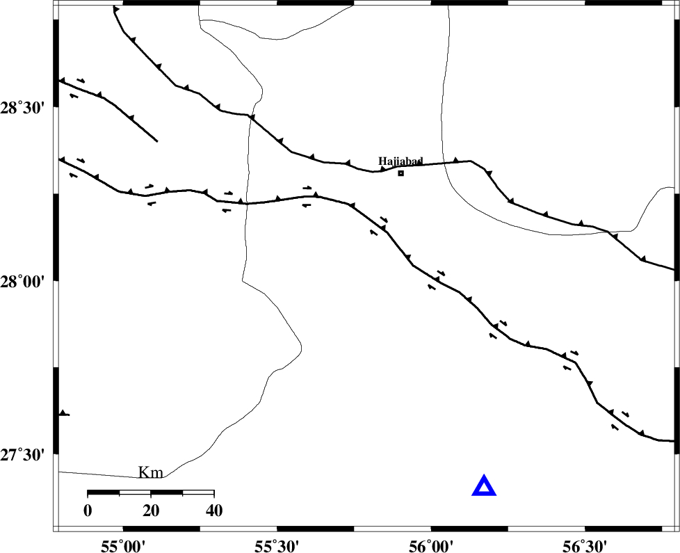
| Location | Lat:28.04 Lon: 55.79 |
| Region | 31 km South-West of Hajiabad, Hormozgan Province |
Nearest Cities |
|
| 32 km South West of Hajiabad, Hormozgan Province | |
| 41 km North East of Darz, Fars Province | |
| 44 km North West of Fareqan, Hormozgan Province | |
| 46 km North West of Fin, Hormozgan Province | |
| 62 km South East of Fadami, Fars Province | |
| Depth | 14 km |
| Agency | |
Faults within 150 km: |
|
| HZF2 (Length: 437 km) , Distance to epicenter: 13 km | |
| MAIN_ZAGROS_R_F (Length: 1106 km) , Distance to epicenter: 30 km | |
| HZF1 (Length: 102 km) , Distance to epicenter: 78 km | |
| Number of Phases | 4 |
| RMS | 0.2 |
| Number of Stations | 3 |
| Error in Latitude | >2.4 km |
| Error in Longitude | 6.4 km |
| Error in Depth | 9.7 km |
Download waveform in seisan format
to download seisan software Click here
to access information about IIEES stations Click here
Amplitude | ||||||||
| UID | Agency | Station | Component | Amplitude | Period | Arrival Time | Proccessing Time | Signal Clip |
| 39807 | IIEES | BNDS | N | 446 | 0.52 | 2007-10-13 00:19:52 | 2008-04-12 10:47:00 | n |
| 39808 | IIEES | KRBR | N | 72.2 | 0.44 | 2007-10-13 00:20:29 | 2008-04-12 10:47:00 | n |
| 39809 | IIEES | KRBR | E | 51.2 | 0.56 | 2007-10-13 00:20:33 | 2008-04-12 10:47:00 | n |
| 39810 | IIEES | GHIR | E | 23.2 | 0.45 | 2007-10-13 00:20:55 | 2008-04-12 10:47:00 | n |
Phase | ||||||||||||
| Agency | Station | Component | Phase Type | Phase Quality | First Motion | Observed Arrival Time | Time Residual | Loc. Flag | Input Weight | Distance | Azimuth | |
| IIEES | BNDS | Z | Pg | E | 2007-10-13 00:19:32 | -0.1 | y | 80.8 | 152 | |||
| IIEES | KRBR | Z | Pn | E | 2007-10-13 00:19:55 | 0.3 | y | 235 | 24 | |||
| IIEES | KRBR | N | Sg | E | 2007-10-13 00:20:24 | -0.1 | y | 235 | 24 | |||
| IIEES | GHIR | Z | Pn | E | 2007-10-13 00:20:00 | -0.1 | y | 276 | 276 | |||