
Magnitude |
:3.8 |
| Date & Time (UTC) | 2007-08-28 08:44:02.0 |
| Date & Time (Local) | 1386/6/6 12:14:02.0 |
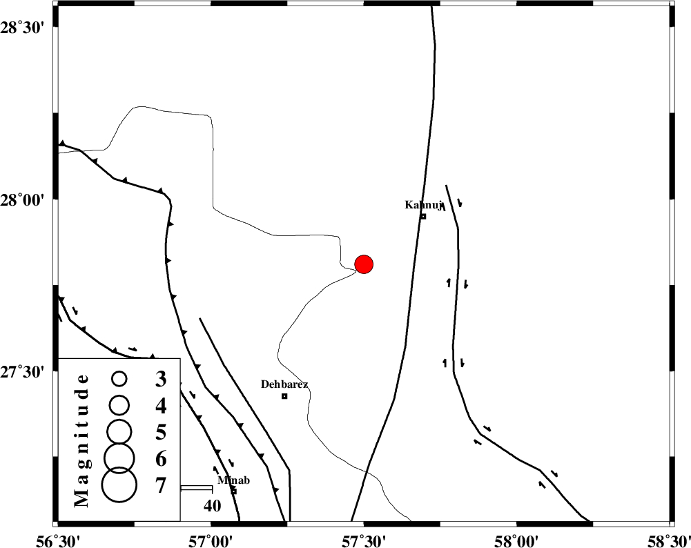
| Location | Lat:27.81 Lon: 57.5 |
| Region | 24 km South-West of Kahnuj, Kerman Province |
Nearest Cities |
|
| 22 km East of Fariab, Hormozgan Province | |
| 24 km North of Bejogan, Kerman Province | |
| 25 km South West of Kahnuj, Kerman Province | |
| 25 km North West of Bargah, Kerman Province | |
| 28 km North East of Ziaratali, Hormozgan Province | |
| Depth | 15 km |
| Agency | |
Faults within 150 km: |
|
| SABZEVARAN_F (Length: 190 km) , Distance to epicenter: 16 km | |
| JIROFT_F (Length: 144 km) , Distance to epicenter: 30 km | |
| ZENDAN_MINAB_F_Z1 (Length: 183 km) , Distance to epicenter: 56 km | |
| Number of Phases | 5 |
| RMS | 0.3 |
| Number of Stations | 5 |
| Error in Latitude | >9.4 km |
| Error in Longitude | 2.1 km |
| Error in Depth | 0 km |
Download waveform in seisan format
to download seisan software Click here
to access information about IIEES stations Click here
Amplitude | ||||||||
| UID | Agency | Station | Component | Amplitude | Period | Arrival Time | Proccessing Time | Signal Clip |
| 39564 | IIEES | ZHSF | N | 149.1 | 0.58 | 2007-08-28 08:45:58 | 2007-11-04 01:43:00 | n |
| 39565 | IIEES | GHIR | N | 134.5 | 0.53 | 2007-08-28 08:46:23 | 2007-11-04 01:43:00 | n |
| 39566 | IIEES | GHIR | E | 139.4 | 0.47 | 2007-08-28 08:46:29 | 2007-11-04 01:43:00 | n |
Phase | ||||||||||||
| Agency | Station | Component | Phase Type | Phase Quality | First Motion | Observed Arrival Time | Time Residual | Loc. Flag | Input Weight | Distance | Azimuth | |
| IIEES | ZHSF | Z | Pn | E | 2007-08-28 08:44:56 | 0 | y | 377 | 57 | |||
| IIEES | GHIR | Z | Pn | E | 2007-08-28 08:45:05 | 0 | y | 447 | 278 | |||
| IIEES | NASN | Z | Pn | E | 2007-08-28 08:45:38 | 0 | y | 714 | 322 | |||
| IIEES | DAMV | Z | Pn | E | 2007-08-28 08:46:15 | -0.5 | y | 1013 | 330 | |||
| IIEES | ASAO | Z | Pn | E | 2007-08-28 08:46:18 | 0.6 | y | 1032 | 318 | |||