
Magnitude |
:3.1 |
| Date & Time (UTC) | 2007-07-07 07:00:23.3 |
| Date & Time (Local) | 1386/4/16 10:30:23.3 |
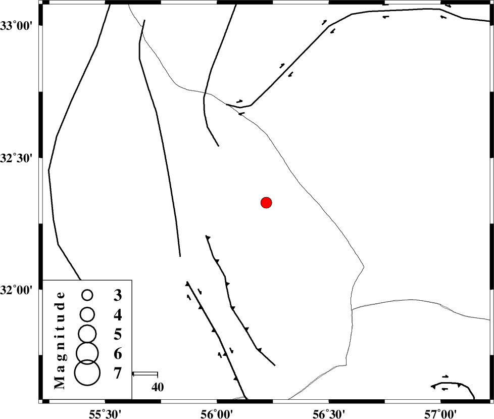
| Location | Lat:32.33 Lon: 56.22 |
| Region | 111 km North-East of Bafq, Yazd Province |
Nearest Cities |
|
| 54 km North East of Behabad, Yazd Province | |
| 68 km North East of Benestan, Yazd Province | |
| 74 km North of Asfih, Yazd Province | |
| 77 km North East of Kushk, Yazd Province | |
| 97 km North East of Basab, Yazd Province | |
| Depth | 14 km |
| Agency | |
Faults within 150 km: |
|
| JAFARABAD_F (Length: 60 km) , Distance to epicenter: 29 km | |
| NAINI_F (Length: 342 km) , Distance to epicenter: 31 km | |
| SARBALA_F (Length: 92 km) , Distance to epicenter: 39 km | |
| Number of Phases | 5 |
| RMS | 0.1 |
| Number of Stations | 4 |
| Error in Latitude | >4.7 km |
| Error in Longitude | 7.9 km |
| Error in Depth | 8.1 km |
Download waveform in seisan format
to download seisan software Click here
to access information about IIEES stations Click here
Amplitude | ||||||||
| UID | Agency | Station | Component | Amplitude | Period | Arrival Time | Proccessing Time | Signal Clip |
| 38972 | IIEES | KRBR | E | 214.1 | 0.61 | 2007-07-07 07:01:43 | 2007-11-04 01:43:00 | n |
| 38973 | IIEES | NASN | E | 40.8 | 0.45 | 2007-07-07 07:02:00 | 2007-11-04 01:43:00 | n |
| 38974 | IIEES | DAMV | E | 10.7 | 0.47 | 2007-07-07 07:03:15 | 2007-11-04 01:43:00 | n |
Phase | ||||||||||||
| Agency | Station | Component | Phase Type | Phase Quality | First Motion | Observed Arrival Time | Time Residual | Loc. Flag | Input Weight | Distance | Azimuth | |
| IIEES | KRBR | Z | Pn | E | 2007-07-07 07:01:04 | 0.1 | y | 265 | 169 | |||
| IIEES | KRBR | N | Sg | E | 2007-07-07 07:01:38 | 0 | y | 265 | 169 | |||
| IIEES | NASN | Z | Pn | E | 2007-07-07 07:01:11 | 0 | y | 324 | 280 | |||
| IIEES | DAMV | Z | Pn | E | 2007-07-07 07:01:37 | 0 | y | 537 | 314 | |||
| IIEES | CHTH | Z | Pn | E | 2007-07-07 07:01:47 | -0.1 | y | 615 | 312 | |||