
Magnitude |
:3.1 |
| Date & Time (UTC) | 2007-07-04 10:06:34.0 |
| Date & Time (Local) | 1386/4/13 13:36:34.0 |
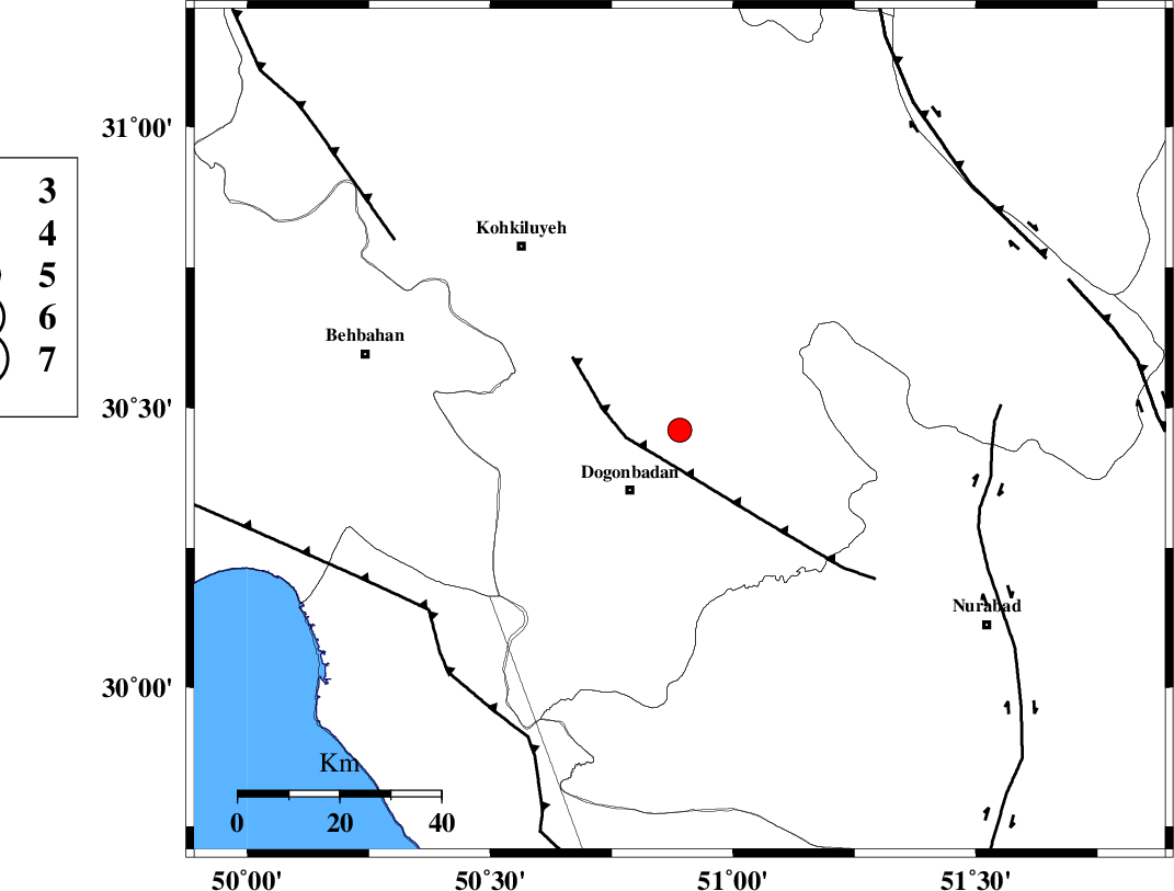
| Location | Lat:30.46 Lon: 50.89 |
| Region | 15 km North-East of Dogonbadan, Kohkiluieh va boyerahmad Province |
Nearest Cities |
|
| 15 km North West of Abdehgah, Kohkiluieh va boyerahmad Province | |
| 15 km North East of Dogonbadan, Kohkiluieh va boyerahmad Province | |
| 28 km North West of Basht, Kohkiluieh va boyerahmad Province | |
| 41 km North West of Kopon olia, Fars Province | |
| 47 km North West of Chehar taq, Fars Province | |
| Depth | 15 km |
| Agency | |
Faults within 150 km: |
|
| MISHAN_F (Length: 76 km) , Distance to epicenter: 7 km | |
| ZFF3 (Length: 125 km) , Distance to epicenter: 61 km | |
| RAG_E_SEFID_F (Length: 84 km) , Distance to epicenter: 61 km | |
| Number of Phases | 6 |
| RMS | 0.4 |
| Number of Stations | 6 |
| Error in Latitude | >5.9 km |
| Error in Longitude | 4.6 km |
| Error in Depth | 0 km |
Download waveform in seisan format
to download seisan software Click here
to access information about IIEES stations Click here
Amplitude | ||||||||
| UID | Agency | Station | Component | Amplitude | Period | Arrival Time | Proccessing Time | Signal Clip |
| 38872 | IIEES | GHIR | N | 59.4 | 0.58 | 2007-07-04 10:08:18 | 2007-11-04 01:43:00 | n |
| 38873 | IIEES | ASAO | N | 31 | 0.77 | 2007-07-04 10:08:55 | 2007-11-04 01:43:00 | n |
Phase | ||||||||||||
| Agency | Station | Component | Phase Type | Phase Quality | First Motion | Observed Arrival Time | Time Residual | Loc. Flag | Input Weight | Distance | Azimuth | |
| IIEES | SHGR | Z | Pn | E | 2007-07-04 10:07:15 | 0.3 | y | 270 | 313 | |||
| IIEES | GHIR | Z | Pn | E | 2007-07-04 10:07:20 | -0.1 | y | 315 | 139 | |||
| IIEES | NASN | Z | Pn | E | 2007-07-04 10:07:21 | 0.5 | y | 317 | 35 | |||
| IIEES | GHVR | Z | Pn | E | 2007-07-04 10:07:37 | 0.2 | y | 447 | 4 | |||
| IIEES | ASAO | Z | Pn | E | 2007-07-04 10:07:38 | -0.4 | y | 461 | 350 | |||
| IIEES | DAMV | Z | Pn | E | 2007-07-04 10:07:53 | -0.8 | y | 582 | 10 | |||