
Magnitude |
:3.6 |
| Date & Time (UTC) | 2007-06-27 00:08:50.3 |
| Date & Time (Local) | 1386/4/6 03:38:50.3 |
| Location | Lat:29.68 Lon: 51.52 |
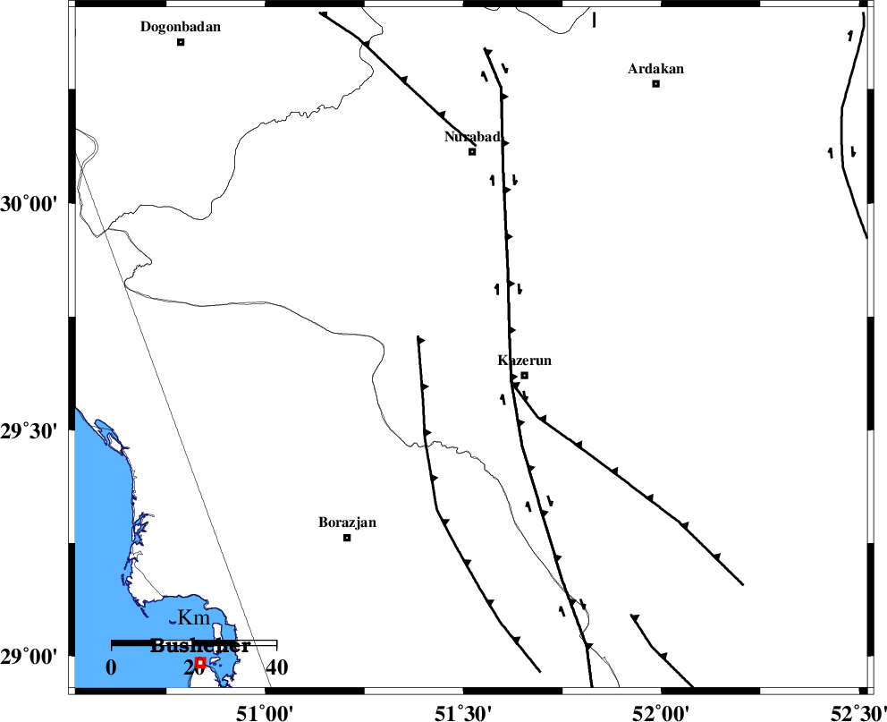
| Region | 14 km West of Kazerun, Fars Province |
Nearest Cities |
|
| 5 km North of Deris, Fars Province | |
| 7 km North of Kamaraj, Fars Province | |
| 15 km North West of Kazerun, Fars Province | |
| 17 km South West of Seyyed hasan, Fars Province | |
| 20 km North West of Mehranjan, Fars Province | |
| Depth | 14 km |
| Agency | |
Faults within 150 km: |
|
| KAZERUN_F (Length: 96 km) , Distance to epicenter: 3 km | |
| BORAZJAN_F (Length: 168 km) , Distance to epicenter: 31 km | |
| ZFF3 (Length: 125 km) , Distance to epicenter: 49 km | |
| Number of Phases | 5 |
| RMS | 0.1 |
| Number of Stations | 5 |
| Error in Latitude | >6.1 km |
| Error in Longitude | 4 km |
| Error in Depth | 11.9 km |
Download waveform in seisan format
to download seisan software Click here
to access information about IIEES stations Click here
Amplitude | ||||||||
| UID | Agency | Station | Component | Amplitude | Period | Arrival Time | Proccessing Time | Signal Clip |
| 38646 | IIEES | GHIR | E | 511.1 | 0.32 | 2007-06-27 00:09:57 | 2007-07-30 02:44:00 | n |
| 38647 | IIEES | GHIR | N | 572.9 | 0.44 | 2007-06-27 00:10:00 | 2007-07-30 02:44:00 | n |
| 38648 | IIEES | SHGR | N | 171.4 | 0.6 | 2007-06-27 00:10:48 | 2007-07-30 02:44:00 | n |
| 38649 | IIEES | KRBR | N | 55.4 | 0.36 | 2007-06-27 00:11:00 | 2007-07-30 02:44:00 | n |
| 38650 | IIEES | KRBR | E | 55 | 0.48 | 2007-06-27 00:11:07 | 2007-07-30 02:44:00 | n |
Phase | ||||||||||||
| Agency | Station | Component | Phase Type | Phase Quality | First Motion | Observed Arrival Time | Time Residual | Loc. Flag | Input Weight | Distance | Azimuth | |
| IIEES | GHIR | Z | Pg | E | 2007-06-27 00:09:24 | 0 | y | 210 | 137 | |||
| IIEES | NASN | Z | Pn | E | 2007-06-27 00:09:43 | -0.1 | y | 367 | 19 | |||
| IIEES | SHGR | Z | Pn | E | 2007-06-27 00:09:44 | 0 | y | 374 | 317 | |||
| IIEES | KRBR | Z | Pn | E | 2007-06-27 00:10:01 | 0.1 | y | 508 | 85 | |||
| IIEES | DAMV | Z | Pn | E | 2007-06-27 00:10:20 | 0.1 | y | 661 | 4 | |||